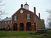
Clifton is an incorporated town located in southwestern Fairfax County, Virginia, United States, with a population of 243 at the time of the 2020 census.

The Battle of Blackburn's Ford took place on July 18, 1861, in the Confederate state of Virginia, as part of the Manassas campaign of the American Civil War. Union general Irvin McDowell's Army of Northeastern Virginia was marching south towards the Confederate capital of Richmond, and encountered the Confederate Army of the Potomac under the command of P. G. T. Beauregard. McDowell sent troops from Daniel Tyler's division to probe the Confederate defenses along Bull Run Creek to locate the Confederate left flank. At Blackburn's Ford, the Union troops attempted to cross but Confederate fire broke up the attack. The repulse at Blackburn's Ford led McDowell to seek to attack the Confederates at a different point along their line, leading to the First Battle of Bull Run three days later.

The First Battle of Rappahannock Station, as took place on August 23, 1862, at present-day Remington, Virginia, as part of the Northern Virginia Campaign of the American Civil War.

The Battle of Mine Run, also known as Payne's Farm, or New Hope Church, or the Mine Run campaign, was conducted in Orange County, Virginia, in the American Civil War.
NOVA Parks is an inter-jurisdictional organization that owns and operates more than 10,000 acres of woodlands, streams, parks, trails, nature reserves, countryside and historic sites in Northern Virginia in the United States. The Authority was organized in 1959. NOVA Parks presently operates 34 regional parks.

Bull Run is a 31.8-mile-long (51.2 km) tributary of the Occoquan River that originates from a spring in the Bull Run Mountains in Loudoun County, Virginia, and flows south to the Occoquan River. Bull Run serves as the boundary between Loudoun County and Prince William County, and between Fairfax County and Prince William County.

Colchester is a historic unincorporated community on the Occoquan River in Fairfax County, Virginia.

The 2nd Vermont Brigade was an infantry brigade in the Union Army of the Potomac during the American Civil War.
The 14th Vermont Infantry Regiment was a nine months' infantry regiment in the Union Army during the American Civil War. It served in the eastern theater, predominantly in the Defenses of Washington, from October 1862 to August 1863. It was a member of the 2nd Vermont Brigade.
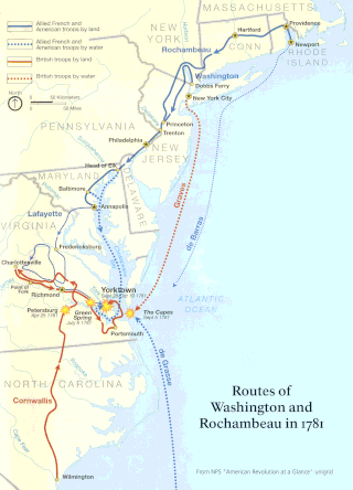
The Washington–Rochambeau Revolutionary Route is a 680-mile (1,090 km) series of roads used in 1781 by the Continental Army under the command of George Washington and the Expédition Particulière under the command of Jean-Baptiste de Rochambeau during their 14-week march from Newport, Rhode Island, to Yorktown, Virginia.

Fort Willard is a former Union Army installation now located in the Belle Haven area of Fairfax County in the U.S. state of Virginia. It is currently undergoing preservation treatment to protect its earthen walls and trenches.

State Route 612 in Fairfax and Prince William counties, Virginia, is a secondary state highway. The two counties are separated by water, so SR 612 contains a bridge that is one of only eight crossings between the counties. Because of this, SR 612 is heavily traveled during rush hour.
Bull Run Regional Park is a 1,568-acre (635 ha) multi-use facility located in Centreville, Virginia, owned and operated by the Northern Virginia Regional Park Authority.
Fort O'Rourke is a former Union Army installation now located in the Belle Haven area of Fairfax County in the U.S. state of Virginia. It was the southernmost fort built to defend Washington, D.C. in the American Civil War.

Upton's Hill, or Upton Hill, is a geographic eminence located in western Arlington County, Virginia. Its summit rises to 413 feet (126 m) above sea level and is located in Fairfax County just over the Arlington county boundary and just east of the driveway to Upton Hill Regional Park, near the batting cage.

The Occoquan River is a tributary of the Potomac River in Northern Virginia, where it serves as part of the boundary between Fairfax and Prince William counties. The river is a scenic area, and several local high schools and colleges use the river for the sport of rowing.

The Battle of Vienna, Virginia was a minor engagement between Union and Confederate forces on June 17, 1861, during the early days of the American Civil War.

Occoquan Regional Park is a regional park along a tributary of the Potomac River, located in Lorton in Fairfax County in Northern Virginia, USA.

The Battle of Fairfax Court House was fought during the Gettysburg Campaign of the American Civil War between two cavalry detachments from the Union Army of the Potomac, commanded by General Joseph Hooker, and the Confederate Army of Northern Virginia, commanded by General Robert E. Lee.
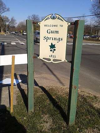
Gum Springs is a community in Fairfax County in Hybla Valley along Route 1. The African American community, the oldest in the county, was established in 1833 by West Ford, a freedman who had been manumitted by Hannah Bushrod Washington, in 1805. A historical marker was erected by the Virginia Department of Historic Resources in 1991.