
The Key Peninsula is a finger of land in Puget Sound, Washington, United States. It is approximately 16 miles (26 km) long and extends south from the Kitsap Peninsula. It is part of Pierce County, Washington. Some of its towns include: Wauna, Key Center, Vaughn, Home, Lakebay, and Longbranch. Its name is derived from the key-like shape of the peninsula.
Oakland Bay is a tidal estuarial body of water near the town of Shelton, Washington. It is connected to the larger Puget Sound via Hammersley Inlet. The community of Bay Shore, Washington was located on Oakland Bay. The major freshwater inlet is Goldsborough Creek, which runs through the town of Shelton.
Stretch Island is an island in Case Inlet in the southern part of Puget Sound in the U.S. state of Washington. It forms part of the unincorporated Mason County community of Allyn-Grapeview. The island has a land area of 1.2179 km² and a population of 119 persons as of the 2000 census. On the island's north side, it has buoys for overnight mooring, and Stretch Point State Park, a small state park only accessible by boat.

Pickering Passage is a strait, in the southern end of part of Puget Sound in the U.S. state of Washington. Entirely within Mason County, the Pickering Passage separates Hartstine Island from the mainland, and connects Totten Inlet with the north end of Case Inlet.
The Manette Peninsula is a headland that is part of the larger Kitsap Peninsula, located on the eastern flank of the Kitsap Peninsula, in western Washington (state), USA.

Hammersley Inlet, in southwestern Puget Sound in the U.S. state of Washington, is an arm of water leading to Shelton, Washington and Oakland Bay. Hammersley Inlet is also known as Big Skookum.
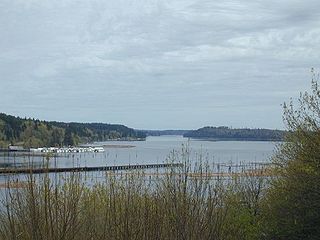
Case Inlet, in southern Puget Sound in the U.S. state of Washington, is an arm of water between Key Peninsula on the east and Hartstine Island on the west. Its northern end, called North Bay, reaches nearly to Hood Canal, creating the defining isthmus of Kitsap Peninsula. Case Inlet is the boundary between Pierce County and Mason County. The southern end of Case Inlet is connected to Nisqually Reach, part of the southern basin of Puget Sound. Herron Island lies in Case Inlet.

Vaughn is a census-designated place and unincorporated community in Pierce County, Washington, United States. Vaughn is located on Vaughn Bay in the northwestern Key Peninsula. Vaughn has a post office with ZIP code 98394.

Clara Brown was a sternwheel steamboat of the Puget Sound Mosquito Fleet which operated from the late 1880s to the early 1900s, and possibly as late as 1930.

Sentinel was a small wooden propeller-driven steamship of the Puget Sound Mosquito Fleet.

Messenger was a sternwheel steamboat of the Puget Sound Mosquito Fleet.
Audrey was a small steam vessel that operated on Puget Sound in the early part of the 1900s. The vessel was converted to a diesel tug and operated as such for many years on Puget Sound.

Burton was a steamboat built in 1905 in Tacoma, Washington and which was in service on Puget Sound until 1924.
Case Inlet steamboats served the small communities along the shore of Case Inlet in southern Puget Sound from the 1870s to 1924.
Bay Shore, Washington was a small community located on Oakland Bay in southern Puget Sound, not far away from the present city of Shelton, Washington.
Agate was a small community in the state of Washington, United States. It was located on southern Puget Sound on the north side of the entrance to Hammersley Inlet.
Oyster Bay is an inlet in southern Puget Sound which branches off from Totten Inlet. The bay spans Mason and Thurston counties, in the U.S. state of Washington. Kennedy Creek empties into the bay at the U.S. Highway 101 overpass.
Little Skookum Inlet is a branch of southern Puget Sound which extends westward from Totten Inlet. The community of Kamilche, Washington is on Little Skookum Inlet.
Arcadia, Washington is an unincorporated community in Mason County, Washington, which is located on southwest Puget Sound on a point of land which extends between Hammersley Inlet on the north and Totten Inlet on the south. It is situated between Olympia, Washington and Shelton, Washington.


