Related Research Articles

Hancock is a city in the Upper Peninsula of the U.S. state of Michigan. The population of Hancock was 4,501 at the 2020 census. The city is located within Houghton County, and is situated upon the Keweenaw Waterway, a channel of Lake Superior that cuts across the Keweenaw Peninsula. Hancock is located across the Keweenaw Waterway from the city of Houghton, and is connected to that city by the Portage Lake Lift Bridge. The city is located within Michigan's Copper Country region.

Keweenaw County is a county in the western Upper Peninsula of the U.S. state of Michigan. As of the 2020 census, the county's population was 2,046, making it Michigan's least populous county. It is also the state's largest county by total area, including the waters of Lake Superior, as well as the state's northernmost county. The county seat is Eagle River.

Calumet Township, officially the Charter Township of Calumet, is a charter township of Houghton County in the Upper Peninsula of the U.S. state of Michigan. The population was 6,263 at the 2020 census. Even with a decreasing population, the township remains the largest township by population in Houghton County.

Allouez Township is a civil township of Keweenaw County in the U.S. state of Michigan. The population was 1,428 at the 2020 census.

Eagle Harbor Township is a civil township of Keweenaw County in the U.S. state of Michigan. The population was 217 at the 2020 census. The township is located on the Keweenaw Peninsula and also includes the southwestern portion of Isle Royale National Park.
The Keweenaw Peninsula is a peninsula of the U.S. state of Michigan. Part of the greater landmass of the Upper Peninsula, the Keweenaw Peninsula projects about 65 miles (105 km) northeasterly into Lake Superior, forming Keweenaw Bay. The peninsula is part of Michigan's Copper Country region, as the region was home to the first major copper mining boom in the United States. Copper mining was active in this region from the 1840s to the 1960s.
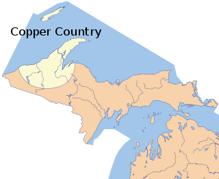
The Copper Country is an area in the Upper Peninsula of Michigan in the United States, including Keweenaw County, Michigan, Houghton, Baraga and Ontonagon counties as well as part of Marquette County. The area is so named as copper mining was prevalent there from 1845 until the late 1960s, with one mine continuing through 1995. In its heyday in the latter half of the 19th century and the early 20th century, the area was the world's greatest producer of copper.

The Keweenaw Waterway is a partly natural, partly artificial waterway which cuts across the Keweenaw Peninsula of Michigan; it separates Copper Island from the mainland. Parts of the waterway are variously known as the Keweenaw Waterway, Portage Canal, Portage Lake Canal, Portage River, Lily Pond, Torch Lake, and Portage Lake. The waterway connects to Lake Superior at its north and south entries, with sections known as Portage Lake and Torch Lake in between. The primary tributary to Portage Lake is the Sturgeon River.

The Quincy Mine is an extensive set of copper mines located near Hancock, Michigan. The mine was owned by the Quincy Mining Company and operated between 1846 and 1945, although some activities continued through the 1970s. The Quincy Mine was known as "Old Reliable," as the Quincy Mine Company paid a dividend to investors every year from 1868 through 1920. The Quincy Mining Company Historic District is a United States National Historic Landmark District; other Quincy Mine properties nearby, including the Quincy Mining Company Stamp Mills, the Quincy Dredge Number Two, and the Quincy Smelter are also historically significant.

In Michigan, copper mining became an important industry in the 19th and early 20th centuries. Its rise marked the start of copper mining as a major industry in the United States.

The Cliff mine was the first successful copper mine in the Copper Country of the state of Michigan in the United States. The mine is at the now-abandoned town of Clifton in Keweenaw County. Mining began in 1845, and the Cliff was the most productive copper mine in the United States from 1845 through 1854. Large-scale mining stopped in 1878.

The Calumet Historic District is a National Historic Landmark District that encompasses most of the village of Calumet, Michigan. The district was designated in 1989 for the community's importance in the history of the region's copper mining industry.

The Calumet and Hecla Industrial District is a historic district located in Calumet, Michigan and roughly bounded by Hecla & Torch Lake Railroad tracks, Calumet Avenue, Mine and Depot Streets. The district contains structures associated with the copper mines worked by the Calumet and Hecla Mining Company, located along a line above the copper lode, where railroad tracks connected separate mine heads. The Historic District is completely contained in the Calumet Historic District and the Keweenaw National Historical Park. It was designated a Michigan State Historic Site in 1973 and was listed on the National Register of Historic Places in 1974.

The Smith–Dengler House is a private home located at 58555 US 41 in Wolverine, Calumet Charter Township, Michigan, United States. It was listed on the National Register of Historic Places in 2008.

The Quincy Mining Company Stamp Mills Historic District is a historic stamp mill located on M-26 near Torch Lake, just east of Mason in Osceola Township. It was listed on the National Register of Historic Places in 2007.

The Quincy Smelter, also known as the Quincy Smelting Works, is a former copper smelter located on the north side of the Keweenaw Waterway in Ripley, Michigan. It is a contributing property of the Quincy Mining Company Historic District, a National Historic Landmark District. The smelter was built in 1898 by the Quincy Mining Company, operating from 1898 to 1931 and again from 1948 to 1971. The smelter was part of a Superfund site from 1986 to 2013.
The Michigan Smelter was a copper smelter located at Cole's Creek on the Keweenaw Waterway north-west of Houghton, Michigan near the old Atlantic mill. The smelter was created in 1903-4 as a joint effort between the Copper Range Company and Stanton group of mines. An Atlantic dam on the site was reused by the smelter as a water source. In 1905, the smelter broke a world record by casting 292,000 pounds of fine copper in seven hours with a single furnace and only ten men. The smelter operated through World War II and stopped all operations in 1948.
The Atlantic Mill was located on the east side of Redridge, Michigan near the Redridge Steel Dam. It was constructed in 1892 and closed in 1912. It was connected to the Atlantic mine via a 9 mile long Atlantic and Lake Superior Railroard. The previous path of the railroad is now a scenic tree-covered road. It is thought that currents have moved the stamp sand produced by this mill to the current site of the North Canal Township Park.
The Victoria Mine is the name given to a series of copper mines located in Rockland Township, Ontonagon County, in Michigan's Copper Country. It was near this location that a large piece of float copper, known as the Ontonagon Boulder, was found. The mine operated off and on from 1849 until its final closure in 1921. Most of the metal found there was low grade native copper from the Forest Lode. Quartz, epidote, calcite, prehnite, and pumpellyite are also found in the rock.
The Mohawk Mining Company was a major copper mining company, based in the Keweenaw Peninsula of Michigan, that was established in November 1898 and lasted until 1932. The company, between 1906 and 1932, paid out more than $15 million in shareholder dividends. The Mine is best known for the large amounts of mohawkite that were found on the property. The Mohawk mine operated until 1932; in 1934 it was purchased by the Copper Range Company.
References
- ↑ Wolverine Copper Mining Company (1892). Report. C.H. Clayton & Co. pp. 5–6.
- ↑ Molloy, Lawrence J. (2008). A Guide to Michigan's Historic Keweenaw Copper District: Photographs, Maps, and Tours of the Keweenaw, Past and Present. Hubbell, Michigan: Great Lakes GeoScience. pp. 62, 65. ISBN 978-0-979-1772-1-7.
- ↑ Wolverine Copper Mining Company (1892). Report. C.H. Clayton & Co. pp. 5, 14, 17.
- ↑ "Wolverine Mine" (PDF). Wausau Prospectors. 5 (9): 7. June 2012.