Wood Mill, Woodley

Last updated
Wood Mill
Wood Mill, Woodley, just prior to demolition (1963).jpg
Wood Mill, Woodley (1963)
Greater Manchester UK location map 2.svg
Red pog.svg
Location within Greater Manchester
Location Woodley, Greater Manchester
Coordinates 53°25′57″N2°06′07″W / 53.4325°N 2.1020°W / 53.4325; -2.1020 Coordinates: 53°25′57″N2°06′07″W / 53.4325°N 2.1020°W / 53.4325; -2.1020
Construction
Demolished1964

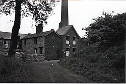
Wood Mill was a mill located by the River Tame in Stockport, Cheshire. Originally built in the early to mid 19th century and used as a bone mill. After 1848 the building was converted to a woollen mill and was rebuilt in 1864. In the 1930s, the building was used for colour and chemical manufacturing and demolished in 1964. The remains of the building are located on the bend of Lambeth Grove, Woodley between Wellington Works (occupied by Morrells Woodfinishes) and Riverside Kennels.

Contents

History

In 1841, Wood Mill was owned by William Vaudrey and used as a bone mill, the final product of which was used to fertalise local land. Originally the mill was water powered using a fast flowing stream, running from Werneth Low, that ran alongside the building. There was also a water reservoir (mill dam) situated south of the building to increase the head of water available for the water wheel.

In 1864, John Lees Buckley acquired Wood Mill. It was at this time that Wood Mill was rebuilt to allow for fur blowing, carding and wool washing for the hatting industry. It was also around this time that the Buckley family rebuilt other mills in the area. Bottom Mill (then renamed Botany Mill, later changed to Wellington Works) in 1864, Top Mill in 1872 (extended in 1877) and Middle Mill in 1883 (later renamed Thorn Works). It is also known that the Buckley family ween keen Methodists, and in 1868 they built Woodley Methodist Church (rebuilt 1998).

Wood Mill being demolished in 1964 after the collapse of Ashbrooks (1932) Ltd. Wood Mill, Woodley being demolished for redevelopment (1964).jpg
Wood Mill being demolished in 1964 after the collapse of Ashbrooks (1932) Ltd.

In the 1930s Wood Mill was occupied by Ashbrooks (1932) Limited (directors: Frederick Fletcher & Gertrude Fletcher), manufactures of fine art colours, pigments and chemicals. It was during this period that the larger chimney was built for the use of a boiler. This company used the building until its subsequent demise in early 1964. It was later in this year that the building was demolished, however it wasn't until a number of years later when the chimney was taken down.

Modern day

Currently, the site of Wood Mill is heavily overgrown with trees. However two stone walls survive, at around 3 metres in height. Alongside this is the remains of a concrete wall, built around 1950 and used to filter out chemicals and colours that would otherwise flow into the River Tame. Further up the stream is red brick wall with irrigation pipes inside. There is also a concrete floor/foundation running between the end of the stone wall and the start of the red brick wall. The water reservoir (mill dam) has since been drained, however there are still stone walls that were used to hold the water.

The stream at the site of Wood Mill, 2009, with stone wall on left. Stream along Wood Mill - 2009.jpg
The stream at the site of Wood Mill, 2009, with stone wall on left.

The stream

The stream running alongside Wood Mill can be mapped to a source from Werneth Low. After flowing under The Peak Forest Canal at Woodley Wharf, the water flows through an area that was once a Mill Dam for Top Mill. From here it goes through a culvert under Mill Pool Close into an area that was once the Mill Dam for Middle Mill (now known as Thorn Works). It is from here that it flows under the road once again, past Botany Mill (now Wellington Works) through a number of culverts until it surfaces alongside the site of Wood Mill, under the road and into the River Tame.

See also

Related Research Articles

Disley Human settlement in England

Disley is a village and civil parish in Cheshire, England, on the edge of the Peak District in the Goyt valley south of Stockport, close to the county boundary with Derbyshire at New Mills. The population at the 2011 Census was 4,294. To the north, the River Goyt and the Peak Forest Canal, which opened in 1800, pass along the edge of the village. Today it is a dormitory village retaining a semi-rural character.

Stockport Human settlement in England

Stockport is a large town in Greater Manchester, England, 7 miles (11 km) south-east of Manchester city centre, where the River Goyt and Tame merge to create the River Mersey. It is the largest town in the metropolitan borough of the same name.

River Tame, Greater Manchester River in Greater Manchester, England

The River Tame flows through Greater Manchester, England. It rises on Denshaw Moor and flows to Stockport where it joins the River Goyt to form the River Mersey.

Reddish Human settlement in England

Reddish is an suburb in the Metropolitan Borough of Stockport, Greater Manchester, England, 2 miles (3.2 km) north of Stockport and 4.6 miles (7.4 km) south-east of Manchester. At the 2011 Census, the population was 28,052. Historically part of Lancashire, Reddish grew rapidly in the Industrial Revolution and still retains landmarks from that period, such as Houldsworth Mill, a former textile mill.

Hyde, Greater Manchester Town in Tameside, Greater Manchester, England

Hyde is a town in Tameside, Greater Manchester, England, which had a population of 34,003 in 2011.

Flowery Field Human settlement in England

Flowery Field is an area of Hyde, Greater Manchester, England.

Cheshire Lines Committee Railway in England: active from 1863 to 1947

The Cheshire Lines Committee (CLC) was formed in the 1860s and became the second-largest joint railway in Great Britain. The committee, which was often styled the Cheshire Lines Railway, operated 143 miles (230 km) of track in the then counties of Lancashire and Cheshire. The railway did not get grouped into one of the Big Four during the implementation of the 1923 grouping, surviving independently with its own management until the railways were nationalised at the beginning of 1948. The railway served Liverpool, Manchester, Stockport, Warrington, Widnes, Northwich, Winsford, Knutsford, Chester and Southport with connections to many other railways.

Woodley, Greater Manchester Human settlement in England

Woodley is a suburb in the Metropolitan Borough of Stockport, Greater Manchester, England, on the east side of the Peak Forest Canal, next to Bredbury and Romiley and the boundary with Gee Cross, Tameside.

Romiley Human settlement in England

Romiley is a village in the Metropolitan Borough of Stockport, Greater Manchester, England. Historically part of Cheshire, it borders Marple, Bredbury and Woodley. At the 2011 census, the Romiley ward, which includes Compstall, Bredbury Green and a large part of Bredbury, had a population of 14,139.

Bredbury Town, Greater Manchester

Bredbury is a town in the Metropolitan Borough of Stockport, Greater Manchester, England, 7.9 miles (12.7 km) south-east of Manchester, 1.8 miles (2.9 km) east of Stockport and 3.2 miles (5.1 km) south-west of Hyde. At the 2011 census, it had a population of 16,721.

Reddish Vale

Reddish Vale is in the Tame Valley close to Reddish, Greater Manchester, England. The centre of the vale is around the bottom of Reddish Vale Road. Reddish Vale Country Park is a country park managed by Stockport Metropolitan Borough Council. It covers 161 hectares in all and comprises some of the traditional Reddish Vale area, Reddish Vale Farm and the grazing land and Woodhall Fields, about half a mile to the south. Part of it is a designated local nature reserve.

Blackburn Brook Stream in Sheffield, South Yorkshire, England

The Blackburn Brook is a stream in Sheffield, South Yorkshire, England which flows through the Blackburn Valley along the M1 and Ecclesfield Road and joins the River Don near the Meadowhall shopping centre. Downstream from the A61 road at Chapeltown the Blackburn Brook is defined as a main river by the Environment Agency, which requires new building development to be at least 26 feet (8 m) from the bank side as a flood defence measure and to allow access to the watercourse for maintenance.

Hat Works Museum and former cotton mill Greater Manchester, England

The Hat Works is a museum in Stockport, Greater Manchester, England, which opened in 2000. Before that, smaller displays of hatting equipment were exhibited in Stockport Museum and in the former Battersby hat factory.

There is evidence of activity around Reddish – a settlement in Greater Manchester, England – before the Norman conquest in the presence of Nico Ditch and some Saxon coins. The recorded history of Reddish begins at the turn of the 13th century when it was documented as "Redich". Reddish remained a predominantly rural settlement throughout the medieval period, but expanded to become a mixed industrial and residential area during the 19th century. It developed rapidly during the Industrial Revolution, and still retains landmarks from that period, such as Houldsworth Mill.

Piethorne Brook Stream in Greater Manchester, England

Piethorne Brook is a watercourse in Greater Manchester. It is a tributary of the River Beal.

Stockport Portwood railway station

Stockport Portwood railway station was a railway station in Stockport, England on the Stockport and Woodley Junction Railway

Heywood Branch Canal

The Heywood Branch Canal was a branch of the Rochdale Canal from Castleton which led to Heywood. It opened in 1834 and carried traffic until 1937. It was abandoned in 1952, along with most of the Rochdale Canal, and although the Rochdale Canal has been reopened, the junction lies under the embankments of the M62 motorway.

River Hipper

The River Hipper is a tributary of the River Rother in Derbyshire, England. Its source is a large expanse of wetlands, fed by the surrounding moors between Chatsworth and Chesterfield, known as the Hipper Sick on Beeley Moor, which is part of the Chatsworth Estate. It then passes through Holymoorside and down into Chesterfield, just south of the town centre, before flowing into the River Rother. In July 2007, parts of Chesterfield flooded when the River Hipper burst its banks during a substantial storm that caused extensive flooding in North Derbyshire and South Yorkshire.

River Drone

The River Drone is a river which flows south from its source on the Sheffield, South Yorkshire border. It flows through Dronfield, Unstone and Unstone Green in Derbyshire before merging at Sheepbridge to the north of Chesterfield with the Barlow Brook. Below the junction, it is often referred to as the River Whitting. It then flows south east till it merges with the River Rother at Brimington Road North (B6050) at Chesterfield. It is one of the three main tributaries of the Rother.

Eller Beck River in North Yorkshire, England

The Eller Beck is a small river in North Yorkshire, England, that flows through the town of Skipton and is a tributary of the River Aire. Its channel was heavily modified to supply water to mills in the 18th and 19th centuries, and although all the mills have closed, the water now supplies power to the National Grid, generated by a turbine at High Corn Mill. The beck flows through several underground culverts in Skipton that contribute to the flood risk. To alleviate flooding in Skipton town centre, a scheme involving two flood water storage reservoirs has been designed, but the start of the work to implement it was delayed in October 2014 by a shortfall in funding.

References

Books

Internet

Maps

Miscellaneous