
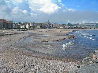
Stonehaven is a town in Scotland. It lies on Scotland's northeast coast and had a population of 11,602 at the 2011 Census. After the demise of the town of Kincardine, which was gradually abandoned after the destruction of its royal castle in the Wars of Independence, the Scottish Parliament made Stonehaven the successor county town of Kincardineshire. It is currently administered as part of the unitary authority of Aberdeenshire. Stonehaven had grown around an Iron Age fishing village, now the "Auld Toon", and expanded inland from the seaside. As late as the 16th century, old maps indicate the town was called Stonehyve,Stonehive, Timothy Pont also adding the alternative Duniness. It is known informally to locals as Stoney.

Kincardineshire, also known as the Mearns, is a historic county, registration county and lieutenancy area on the coast of northeast Scotland. It is bounded by Aberdeenshire on the north and west, and by Angus on the south.

Inverbervie is a small town on the north-east coast of Scotland, south of Stonehaven. Historically in Kincardineshire, it is today is administered as part of the Aberdeenshire council area.

Findon or Finnan is a fishing village eight miles south of Aberdeen, famous for originating the smoked haddock known as Finnan haddie. The Findon moor has a number of paths through it, many of which run along the cliffs. Deer can often be seen there. Nearby features include the Portlethen Moss Nature Reserve.

Johnshaven is a coastal village along the North Sea located in Aberdeenshire, Scotland. About 2 miles (3 km) southwest of Johnshaven lies Milton Ness, which includes a red sandstone cliff landform.
Newtonhill is a commuter town in Kincardineshire, Scotland. It is popular due to its location, just six miles south of Aberdeen with easy reach of Stonehaven and with views over the North Sea.
Kincardine Community Hospital is a small hospital at Kirkton Road, Stonehaven, Aberdeenshire, Scotland. It is managed by NHS Grampian.
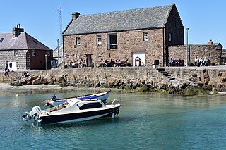
The Stonehaven Tolbooth is a late 16th-century stone building originally used as a courthouse and a prison in the town of Stonehaven, Aberdeenshire, Scotland. Constructed of local Old Red Sandstone, the prison probably attained its greatest note, when three local Episcopalian clergymen were imprisoned for holding services for more than nine people. Lying midway along the old north quay of the Stonehaven Harbour, the present day Tolbooth serves as a history museum with a restaurant on the floor above the ground floor. It is a category A listed building.
Tewel is a hamlet located approximately two miles west of Stonehaven, Kincardineshire on the Auchenblae Road in Northeast Scotland.
Carron Water is a river in Kincardineshire, Scotland.

The Bridge of Dee or Brig o Dee is a road bridge over the River Dee in Aberdeen, Scotland. The term is also used for the surrounding area of the city. Dating from 1527, the bridge crosses at what was once the City of Aberdeen's southern boundary. This was the site of a battle in 1639 between the Royalists under Viscount Aboyne and the Covenanters who were led by the Marquess of Montrose and Earl Marischal. This was the only substantial action of the First Bishops' War, and it took place after the peace treaty had already been signed.

Muchalls is a small coastal ex-fishing village in Kincardineshire, Scotland, south of Newtonhill and north of Stonehaven. Muchalls is situated slightly north of a smaller hamlet known as the Bridge of Muchalls. At the western edge of Muchalls is the historic Saint Ternan's Church. The rugged North Sea coastline near Muchalls features numerous cliffs, sea stacks and headlands, not infrequently in haar. The Grim Brigs headland is situated at Muchalls southern edge and Doonie Point headland is approximately 1.5 kilometres south.

Elsick House is a historic house in Kincardineshire, North-East Scotland. It is situated in an agricultural area about two miles from the North Sea near the town of Newtonhill; the Elsick Estate is situated within the watershed of the Burn of Elsick, a stream that traverses the estate. The house is located on the Elsick Estate, and is the present family seat of the Duke of Fife.
Auchenblae is a village in the Kincardine and Mearns area of Aberdeenshire, formerly in Kincardineshire, Scotland. The village was known for its weavers, a whisky distillery and the annual Paldie's Fair horse market.

Cowie is an historic fishing village in Kincardineshire, Scotland. This village has existed since the Middle Ages, but in current times it is effectively subsumed into the town of Stonehaven. It had an estimated population of 2,720 in 2020.

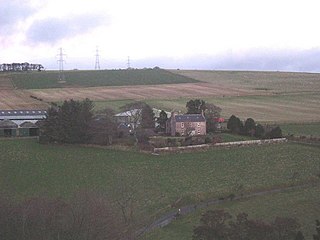
Rickarton House is a 19th-century country house in Kincardineshire, Scotland. It lies approximately three-and-a-half miles northwest of Stonehaven in the former county of Kincardineshire. The house is situated on the north banks of the Cowie Water slightly upstream of the confluence with Cowton Burn. Rickarton is a category B listed building. Rickarton House was constructed in the first decade of the 19th century for William Rickart Hepburn. He commissioned the City Architect of Aberdeen, John Smith, to undertake the work.
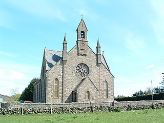
Cookney Parish Church, now business premises within a converted listed building, was a Christian place of worship in the village of Cookney, Aberdeenshire, Scotland.

Auld Bourtreebush is a large Neolithic stone circle near Portlethen in Aberdeenshire, Scotland. It is also known as Old Bourtree Bush or Old Bourtreebush. This megalithic construction is situated near the Aquhorthies recumbent stone circle and the Causey Mounth, an ancient trackway which connects the Scottish Lowlands to the highlands. It is a scheduled monument.

Laurencekirk railway station is a railway station serving the communities of Laurencekirk and The Mearns in Aberdeenshire, Scotland. The station was reopened on 18 May 2009 at a cost of £3 million.
Kincardine was a burgh in Scotland, near the present-day village of Fettercairn. It served as the first county town of Kincardineshire.


