Related Research Articles

The Royal Borough of Greenwich is a London borough in southeast Greater London, England. The London Borough of Greenwich was formed in 1965 by the London Government Act 1963. The new borough covered the former area of the Metropolitan Borough of Greenwich and part of the Metropolitan Borough of Woolwich to the east. The local council is Greenwich London Borough Council which meets in Woolwich Town Hall. The council's offices are also based in Woolwich, the main urban centre in the borough.
Westcombe Park is a largely residential area in Blackheath in the Royal Borough of Greenwich, South East London, England. It is bounded by the main London-Dartford railway line to the north, the Blackwall Tunnel southern approach to the east, the Blackheath common to the south and a road, Vanbrugh Hill, to the west.

The Metropolitan Borough of Woolwich was a metropolitan borough in the County of London from 1900 to 1965. It was formed from the civil parishes of Eltham, Plumstead and Woolwich. Its former area is now part of the Royal Borough of Greenwich and the London Borough of Newham.

Shooter's Hill is a district in South East London within the Royal Borough of Greenwich. It borders the London Borough of Bexley. It lies north of Eltham and south of Woolwich. With a height of 132 metres (433 ft), it is the highest point in the Borough of Greenwich and one of the highest points in Greater London. Shooter's Hill also gives its name to the A road which passes through east to west and is part of the A207 road, the A2 road, and also Watling Street.

Oxleas Wood is one of the few remaining areas of ancient deciduous forest in Eltham in the Royal Borough of Greenwich, in southeast London. Some parts date back over 8,000 years to the end of the last ice age, the Younger Dryas. It is part of a larger continuous area of woodland and parkland on the south side of Shooter's Hill: other parts are Jack Wood, Castle Wood, Oxleas Meadows, Falconwood Field, Eltham Common and Eltham Park North. Eltham Park North includes the ancient Shepherdleas Wood.

Coombe is a place in the London Borough of Croydon, situated south-east of central Croydon, between Addiscombe, Selsdon and Upper Shirley. Formerly a hamlet, since the growth of suburban development the area has become swallowed into the London conurbation and often does not appear on modern map.
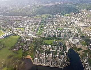
Abbey Wood is an area in southeast London, England, straddling the border between the Royal Borough of Greenwich and the London Borough of Bexley. It is located 10.6 miles (17 km) east of Charing Cross. According to the 2021 census, Abbey Wood has a population of 17,700.
College Farm is the only farm site in Finchley, in the London Borough of Barnet. It currently trades as an equestrian and pet store. It is located in Regents Park Road, close to Henlys Corner on the North Circular Road. It has two residential roads running alongside it; Allandale Avenue and Fitzalan Road.
The London Borough of Bexley owns and maintains over 100 parks and open spaces within its boundaries, with a total of 638 hectares. They include small gardens, river and woodland areas, and large parks with many sporting and other facilities.

The Portman Estate, covering 110 acres of Marylebone in London’s West End, was founded in 1532 when the land was first leased to Sir William Portman.
Hadlow College is a further and higher education college in Hadlow, Kent, England, with a satellite site in Greenwich. The curriculum primarily covers land-based subjects including Agriculture, Horticulture, Conservation and Wildlife Management, Animal Management, Fisheries Management, Equine Studies and Floristry. Additionally, intermediate and advanced apprenticeships are offered in Golf Greenkeeping, Sports Turf, Agriculture, Horticulture and Land-based Engineering.

The A209 road is a 2-mile (3.2 km) route in southeast London, England. It connects Plumstead in the north with Welling in the south, passing through East Wickham. It is known as Wickham Lane at the northern end in the Royal Borough of Greenwich and Upper Wickham Lane at the southern end in the London Borough of Bexley. The entire route is served by the London Buses route 96.

The Ridgeway is a 3.5-mile (5.6 km) "cycling permitted pedestrian priority" footpath owned by Thames Water in southeast London. It runs between Plumstead and Crossness on an embankment that covers the Joseph Bazalgette Southern Outfall Sewer.

Bostall Heath and Woods is an area of 159.1 hectares of woodland with areas of heathland located in the Royal Borough of Greenwich ward of Abbey Wood, west of Lesnes Abbey Woods in southeast London. The area to the south of the A206 is Bostall Woods; to the north is Bostall Heath.

Maryon Wilson Park is a public park in Charlton, in the Royal Borough of Greenwich in south east London. It is bounded on its northwest side by Thorntree Road; its southern-most, and highest, point is a gateway on to Charlton Park Road.

Eltham Common is a park and area of common land in the Royal Borough of Greenwich in south-east London. Forming an approximate triangle between Well Hall Road and Shooter's Hill, it is part of a larger continuous area of woodland and parkland on the south side of Shooter's Hill: other parts are Jack Wood, Castle Wood, Oxleas Meadows, Falconwood Field, Oxleas Wood and Eltham Park North.

Shrewsbury Park is a public park situated on Shooter's Hill, south of Woolwich, in the Royal Borough of Greenwich in south east London.
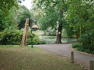
The Tarn is a 9 acres (3.6 ha) site on Court Road between Mottingham and Eltham, in the Royal Borough of Greenwich, southeast London, United Kingdom, consisting of a public garden, a bird sanctuary nature reserve and a lake amongst woodland. The woodland and lake, which was historically known as Starbuck's Pond, were previously the southern part of the Great Park, one of three parks belonging to the estate of Eltham Palace and used as a royal deer hunting park for several centuries up until the English Civil War. As a garden The Tarn opened in 1935, after the Metropolitan Borough of Woolwich acquired the site from the adjacent Royal Blackheath Golf Course. The Tarn remains largely unchanged since the 1930s and contains several shelters, benches, a public toilets building and a circular path which crosses a wooden footbridge spanning the lake. There is also an 18th-century ice house in the garden, which is a listed structure.

Horn Park is a 16 acres (6.5 ha) public park within Horn Park in the Eltham area of the Royal Borough of Greenwich, southeast London, United Kingdom. It has a mixture of grassland and woodland, children's playground, football pitch, outdoor gym and the first skate park in the Royal Borough of Greenwich. Historically Horn Park was one of three deer hunting parks belonging to Eltham Palace, over the centuries it was also used as grazing farmland and a fruit orchard. The park today is some of the last remaining open space of the original park, a public park next to the Horn Park housing estate which was completed just after the Second World War.

The Wogebourne is an 8 km (5.0 mi) tributary of the River Thames in the southeast London boroughs of Greenwich and Bexley, that flows generally in a northeasterly direction, from its source in Oxleas Wood in Shooter's Hill, to Thamesmead where it joins the Thames. The Wogebourne has appeared in records since at least the fourteenth century, and has been known by other names including Woghbourne, Plumstead River, and Wickham Valley Watercourse. The upper reaches of the watercourse in Shooter's Hill, Falconwood, Welling, and East Wickham are above ground through woodland, farmland and fields, where several smaller tributaries join; whereas the lower reaches in Plumstead, Abbey Wood, and Thamesmead are mostly underground within culverts. The final part of the river in Thamesmead was previously marshland which was drained in the nineteenth and twentieth centuries, where the Wogebourne now completes its course through a man-made lake called Southmere and a purpose-built channel named Crossway Canal which empties into the Thames at Crossness.
References
- 1 2 "History". Woodlands Farm Trust. Retrieved 14 April 2024.
- ↑ "Every prisoner of war camp in the UK mapped and listed". Guardian. 8 November 2010. Retrieved 14 April 2024.
- ↑ Stewart, John (May 2005). "A Road Can be Stopped!" (PDF). Road Block. Archived from the original (PDF) on 16 February 2008. Retrieved 14 May 2007.
- ↑ "Royal Borough of Greenwich Equestrian Skills". Hadlow College. Retrieved 14 April 2024.
- ↑ Norden, Robert (30 January 2000). "Thomas Is the Horse for an Accountants' Course". The Independent. Archived from the original on 5 November 2013. Retrieved 21 October 2013– via HighBeam Research.
- ↑ "The Woodlands Farm Trust". Social Farms & Gardens. Retrieved 14 April 2024.