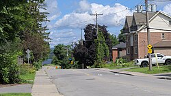
Westboro is an area in the west end of Ottawa, Ontario, Canada. Located along the Ottawa River, Island Park Drive defines Westboro's eastern border, while the Ottawa River defines its northern border. Under this definition, the population of the area is 22,725.

Ottawa West—Nepean is a federal electoral district in Ontario, Canada, that has been represented in the House of Commons of Canada since 1997.

Barrhaven is a suburb of Ottawa, Ontario, Canada. It is located about 17 km (11 mi) southwest of the city's downtown core. Prior to amalgamation with Ottawa in 2001, Barrhaven was part of the City of Nepean. Its population as of the Canada 2021 Census was 103,234.

Dominion is a station on the transitway in Ottawa, Ontario. It is located north of the western edge of Westboro village, where the below-grade transitway segment joins the Kichi Zībī Mīkan. The station is named after nearby Dominion Avenue.
Whitehaven is a neighbourhood located in Bay Ward in the west end of Ottawa, Ontario, Canada, about 10 kilometres west of downtown. It is bounded by Carling Avenue to the north, Woodroffe Avenue to the east, the OC Transpo Transitway to the west and Highway 417 to the south. As of 2021, the population of the neighbourhood is 2323.

Ottawa Centre is an urban provincial electoral district in Ontario, Canada that has been represented in the Legislative Assembly of Ontario since 1968. While the riding's boundaries have changed over the years to account for population changes, the riding has always comprised the central areas of Ottawa, the nation's capital.

Carlingwood is a neighbourhood in Bay Ward in the west end of Ottawa, Ontario, Canada. The neighbourhood is roughly bounded on the north by Richmond Road, on the east by Sherbourne Road, on the south by Carling Avenue and on the west by Woodroffe Avenue. This area corresponds to census tract 5050032.01, which had a population of 3,558 according to the Canada 2016 Census.
Highland Park is a sub-neighbourhood of Westboro, in the Kitchissippi Ward in Ottawa, Ontario, Canada. It is located between Carling Avenue and Richmond Road, Churchill Avenue and Denbury Ave. It is a mixed-income neighbourhood, with some large luxury homes closer to Richmond Road, middle-income homes built in the last two centuries, and a large number of lower-income low-rise apartment buildings closer to Carling Avenue. The population of the neighbourhood according to the Canada 2011 Census was 4,070.
Craig Henry is a residential neighbourhood in Knoxdale-Merivale Ward in the west end of Ottawa, Canada. It is located in the former city of Nepean. It is a residential subdivision that was developed from 1971 onwards. The neighbourhood is bordered by Woodroffe Avenue to the east, Greenbank Road to the west, Knoxdale Road to the south and the CN railroad separating it from Centrepointe and Briargreen to the north. The land previously belonged to the Craig Henry farm, and was developed by Jack Aaron.

McKellar Park is a neighbourhood located in Bay Ward in the west end of Ottawa, Ontario, Canada. It is sometimes considered to be part of the greater Westboro area. It is bounded on the east by Denbury Avenue, on the south and west by Sherbourne Avenue and on the north by the Ottawa River. The neighborhood of Highland Park is directly to its east. It is considered a trendy and expensive area, being close to the Westboro Village.

Woodpark is a small neighbourhood in Bay Ward, in the west end of Ottawa, Ontario, Canada. It is bounded in the north by Richmond Road, to the East by Woodroffe Avenue north, in the South by Carling Avenue and in the west by the Kichi Zibi Mikan. The total population of the neighbourhood according to the Canada 2021 Census was 2,306.

Bel-Air Heights is a neighbourhood in College Ward in the west end of Ottawa, Ontario, Canada. It is bounded on the east by Agincourt Road, on the south by Baseline Road, on the west by Navaho Drive and on the north by the Central Experimental Farm Pathway. The neighbourhood is mostly a middle class housing neighbourhood.
Lynwood Village is a neighbourhood in Bells Corners, west of Ottawa, Ontario, Canada. The neighbourhood is also known as Bells Corners East. The homes were built in between 1958 and 1966. It is one of the first examples of tract housing in Ottawa. The neighbourhood is bounded to the north Robertson Road, east is presumably Highway 416, south by Hunt Club Road, and the west is Moodie Drive.
Redwood is a neighbourhood located in Ottawa's west end. The boundaries of the neighbourhood is Greenbank Road to the east, Baseline Road to the south, Morrison Drive to the west and Highway 417 to the north.
Laurentian View is a sub-neighbourhood of Westboro, Ottawa, Ontario, Canada. It is bounded west by Tweedsmuir, north to Richmond Road, east to Hilson and south by Carling Avenue. While the name still appears on maps, it fell out of use to describe the area in the 1970s, as the area is now found completely with in the boundaries of the Hampton-Iona neighbourhood.
Crestview is a neighbourhood in College Ward in the west end of Ottawa, Ontario, Canada. It was originally part of the City of Nepean before amalgamation with Ottawa in 2001. Together with the neighbouring community of Meadowlands, the area is served by the Crestview-Meadowlands Community Association. The community association's boundaries are Meadowlands Drive on the north, Merivale Road on the east, the CN Railtracks on the south and Woodroffe Avenue on the west.
Manordale is a neighbourhood in Knoxdale-Merivale Ward in the west end of Ottawa, Ontario, Canada. It is located in the former City of Nepean. It is bounded on the north and west by Knoxdale Road, east by Woodroffe Avenue, and south by Hunt Club Road.
Country Place is a residential neighbourhood near the geographical centre of Ottawa, Canada, in Knoxdale-Merivale Ward. Prior to 2001, it was part of the former city of Nepean. It is a mature residential subdivision with about 400 houses located just inside the Ottawa greenbelt near the Rideau River, and about 11 km from downtown Ottawa. It is bordered by the Black Rapids Creek and the greenbelt to the south, Prince of Wales Drive to the east, Merivale Road to the west, and the Pineglen community to the north. Amberwood Crescent meanders through the community, exiting onto Prince of Wales and Merivale. Tennyson Drive links Country Place to Pineglen.

Byron Linear Tramway Park is a municipal park in Kitchissippi Ward and Bay Ward in Ottawa, Ontario, Canada. The park forms a narrow strip of park land that runs westward from Holland Avenue to Richardson Avenue in Woodpark, with the exception of Westboro Village. Running through the entirety of the park is a path through grass and trees. The park forms a narrow 2.5 km strip, but has a width varies between 5 and 15 metres.