Carlingwood

Last updated

Carlingwood
Neighbourhood
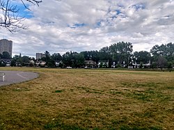
Westwood Park, Ottawa.jpg
Westwood Park
Newottawamap.png
Red pog.svg
Carlingwood
Coordinates: 45°22′34″N75°46′09″W / 45.37617°N 75.76907°W / 45.37617; -75.76907 Coordinates: 45°22′34″N75°46′09″W / 45.37617°N 75.76907°W / 45.37617; -75.76907
CountryCanada
Province Ontario
City Ottawa
Government
   MPs Anita Vandenbeld
   MPPs Chandra Pasma
   Councillors Theresa Kavanagh
  Governing bodyCarlingwood Community Association
Area
  Total0.779 km2 (0.301 sq mi)
Elevation
70 m (230 ft)
Population
  Total3,558
  Density4,600/km2 (12,000/sq mi)
Time zone Eastern (EST)
Forward sortation area
K2A
Website Carlingwood Community Association

Carlingwood [1] is a neighbourhood in Bay Ward in the west end of Ottawa, Ontario, Canada. The neighbourhood is roughly bounded on the north by Richmond Road, on the east by Sherbourne Road, on the south by Carling Avenue and on the west by Woodroffe Avenue. This area corresponds to census tract 5050032.01, which had a population of 3,558 according to the Canada 2016 Census. [2]

The Carlingwood Shopping Centre was built in 1956 at the corner of Carling and Woodroffe. The surrounding neighbourhood would be built later in the decade. [3] Somserset Towers and the Saville Apartments (then known as Saville Terrace) [4] were built in the early 1960s, and Bromley Square was built in the early 1970s.

Carlingwood is home to two parks, Westwood and Woodroffe, the latter of which has a play structure, wading pool, and temporary hockey rink (in winter). Byron Linear Tramway Park is located nearby. It is also home of Woodroffe Avenue Public School, Our Lady of Fatima School and the Ottawa Public Library Carlingwood Branch. Churches in Carlingwood include Our Lady of Fatima Catholic, Ukrainian Orthodox Cathedral Assumption Of The Blessed Virgin, Woodroffe United, St. Martin's Anglican, and Bromley Road Baptist. During the summer, Shouldice Berry Farms operates a stand at the corner of Byron and Woodroffe.

Carlingwood is also the home to the soon-to-come Sherbourne station in the Ottawa Confederation Line West Extension, to come in 2025. OC Transpo routes 51, 11, 85, and 87 pass through it or on a nearby major road.

Related Research Articles

<span class="mw-page-title-main">Westboro, Ottawa</span> Neighbourhood in Ottawa, Ontario, Canada

Westboro is an area in the west end of Ottawa, Ontario, Canada. Located along the Ottawa River, Island Park Drive defines Westboro's eastern border, while the Ottawa River defines its northern border. Under this definition, the population of the area is 22,725.

<span class="mw-page-title-main">Carling Avenue</span> Major arterial road linking both ends of Ottawa, Ontario

Carling Avenue is a major east–west arterial road in the west end of Ottawa, Ontario, Canada. It runs from March Road in Kanata to Bronson Avenue in the Glebe. The road is named for John Carling, founder of Carling Brewery and Conservative MP and Senator, Postmaster General and Minister of Agriculture.

<span class="mw-page-title-main">Centrepointe</span> Neighbourhood in Ottawa, Ontario, Canada

Centrepointe is a neighbourhood in College Ward in the west end of the city of Ottawa, Ontario, Canada. It was formerly part of the city of Nepean. It is a newer residential subdivision in the west/central part of Ottawa, developed from 1984 onwards, and is informally bounded by Baseline Road to the north, Woodroffe Avenue to the east, the CN railroad to the south, and the Briargreen subdivision and Forest Ridge Apartments to the west. The housing stock includes approximately 1,000 detached homes, with the remainder mostly townhomes and terrace homes.

<span class="mw-page-title-main">Woodroffe Avenue</span> Road in Ottawa, Ontario, Canada

Woodroffe Avenue is a major north-south arterial road in Ottawa, Ontario, Canada's west end. It runs south from the Sir John A. Macdonald Parkway through Baseline Road and Barrhaven to just short of Prince of Wales Drive near Manotick. The road runs through the heart of Nepean in Ottawa's west end. A satellite Via Rail station is also located at the intersection of Fallowfield Road.

<span class="mw-page-title-main">Bells Corners</span> Community in Ontario, Canada

Bells Corners is a suburban neighbourhood in Ottawa, Ontario, Canada. It is located along Richmond Road west of downtown, within Ottawa's western Greenbelt, in College Ward. As of the Canada 2016 Census, the community had a population of 9,272.

<span class="mw-page-title-main">Glabar Park</span> Neighbourhood in Ottawa, Ontario, Canada

Glabar Park is a neighbourhood in Bay Ward, in the west end of Ottawa, Ontario, Canada. It is bounded on the west by Woodroffe Avenue north by Carling Avenue, south by The Queensway and on the east by Maitland Avenue. The population at the 2011 census was about 2,806.

<span class="mw-page-title-main">Lincoln Heights, Ottawa</span> Neighbourhood in Ottawa, Ontario, Canada

Lincoln Heights is a neighbourhood in the Britannia area of Bay Ward in the west end of Ottawa, Ontario, Canada. It is defined by its community association as being bounded to the south by the north side of Regina Lane, to the north by the Ottawa River, to the west by the east side of Croydon Avenue, and to the east by the Ottawa River Parkway. According to the Canada 2016 Census, the population of the neighbourhood is 1,630. The greater Lincoln Heights area can be defined as extending as far west as Greenview Avenue and as far south as Carling Avenue, which overlaps with neighbouring Britannia Village.

<span class="mw-page-title-main">Meadowlands Drive</span>

Meadowlands Drive is a suburban road in Ottawa, Ontario, Canada. It begins at Prince of Wales Drive as a continuation of Hog's Back Road in the neighborhood of Rideauview. There are two small shopping plazas and a Shell station at its corner with Prince of Wales. It then continues westward towards Fisher Avenue and consists of low-income housing projects, low-rise apartment buildings, townhouses and semi-detached homes. The speed limit here is 50 km/h (31 mph). most of Meadowlands is one lane, other than between Prince of Wales to Fisher, and from Chesterton to Merivale.

<span class="mw-page-title-main">Carlingwood Mall</span> Shopping mall in Ontario, Canada

Carlingwood Shopping Centre is shopping mall located in the Carlingwood neighbourhood of Ottawa, Ontario, Canada. The mall opened in 1956 and was one of the city's first major shopping centres. Since January 2021, it has been operated by Strathallen Property Management.

<span class="mw-page-title-main">Crystal Beach, Ottawa</span> Neighbourhood in Ottawa, Ontario, Canada

Crystal Beach is a neighbourhood in Ottawa, Ontario, Canada. It is located in the west end of Ottawa, in Bay Ward. The neighbourhood is triangular in shape, and its boundaries can broadly be described as Carling Avenue to the northeast, Moodie Drive to the west, and Corkstown Road to the south. It is. According to the Canada 2011 Census, the total population of the neighbourhood was 2,416.

<span class="mw-page-title-main">Woodroffe North</span> Neighbourhood in Ottawa

Woodroffe North is a neighbourhood in Bay Ward in the west end of Ottawa, Ontario, Canada. It is bounded on the south by Richmond Road on the west by the Sir John A. Macdonald Parkway, on the north by the Ottawa River and on the east by the northern prolongation of Sherbourne Avenue. Woodroffe North has also been referred to as a community within the neighbourhood of Westboro which claims its western border to be Woodroffe Avenue. The Woodroffe North Community includes residents that live on streets West of Woodroffe Avenue. Originally the homes used to be cottages similar to those in Britannia. Most of the cottages were demolished and changed into houses. Lockhart Avenue is split up at Richmond Road and continues at Byron and ends at Saville Row in front of Carlingwood.

<span class="mw-page-title-main">Carlington</span> Neighbourhood in Ottawa, Ontario, Canada

Carlington is a neighbourhood located in River Ward in the west-end of Ottawa, Ontario, Canada.

Qualicum-Graham Park or Qualicum is a suburban neighbourhood in College Ward in the City of Ottawa, Ontario, Canada. It is located in the former City of Nepean in the west end of the city. Many of the residences in the area are executive homes situated on large lots (100x100) being built in the 1960s. Qualicum Street boasts large custom houses built by Bill Teron. The neighbourhood is bounded to the north by the Queensway, to the west by Richmond Road, to the south by Baseline Road, and to the east by Morrison Drive at the former Ottawa-Nepean border towards Redwood. Named after Qualicum Beach in British Columbia.

<span class="mw-page-title-main">Central Park, Ottawa</span> Neighbourhood in Ottawa, Ontario, Canada

Central Park is a neighbourhood in River Ward in the west end of Ottawa, Ontario, Canada. It is bounded on the east by Merivale Road, on the south by Baseline Road, on the west by Clyde Avenue and on the north by the Carlington neighbourhood. The population of the neighbourhood in 2016 was 3,888 in an area of 0.91 km2. It more than doubled its population between 2001 and 2006 as the neighbourhood expanded. Excluding the residences south of Baseline which are included in the Census Tract, the population of the neighbourhood is 3,760.

Woodpark is a small neighbourhood in Bay Ward, in the west end of Ottawa, Ontario, Canada. It is bounded in the north by Richmond Road, to the East by Woodroffe Avenue north, in the South by Carling Avenue and in the west by the Sir John A. Macdonald Parkway. The total population of the neighbourhood according to the Canada 2016 Census was 2,191.

<span class="mw-page-title-main">Carleton Heights</span> Neighbourhood in Ottawa, Ontario, Canada

Carleton Heights is a neighbourhood in River Ward in Ottawa, Ontario, Canada. According to the Carleton Heights and Area Community Association, the neighbourhood is bounded on the north by the Central Experimental Farm, on the east by the Rideau River, on the south by the junction of Prince of Wales Drive and Fisher Avenue and on the west by Fisher Avenue. The neighbourhood is sometimes referred to as Hog's Back after the nearby falls. The total population of the neighbourhood is 7,586 according to the Canada 2016 Census.

<span class="mw-page-title-main">McKellar Heights</span> Neighbourhood in Ottawa, Ontario, Canada

McKellar Heights is a small neighbourhood located in Kitchissippi Ward, in the west end of Ottawa, Ontario, Canada. The neighbourhood is generally triangular in shape, and is generally bounded on the north by Westboro, on the west by Glabar Park, and on the south by Carlington. The population as of the Canada 2016 Census was 575.

Lynwood Village is a neighbourhood in Bells Corners, west of Ottawa, Ontario, Canada. The neighbourhood is also known as Bells Corners East. The homes were built in between 1958 and 1966. It is one of the first examples of tract housing in Ottawa. The neighbourhood is bounded to the north Robertson Road, east is presumably Highway 416, south by Hunt Club Road, and the west is Moodie Drive.

Queensway Terrace North (QTN) is a neighbourhood in Bay Ward in the west end of Ottawa, Ontario, Canada. Its neighbourhood association is bounded to the north by Carling Avenue, to the west by Pinecrest Road, to the south by the Queensway, and to the east by the Transitway. These boundaries include the adjacent neighbourhood of Britannia Heights.

<span class="mw-page-title-main">Byron Linear Tramway Park</span> Park in Ottawa, Canada

Byron Linear Tramway Park is a municipal park in Kitchissippi Ward and Bay Ward in Ottawa, Ontario, Canada. The park forms a narrow strip of park land that runs westward from Holland Avenue to Richardson Avenue in Woodpark, with the exception of Westboro Village. Running through the entirety of the park is a path through grass and trees. The park forms a narrow 2.5 km strip, but has a width varies between 5 and 15 metres.

References

  1. "Carlingwood". Geographical Names Data Base . Natural Resources Canada.
  2. "Census Profile, 2016 Census - 5050032.01 [Census tract], Ontario and Canada [Country]". 8 February 2017.
  3. GeoOttawa areal maps - 1958
  4. "Saville Terrace". Ottawa Citizen. August 26, 1963. Retrieved July 18, 2020.