Belltown, Ottawa

Last updated

Belltown
Neighbourhood
BelltownDome.jpg
Belltown Dome
Newottawamap.png
Red pog.svg
Belltown
Location within Ottawa
Coordinates: 45°21′38″N75°48′08″W / 45.36056°N 75.80222°W / 45.36056; -75.80222
CountryCanada
Province Ontario
City Ottawa
Government
   MPs Anita Vandenbeld
   MPPs Jeremy Roberts
   Councillors Theresa Kavanagh
  Governing bodyBelltown Neighbourhood Association
  President Alex Cullen [1]
Area
  Total0.777 km2 (0.300 sq mi)
Elevation
60 m (200 ft)
Population
 (2016)
  Total2,089
  Density2,700/km2 (7,000/sq mi)
  Canada 2016 Census
Time zone UTC-5 (Eastern (EST))

Belltown is a neighbourhood in the Britannia area of Bay Ward, in the west end of Ottawa. It is bounded on the east by Britannia Park, on the north by the Ottawa River, on the west by Andrew Haydon Park and the south by Carling Avenue. [2] Prior to Ottawa's amalgamation in 2001, the neighbourhood spanned the Ottawa-Nepean municipal boundary. The neighbourhood's population is 2089 (2016 Census), with 294 people living in the Nepean portion. [3]

Contents

History

The neighbourhood began to be built in the early 1920s [4] with additions in the late 1940s. [5] It was part of Nepean Township until most of the area was annexed by Ottawa in 1950. In its early years, the neighbourhood was a "cottage community". [6]

In 1963, the eastern part of the neighbourhood received sewers for the first time, replacing the use of septic tanks. At the same time, parts of the neighbourhood faced expropriation to make room for the proposed "Pinecrest-Deschenes Freeway" which was never built. [7]

In 1968, the Britannia Woods housing development was completed in the neighbourhood for placement of families in to rent-to-income units. Britannia Woods is owned by Ottawa Community Housing. [8] It was built by Catkey Construction and financed by the Ontario Housing Corporation. [9]

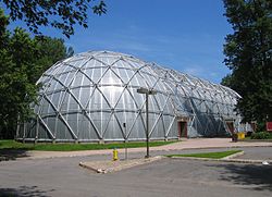
In 1975, residents approved a grant of over $2 million as part of the Neighbourhood Improvement Program (NIP) to "rehabilitate and preserve" the neighbourhood. The NIP was a federal-provincial-municipal plan to improve and preserve old neighbourhoods and encourage development of the community's environment. [10] The money mostly went toward storm sewer and road construction, and a multi-use recreation facility, plus street lighting, water-front development, playgrounds, tree planting and traffic light installation. [11] The grant would pay for the Belltown Dome hockey arena, [12] a geodesic dome-shaped building, which officially opened in 1979. [13] In 1979, Nepean City Council approved a $250,000 for improvements in the Nepean section of the neighbourhood, for the creation of a park, an additional sewer and street upgrades. [14]

One issue that continued to threaten the community's character was the proposed "Britannia Parkway", which would have run along the Ottawa River connecting the Kichi Zibi Mikan to the Queensway. [15] The parkway was never built. Today, the neighbourhood is threatened by being within the Ottawa River's floodplain. [16]

Amenities

In addition to Britannia Park, which forms the neighbourhood's eastern border, and Andrew Haydon Park which forms the western border, Belltown also contains Grandeur Park. Municipal facilities include the Belltown Dome Arena, the Ron Kolbus Lakeside Centre and Briannia Trolley Park. The neighbourhood contains one school, Dr. F.J. McDonald Catholic. The Briannia Woods project includes a community garden. [16]

The Trans Canada Trail (left) and Grandeur Avenue (right) in Belltown Grandeur Avenue, Belltown, Ottawa.jpg
The Trans Canada Trail (left) and Grandeur Avenue (right) in Belltown

Related Research Articles

<span class="mw-page-title-main">Nepean, Ontario</span> Former municipality in Ontario, Canada

Nepean is a former municipality and now geographic area of Ottawa, Ontario, Canada. Located west of Ottawa's inner core, it was an independent city until amalgamated with the Regional Municipality of Ottawa–Carleton in 2001 to become the new city of Ottawa. However, the name Nepean continues in common usage in reference to the area. The population of Nepean is about 186,593 people.

<span class="mw-page-title-main">Heron Gate</span> Neighbourhood in Ottawa, Ontario, Canada

Heron Gate or Herongate is a neighbourhood in Alta Vista Ward and Gloucester-Southgate Ward in the south end of Ottawa, Ontario, Canada. It is defined by the Herongate Tenant Coalition as being bounded on the north by Heron Road, on the west by Heron-Walkley Park and Albion Road, and by the Walkley rail corridor on the south. The total population for this area according to the Canada 2016 Census was 9,714.

<span class="mw-page-title-main">Mechanicsville, Ottawa</span> Neighbourhood in Ottawa, Ontario, Canada

Mechanicsville is a neighbourhood in Kitchissippi Ward in central Ottawa, Ontario, Canada. It is located to the west of downtown and bordered by the Ottawa River to the north, the O-Train Trillium Line to the east, Scott Street to the south, and Parkdale Avenue to the west. East of Mechanicsville is LeBreton Flats, Tunney's Pasture is directly west, and Hintonburg is to the south. The total population of the neighbourhood as of the 2011 Census was 2,205.

<span class="mw-page-title-main">LeBreton Flats</span> Neighbourhood in Ottawa, Ontario, Canada

LeBreton Flats known colloquially as The Flats is a neighbourhood in Somerset Ward in central Ottawa, Ontario, Canada. It lies to the west of Centretown neighbourhood, and to the north of Centretown West. The Ottawa River forms the western and northern limit, with the western side being a wider area of the river known as Nepean Bay.

<span class="mw-page-title-main">Britannia, Ottawa</span> Neighbourhood in Ottawa, Ontario, Canada

Britannia is a group of neighbourhoods in Bay Ward in the west end of Ottawa, Ontario, Canada. It is located on the Ottawa River across from Aylmer, Quebec, adjacent to its namesake, Britannia Bay, north of Richmond Road, west of the Kichi Zibi Mikan and east of Boyce Avenue. The total population of this area was 6,692 as of the 2016 census. The area constituted a municipal ward from 1973 to 1994.

<span class="mw-page-title-main">Alta Vista, Ottawa</span> Neighbourhood in Ottawa, Ontario, Canada

Alta Vista is a neighbourhood in Alta Vista Ward in Ottawa, Ontario, Canada. Its boundaries according to the Alta Vista Community Association are that part of Alta Vista Ward south of Smyth Road in the north, north of Walkley Road and east of the Rideau River, and west of the "greenspace underneath Haig Drive". However, the name is ambiguous, as there are several sub-neighbourhoods in this area,, as the neighbourhood could refer to the ward as a whole, down to the core Alta Vista area,, centred on Alta Vista Drive.

<span class="mw-page-title-main">Bells Corners</span> Community in Ontario, Canada

Bells Corners is a suburban neighbourhood in Ottawa, Ontario, Canada. It is located along Robertson Road west of downtown, within Ottawa's western Greenbelt, in College Ward. As of the Canada 2016 Census, the community had a population of 9,272.

<span class="mw-page-title-main">Manor Park, Ottawa</span> Neighbourhood in Ottawa, Ontario, Canada

Manor Park is a neighbourhood in Rideau-Rockcliffe Ward in the east end of Ottawa, Ontario, Canada on the east side of Rockcliffe Park.

<span class="mw-page-title-main">Lincoln Heights, Ottawa</span> Neighbourhood in Ottawa, Ontario, Canada

Lincoln Heights is a neighbourhood in the Britannia area of Bay Ward in the west end of Ottawa, Ontario, Canada. It is defined by its community association as being bounded to the south by the north side of Regina Lane, to the north by the Ottawa River, to the west by the east side of Croydon Avenue, and to the east by the Kichi Zibi Mikan. According to the Canada 2016 Census, the population of the neighbourhood is 1,630. The greater Lincoln Heights area can be defined as extending as far west as Greenview Avenue and as far south as Carling Avenue, which overlaps with neighbouring Britannia Village.

<span class="mw-page-title-main">Crystal Beach, Ottawa</span> Neighbourhood in Ottawa, Ontario, Canada

Crystal Beach is a neighbourhood in Ottawa, Ontario, Canada. It is located in the west end of Ottawa, in Bay Ward. The neighbourhood is triangular in shape, and its boundaries can broadly be described as Carling Avenue to the northeast, Moodie Drive to the west, and Corkstown Road to the south. It is. According to the Canada 2011 Census, the total population of the neighbourhood was 2,416.

<span class="mw-page-title-main">2010 Ottawa municipal election</span> Election in Canada

The 2010 Ottawa municipal election was a municipal election that was held on October 25, 2010, to elect the mayor of Ottawa, Ottawa City Council and the Ottawa-Carleton Public and Catholic School Boards. The election was held on the same date as elections in every other municipality in Ontario.

<span class="mw-page-title-main">Heron Park</span> Neighbourhood in Ottawa, Ontario, Canada

Heron Park is a neighbourhood in Capital Ward in Ottawa, Ontario, Canada. Its boundaries are the Rideau River to the north, the Sawmill Creek to the west, Bank Street to the east and Walkley Road to the south.

<span class="mw-page-title-main">Carleton Heights</span> Neighbourhood in Ottawa, Ontario, Canada

Carleton Heights is a neighbourhood in River Ward in Ottawa, Ontario, Canada. According to the Carleton Heights and Area Community Association, the neighbourhood is bounded on the north by the Central Experimental Farm, on the east by the Rideau River, on the south by the junction of Prince of Wales Drive and Fisher Avenue and on the west by Fisher Avenue. The neighbourhood is sometimes referred to as Hog's Back after the nearby falls. The total population of the neighbourhood is 7,586 according to the Canada 2016 Census.

<span class="mw-page-title-main">Ellwood, Ottawa</span> Neighbourhood in Ottawa, Ontario, Canada

Ellwood is a neighbourhood and former railway point in River Ward, in the south end of Ottawa, Ontario, Canada. It is bounded by Walkley Road on the north, the Transitway on the west, Albion Road on the east, and Ledbury Park on the south. The population of this area is approximately 2908.

<span class="mw-page-title-main">Foster Farm</span> Neighbourhood in Ottawa, Ontario, Canada

Foster Farm, nicknamed "the Farm", is a neighbourhood in the Britannia area of Bay Ward in the west end of Ottawa, Ontario, Canada. It is roughly bounded to the north by Richmond Road, to the east by Pinecrest Road, to the west by the former Ottawa/Nepean city limits and the south by the Highway 417, the Queensway. It is bordered by Fairfield Heights, Queensway Terrace North, Redwood, Michele Heights. The total population of this area according to the 2016 Canada Census was 3,636.

<span class="mw-page-title-main">Cyrville</span> Neighbourhood in Ottawa, Ontario, Canada

Cyrville is a neighbourhood in Beacon Hill-Cyrville Ward in the east-end of Ottawa, Ontario, Canada. The area is located within the former City of Gloucester, and is roughly bounded on the north, west and south by the former Gloucester City limit, and on the east by the Aviation Parkway and Highway 417. Once a francophone farming village, the area now a mix of residential and industrial land, being home to the Cyrville Industrial Area. It has been described as a "tangle of freeways and utility corridors". It has a population of 4513, 280 of which live south of the Queensway.

<span class="mw-page-title-main">Britannia United Church</span> Church in Ottawa, Ontario

Britannia United Church is a United Church of Canada congregation in Ottawa, Ontario, Canada. One of Ottawa's oldest congregations, members had been meeting in homes since 1869. The Britannia Heights Methodist Church formed in 1873. It joined the United Church when it was formed in 1925. In 1925, Britannia became officially Britannia United Church. The Britannia United Church has operated out of Pinecrest Road location since 1961.

<span class="mw-page-title-main">Porter Island</span> Island in Rideau River, Ontario, Canada

Porter Island is an island in the Rideau River, located just over 1 km from the mouth of the river, between the neighbourhoods of New Edinburgh and Lower Town in Ottawa, Ontario, Canada.

References

  1. "BNA Executive - Belltown Neighbourhood Association".
  2. Belltown Neighbourhood Association Facebook
  3. Population calculated by combining the populations of dissemination areas 35060647, 35060649, 35060648, 35061390 (Nepean portion) and dissemination block 35061289003
  4. Ottawa, Ontario. 1:63,360. Map Sheet 031G05, [ed. 7], 1925; Producer: Geographical Section, General Staff, Department of National Defence; Date published: 1925-01-01 (publication), 2016-01-01 (publication)
  5. Ottawa, Ontario. 1:63,360. Map Sheet 031G05, [ed. 17], gridded, 1948; Producer: Geographical Section, General Staff, Department of National Defence; Date published: 1948-01-01 (publication), 2016-01-01 (publication); Type of data layer: Raster, Not specified
  6. "Massive renewal planned". Ottawa Citizen. February 9, 1976. Retrieved June 25, 2020.
  7. "Belltown expropriation thorny question". Ottawa Citizen. March 8, 1963. Retrieved June 25, 2020.
  8. "Rentals in Britannia Woods - Ottawa Community Housing".
  9. "Housing Development Nears Completion". Ottawa Journal. September 25, 1968. Retrieved June 25, 2020.
  10. "Belltowners okay improvement loans". Ottawa Citizen. August 1, 1975. Retrieved June 25, 2020.
  11. "Belltown Area Gets $2 Million". Ottawa Journal. June 18, 1976. Retrieved June 25, 2020.
  12. "Under the dome". Ottawa Journal. January 22, 1978. Retrieved June 25, 2020.
  13. "Efforts pay off under the dome". Ottawa Citizen. January 22, 1979. Retrieved June 25, 2020.
  14. "$125,000 facelift for Belltown". Ottawa Citizen. December 12, 1979. Retrieved June 25, 2020.
  15. "Britannia/ Parkway extension opposed". Ottawa Citizen. October 10, 1984. Retrieved June 25, 2020.
  16. 1 2 https://maps.ottawa.ca/geoottawa/ GeoOttawa