Riverview is a neighbourhood in Ottawa, Ontario, Canada. It is southeast of the downtown adjacent to the Rideau River, its location on which is its namesake. The 2021 Census population of Riverview is 13,113.

Agincourt is a neighbourhood and former village in Toronto, Ontario, Canada. Agincourt is located in northeast Toronto, along Sheppard Avenue between Kennedy and Markham Roads. Before the creation of the "megacity" of Toronto in 1998, the area was part of Scarborough. It is officially recognized by the City of Toronto as occupying the neighbourhoods of Agincourt South–Malvern West and Agincourt North.

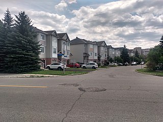
Centrepointe is a neighbourhood in College Ward in the west end of the city of Ottawa, Ontario, Canada. It was formerly part of the city of Nepean. It is a newer residential subdivision in the west/central part of Ottawa, developed from 1984 onwards, and is informally bounded by Baseline Road to the north, Woodroffe Avenue to the east, the CN railroad to the south, and the Briargreen subdivision and Forest Ridge Apartments to the west. The housing stock includes approximately 1,000 detached homes, with the remainder mostly townhomes and terrace homes.
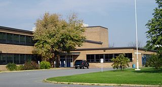
Laurentian High School was a high school in the Central Park neighbourhood of Ottawa, Ontario, Canada. The school opened in 1958 and provided education to grade 9 through 12 through an unsemestered curriculum as established by the Ontario Ministry of Education.

Bells Corners is a suburban neighbourhood in Ottawa, Ontario, Canada. It is located along Robertson Road west of downtown, within Ottawa's western Greenbelt, in College Ward. As of the Canada 2016 Census, the community had a population of 9,272.

Meadowlands Drive is a suburban road in Ottawa, Ontario, Canada. It begins at Prince of Wales Drive as a continuation of Hog's Back Road in the neighborhood of Rideauview. There are two small shopping plazas and a Shell station at its corner with Prince of Wales. It then continues westward towards Fisher Avenue and consists of low-income housing projects, low-rise apartment buildings, townhouses and semi-detached homes. The speed limit here is 50 km/h (31 mph). most of Meadowlands is one lane, other than between Prince of Wales to Fisher, and from Chesterton to Merivale.

Tam O'Shanter-Sullivan is a neighbourhood in the east end of the city of Toronto, Ontario, Canada, in the district of Scarborough. The neighbourhood is bordered by Huntingwood Drive to the North, Kennedy Road to the East, Highway 401 to the South and Victoria Park to the West. The neighbourhood, which includes the Tam O'Shanter and Sullivan communities, takes its name from Tam O’Shanter Golf Course and O'Sullivan's Corners.

Crystal Beach is a neighbourhood in Ottawa, Ontario, Canada. It is located in the west end of Ottawa, in Bay Ward. The neighbourhood is triangular in shape, and its boundaries can broadly be described as Carling Avenue to the northeast, Moodie Drive to the west, and Corkstown Road to the south. It is. According to the Canada 2011 Census, the total population of the neighbourhood was 2,416.

High Park North, or often simply High Park, after the park, is a neighbourhood in Toronto, Ontario, Canada. It is bounded on the south by Bloor Street, on the west by Runnymede Road, on the north by Annette Street, Quebec Avenue and Humberside Avenue, and on the east by the GO Transit Weston Subdivision rail tracks. It is located in the Parkdale—High Park provincial and federal electoral districts. The area east of Keele Street is also known informally as the "West Bend" neighbourhood.
Qualicum-Graham Park or Qualicum is a suburban neighbourhood in College Ward in the City of Ottawa, Ontario, Canada. It is located in the former City of Nepean in the west end of the city. Many of the residences in the area are executive homes situated on large lots (100x100) being built in the 1960s. Qualicum Street boasts large custom houses built by Bill Teron. The neighbourhood is bounded to the north by the Queensway, to the west by Richmond Road, to the south by Baseline Road, and to the east by Morrison Drive at the former Ottawa-Nepean border towards Redwood. Named after Qualicum Beach in British Columbia.
Leslie Park is a suburban neighbourhood in College Ward in the city of Ottawa, Ontario, Canada. It is located in the former city of Nepean.
Central Park is a neighbourhood in River Ward in the west end of Ottawa, Ontario, Canada. It is bounded on the east by Merivale Road, on the south by Baseline Road, on the west by Clyde Avenue and on the north by the Carlington neighbourhood. The population of the neighbourhood in 2016 was 3,888 in an area of 0.91 km2. It more than doubled its population between 2001 and 2006 as the neighbourhood expanded. Excluding the residences south of Baseline which are included in the Census Tract, the population of the neighbourhood is 3,760.
Skyline is a neighbourhood in Knoxdale-Merivale Ward in Ottawa, Ontario, Canada. Prior to amalgamation in 2001, the neighbourhood was located in the City of Nepean. It is bounded on the south by Meadowlands Drive of Parkwood Hills, on the west by Clyde Avenue and Merivale Road, on the north by Baseline Road and on the east by the neighbourhood of Fisher Heights.

Fisher Heights is a neighbourhood located in the far northeast corner of the former City of Nepean in Ottawa, Ontario, Canada. It is located in Knoxdale-Merivale Ward. The area is located south of the Experimental Farm and approximately 8 km away from downtown Ottawa.
Courtland Park is a sub-neighbourhood of Carleton Heights in River Ward in the west end of Ottawa, Ontario, Canada. It is bounded on the north by Baseline Road, on the east by the Rideau River, on the south by Dynes Road and on the west by Fisher Avenue. Prince of Wales Drive runs thorough the neighbourhood.

Bel-Air Heights is a neighbourhood in College Ward in the west end of Ottawa, Ontario, Canada. It is bounded on the east by Agincourt Road, on the south by Baseline Road, on the west by Navaho Drive and on the north by the Central Experimental Farm Pathway. The neighbourhood is mostly a middle class housing neighbourhood.

Bel-Air Park is a neighbourhood in College Ward in the west end of Ottawa, Ontario, Canada. It is bounded on the east by the Experimental Farm Pathway, on the south by Baseline Road, on the west by Woodroffe Avenue and on the north by the Queensway.
Braemar Park is a neighbourhood in College Ward in the west end of Ottawa, Ontario, Canada. It is bounded on the north by the Queensway, east on Maitland Drive, south by the Central Experimental Pathway and west by J. H. Putman Public School.

