Related Research Articles
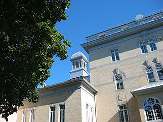
Old Ottawa South is an older urban neighbourhood in Capital Ward in Ottawa, Ontario, Canada. Old Ottawa South is a relatively small and compact neighbourhood, located between the Rideau Canal and the Rideau River. The eastern boundary is Avenue Road. Bronson Avenue forms the western border of the residential neighbourhood. Carleton University is on the other (western) side of Bronson but the campus can be considered to be geographically within Old Ottawa South as the campus is also nestled between the river and the canal.

Ottawa West—Nepean is a federal electoral district in Ontario, Canada, that has been represented in the House of Commons of Canada since 1997.

Ottawa Centre is an urban federal electoral district in Ontario, Canada, that has been represented in the House of Commons of Canada since 1968. While the riding's boundaries have changed over the years to account for population changes, the riding has always comprised the central areas of Ottawa, the nation's capital.

Ottawa South is a federal electoral district in Ottawa, Ontario, Canada. It is represented in the House of Commons of Canada by David McGuinty, brother of former Premier of Ontario and Ottawa South MPP Dalton McGuinty. It has been held continuously by Liberal candidates since it was first contested in 1988, and is regarded as one of the strongest Liberal ridings in Canada. Ottawa South is a suburban, generally middle class riding, notable for having the highest Arab population in Ontario.
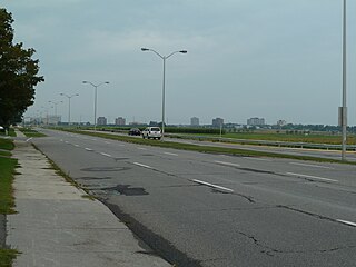
Baseline Road is a road in Ottawa, Ontario, Canada.

Barrhaven is a suburb of Ottawa, Ontario, Canada. It is located about 17 km (11 mi) southwest of the city's downtown core. Prior to amalgamation with Ottawa in 2001, Barrhaven was part of the City of Nepean. Its population as of the Canada 2021 Census was 103,234.

Carleton is a federal electoral district in Ontario, Canada, represented in the House of Commons of Canada from 1867 to 1968 and since 2015. It was represented in the Legislative Assembly of Upper Canada from 1821 to 1840 and in the Legislative Assembly of the Province of Canada from 1841 until 1866. It has been represented by Pierre Poilievre, the current Leader of the Opposition, since its creation in 2015.
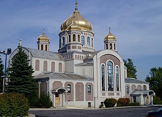
St. John the Baptist Ukrainian Catholic National Shrine is a prominent Ukrainian Catholic church in Ottawa, Ontario, Canada.

Rideau View is a sub-neighbourhood of Carleton Heights in River Ward, in the west-end of Ottawa, Ontario, Canada, located near the Rideau River. It is bordered by Meadowlands Drive to the south, Claymor Avenue to the west and Dynes Road to the north. Debra Avenue is the main road that runs through the neighbourhood and there is some residential housing on Eiffel Avenue. Some of parts of the neighbourhoods are east of Prince of Wales Drive and runs parallel along the Rideau River. The area is also located close to the former city of Nepean. A major feature of the neighbourhood is a low-income housing project designed and built by the Ottawa Housing corporation. There are four high-rise condominiums on Prince of Wales at the corner of Dynes and Meadowlands.

The Dominion Arboretum is an arboretum part of the Central Experimental Farm of Agriculture and Agri-Food Canada in Ottawa, Ontario, Canada. Originally begun in 1889, the Arboretum covers about 26 hectares of rolling land between Prince of Wales Drive, Dow's Lake and the Rideau Canal. Carleton University is located at the opposite side of the Canal. At a latitude of 45°, it can experience extremely hot and humid summers and extremely cold winters.

Meadowlands Drive is a suburban road in Ottawa, Ontario, Canada. It begins at Prince of Wales Drive as a continuation of Hog's Back Road in the neighborhood of Rideauview. There are two small shopping plazas and a Shell station at its corner with Prince of Wales. It then continues westward towards Fisher Avenue and consists of low-income housing projects, low-rise apartment buildings, townhouses and semi-detached homes. The speed limit here is 50 km/h (31 mph). most of Meadowlands is one lane, other than between Prince of Wales to Fisher, and from Chesterton to Merivale.
Ottawa Centre is an urban provincial electoral district in Ontario, Canada that has been represented in the Legislative Assembly of Ontario since 1968. While the riding's boundaries have changed over the years to account for population changes, the riding has always comprised the central areas of Ottawa, the nation's capital.
Prince of Wales on the Rideau is an affluent neighbourhood in Carleton Heights, River Ward, and Wellsmere Court in the west-end of Ottawa, Ontario, Canada. It consists of 210 homes on a peninsula between the Rideau River and Prince of Wales Drive, on the west shore of Mooney's Bay.
Qualicum-Graham Park or Qualicum is a suburban neighbourhood in College Ward in the City of Ottawa, Ontario, Canada. It is located in the former City of Nepean in the west end of the city. Many of the residences in the area are executive homes situated on large lots (100x100) being built in the 1960s. Qualicum Street boasts large custom houses built by Bill Teron. The neighbourhood is bounded to the north by the Queensway, to the west by Richmond Road, to the south by Baseline Road, and to the east by Morrison Drive at the former Ottawa-Nepean border towards Redwood. Named after Qualicum Beach in British Columbia.
Courtland Park is a sub-neighbourhood of Carleton Heights in River Ward in the west end of Ottawa, Ontario, Canada. It is bounded on the north by Baseline Road, on the east by the Rideau River, on the south by Dynes Road and on the west by Fisher Avenue. Prince of Wales Drive runs thorough the neighbourhood.

Confederation Heights is an area in south Ottawa, Canada, made up of mostly government buildings. It is bounded on the east by Data Centre Road, on the north and west by the Rideau River and on the south by Brookfield Road.

Carleton Heights is a neighbourhood in River Ward in Ottawa, Ontario, Canada. According to the Carleton Heights and Area Community Association, the neighbourhood is bounded on the north by the Central Experimental Farm, on the east by the Rideau River, on the south by the junction of Prince of Wales Drive and Fisher Avenue and on the west by Fisher Avenue. The neighbourhood is sometimes referred to as Hog's Back after the nearby falls. The total population of the neighbourhood is 7,586 according to the Canada 2016 Census.
Country Place is a residential neighbourhood near the geographical centre of Ottawa, Canada, in Knoxdale-Merivale Ward. Prior to 2001, it was part of the former city of Nepean. It is a mature residential subdivision with about 400 houses located just inside the Ottawa greenbelt near the Rideau River, and about 11 km from downtown Ottawa. It is bordered by the Black Rapids Creek and the greenbelt to the south, Prince of Wales Drive to the east, Merivale Road to the west, and the Pineglen community to the north. Amberwood Crescent meanders through the community, exiting onto Prince of Wales and Merivale. Tennyson Drive links Country Place to Pineglen.
References
- ↑ Census Block 3506106740
45°22′44″N75°42′15″W / 45.3789°N 75.7043°W
| | This article relating to Ottawa and to Canada's National Capital Region is a stub. You can help Wikipedia by expanding it. |