Cumberland is a former municipality and now geographic township in eastern Ontario, Canada. It was an incorporated township from 1800 to 1999, when it was incorporated as the City of Cumberland, then ceased to be a separate municipality in 2001, when it was amalgamated into the city of Ottawa. It now exists only as a geographic township.

Ottawa—Vanier is a federal electoral district in Ontario, Canada, that has been represented in the House of Commons of Canada since 1935. Previous to that date, it was part of the Ottawa electoral district that returned two members.

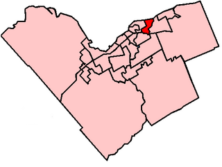
Orléans is a federal electoral district in Ottawa, Ontario, Canada, that has been represented in the House of Commons of Canada since 1988.

Beacon Hill is a neighbourhood located in Beacon Hill-Cyrville Ward in the east end of Ottawa, Ontario, Canada. Beacon Hill was a part of the City of Gloucester until it was amalgamated with the new city of Ottawa in 2001.

Orleans is a community in Ottawa, Ontario, Canada. It is located in the east end of the city along the Ottawa River, about 16 km (10 mi) from Downtown Ottawa. The Canada 2021 Census determined that Orléans' population was 125,937. Before being amalgamated into Ottawa in 2001, the community of Orléans was spread over two municipal jurisdictions, the eastern portion being in the pre-amalgamation City of Cumberland, the western portion in the City of Gloucester. According to the 2021 census, 75,453 people lived in the Cumberland portion of Orleans, while 50,484 lived in the Gloucester portion. Today, Orléans spans the municipal wards of Orléans East-Cumberland, Orléans West-Innes, and Orléans South-Navan. Orléans contains a significant francophone population.

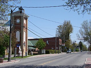
Embrun, is a community in the Canadian province of Ontario in the Eastern Ontario region. Embrun is also part of the National Capital Region. Embrun is part of the larger Russell Township in Prescott and Russell United Counties. In 2011, the urban area of Embrun had a total population of 6,380, but if surrounding agricultural areas closely tied to the community are included, the population figure rises to 8,669. This makes Embrun the largest community in the Township of Russell.
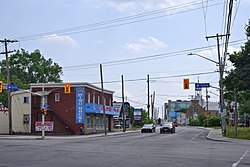
Innes Road is one of the most important corridors in the east end of the City of Ottawa, Ontario, Canada, running through the former cities of Gloucester and Cumberland. It is the main route serving Blackburn Hamlet and south Orléans, as well as several industrial and commercial areas in east Ottawa.
Alta Vista is a neighbourhood in Alta Vista Ward in Ottawa, Ontario, Canada. Its boundaries according to the Alta Vista Community Association are that part of Alta Vista Ward south of Smyth Road in the north, north of Walkley Road and east of the Rideau River, and west of the "greenspace underneath Haig Drive". However, the name is ambiguous, as there are several sub-neighbourhoods in this area,, as the neighbourhood could refer to the ward as a whole, down to the core Alta Vista area,, centred on Alta Vista Drive.

Manor Park is a neighbourhood in Rideau-Rockcliffe Ward in the east end of Ottawa, Ontario, Canada on the east side of Rockcliffe Park.

Lincoln Heights is a neighbourhood in the Britannia area of Bay Ward in the west end of Ottawa, Ontario, Canada. It is defined by its community association as being bounded to the south by the north side of Regina Lane, to the north by the Ottawa River, to the west by the east side of Croydon Avenue, and to the east by the Kichi Zibi Mikan. According to the Canada 2016 Census, the population of the neighbourhood is 1,630. The greater Lincoln Heights area can be defined as extending as far west as Greenview Avenue and as far south as Carling Avenue, which overlaps with neighbouring Britannia Village.

Orléans West-Innes Ward is a city ward in the city of Ottawa, Ontario, Canada. It is located in the eastern end of the city, containing the western half of Orleans subdivision plus the community of Blackburn Hamlet. The ward is represented on Ottawa City Council by Laura Dudas.

Civic Hospital is a neighbourhood in Kitchissippi Ward in central Ottawa, Canada. It is named after the Ottawa Civic Hospital, which is located in the neighbourhood.
Beacon Hill-Cyrville Ward is a city ward in Ottawa, Ontario. Located in the city's east end, the ward is bordered to the west by Blair Road from the Ottawa River to Ogilvie Road and St. Laurent Boulevard south of it, the south by the Via Rail train line and Innes Ward, to the east by Green's Creek and Regional Road 174 and to the north by the Ottawa River. It includes the communities of Cyrville, Rothwell Heights, Beacon Hill and Pineview.
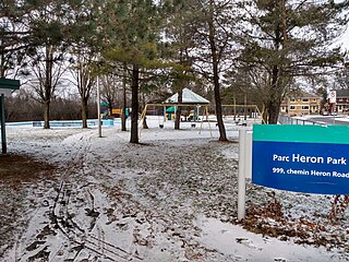
Heron Park is a neighbourhood in Capital Ward in Ottawa, Ontario, Canada. Its boundaries are the Rideau River to the north, the Sawmill Creek to the west, Bank Street to the east and Walkley Road to the south.

Carson Grove is a neighbourhood in the east end of Ottawa, Ontario, Canada. The neighbourhood spans the former Ottawa-Gloucester boundary, which still forms the boundary between Rideau-Rockcliffe Ward and Beacon Hill-Cyrville Ward.

Carleton Heights is a neighbourhood in River Ward in Ottawa, Ontario, Canada. According to the Carleton Heights and Area Community Association, the neighbourhood is bounded on the north by the Central Experimental Farm, on the east by the Rideau River, on the south by the junction of Prince of Wales Drive and Fisher Avenue and on the west by Fisher Avenue. The neighbourhood is sometimes referred to as Hog's Back after the nearby falls. The total population of the neighbourhood is 7,586 according to the Canada 2016 Census.
Ellwood is a neighbourhood and former railway point in River Ward, in the south end of Ottawa, Ontario, Canada. It is bounded by Walkley Road on the north, the Transitway on the west, Albion Road on the east, and Ledbury Park on the south. The population of this area is approximately 2908.

Foster Farm, nicknamed "the Farm", is a neighbourhood in the Britannia area of Bay Ward in the west end of Ottawa, Ontario, Canada. It is roughly bounded to the north by Richmond Road, to the east by Pinecrest Road, to the west by the former Ottawa/Nepean city limits and the south by the Highway 417, the Queensway. It is bordered by Fairfield Heights, Queensway Terrace North, Redwood, Michele Heights. The total population of this area according to the 2016 Canada Census was 3,636.

Hawthorne Meadows is a neighbourhood in Alta Vista Ward in southeast Ottawa, Ontario, Canada. It is triangular in shape; it is bounded on the west by St. Laurent Boulevard, on the northeast by Russell Road and on the south by Walkley Road. According to the Canada 2016 Census, the population of this area was 3,577.