Riverview is a neighbourhood in Ottawa, Ontario, Canada. It is southeast of the downtown adjacent to the Rideau River, its location on which is its namesake. The 2021 Census population of Riverview is 13,113.

Nepean is an area of Ottawa, Ontario, Canada. Located west of Ottawa's inner core, it was an independent city until amalgamated with the Regional Municipality of Ottawa–Carleton in 2001 to become the new city of Ottawa. However, the name Nepean continues in common usage in reference to the area. The population of Nepean is about 186,593 people.

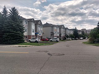
Centrepointe is a neighbourhood in College Ward in the urban west end of the city of Ottawa, Ontario, Canada. It was formerly part of the city of Nepean. It is a residential subdivision in the west/central part of Ottawa, developed from 1984 onwards, and is informally bounded by Baseline Road to the north, Woodroffe Avenue to the east, the CN railroad to the south, and the Briargreen subdivision and Forest Ridge Apartments to the west. The housing stock includes approximately 1,000 detached homes, with the remainder mostly townhomes and terrace homes.
J. S. Woodsworth Secondary School was a high school in the Borden Farm neighbourhood of Ottawa, Ontario, Canada from 1973 to 2005. Currently the school is École secondaire publique Deslauriers with the Conseil des écoles publiques de l'Est de l'Ontario.

Merivale High School is a public high school in the Borden Farm neighbourhood of Ottawa, Ontario, Canada. The school is known for its International Baccalaureate student program, but also runs French Immersion programs and visual art, music, and co-operative education programs.

Bells Corners is a suburban neighbourhood in Ottawa, Ontario, Canada. It is located along Robertson Road west of downtown, within Ottawa's western Greenbelt, in College Ward. As of the 2021 Canadian census, the community had a population of 9,385.

Rideau View is a sub-neighbourhood of Carleton Heights in River Ward, in the west-end of Ottawa, Ontario, Canada, located near the Rideau River. It is bordered by Meadowlands Drive to the south, Claymor Avenue to the west and Dynes Road to the north. Debra Avenue is the main road that runs through the neighbourhood and there is some residential housing on Eiffel Avenue. Some of parts of the neighbourhoods are east of Prince of Wales Drive and runs parallel along the Rideau River. The area is also located close to the former city of Nepean. A major feature of the neighbourhood is a low-income housing project designed and built by the Ottawa Housing corporation. There are four high-rise condominiums on Prince of Wales at the corner of Dynes and Meadowlands.

Merivale Road is an arterial road in the west end of Ottawa, Ontario, Canada. It starts at Island Park Drive just north of Highway 417 and continues south until it ends at Prince of Wales Drive in Rideau Glen. South of Clyde Avenue, Merivale is known as Ottawa Road #17, while north of Clyde it is Ottawa Road #63.

Meadowlands Drive is a suburban road in Ottawa, Ontario, Canada. It begins at Prince of Wales Drive as a continuation of Hog's Back Road in the neighborhood of Rideauview. There are two small shopping plazas and a Shell station at its corner with Prince of Wales. It then continues westward towards Fisher Avenue and consists of low-income housing projects, low-rise apartment buildings, townhouses and semi-detached homes. The speed limit here is 50 km/h (31 mph). most of Meadowlands is one lane, other than between Prince of Wales to Fisher, and from Chesterton to Merivale.
Qualicum-Graham Park or Qualicum is a suburban neighbourhood in College Ward in the City of Ottawa, Ontario, Canada. It is located in the former City of Nepean in the west end of the city. Many of the residences in the area are executive homes situated on large lots (100x100) being built in the 1960s. Qualicum Street boasts large custom houses built by Bill Teron. The neighbourhood is bounded to the north by the Queensway, to the west by Richmond Road, to the south by Baseline Road, and to the east by Morrison Drive at the former Ottawa-Nepean border towards Redwood. Named after Qualicum Beach in British Columbia.

Parkwood Hills is a neighbourhood in Knoxdale-Merivale Ward in the west end of Ottawa, Canada. Prior to amalgamation in 2001, it was located in the City of Nepean. It is notable for the thriller Parkwood Hills (2002) which was filmed on location in the area by Kolin Casagrande, and for being a typical and illustrative example of town planning and development by Minto in the context of its position as the property manager for the National Capital Commission.
Central Park is a neighbourhood in River Ward in the west end of Ottawa, Ontario, Canada. It is bounded on the east by Merivale Road, on the south by Baseline Road, on the west by Clyde Avenue and on the north by the Carlington neighbourhood. The population of the neighbourhood in 2016 was 3,888 in an area of 0.91 km2. It more than doubled its population between 2001 and 2006 as the neighbourhood expanded. Excluding the residences south of Baseline which are included in the Census Tract, the population of the neighbourhood is 3,760.

Fisher Heights is a neighbourhood located in the far northeast corner of the former City of Nepean in Ottawa, Ontario, Canada. It is located in Knoxdale-Merivale Ward. The area is located south of the Experimental Farm and approximately 8 km away from downtown Ottawa.
Trend-Arlington is a suburban neighbourhood in Knoxdale-Merivale Ward in the city of Ottawa, Ontario, Canada. The neighbourhood is located with in the former City of Nepean in the west end of the city. It is located west of Greenbank Road, east of Highway 416 and Cedarview Road, north of West Hunt Club Road and south of the Leslie Park neighbourhood. Its main road is McClellan Road, which is renamed Banner Road at its north end.
City View is a neighbourhood in College Ward in the west end of the city of Ottawa, Ontario, Canada. It is located within the former city of Nepean.
Crestview is a neighbourhood in College Ward in the west end of Ottawa, Ontario, Canada. It was originally part of the City of Nepean before amalgamation with Ottawa in 2001. Together with the neighbouring community of Meadowlands, the area is served by the Crestview-Meadowlands Community Association. The community association's boundaries are Meadowlands Drive on the north, Merivale Road on the east, the CN Railtracks on the south and Woodroffe Avenue on the west.

Foster Farm, nicknamed "the Farm", is a neighbourhood in the Britannia area of Bay Ward in the west end of Ottawa, Ontario, Canada. It is roughly bounded to the north by Richmond Road, to the east by Pinecrest Road, to the west by the former Ottawa/Nepean city limits and the south by the Highway 417, the Queensway. It is bordered by Fairfield Heights, Queensway Terrace North, Redwood, Michele Heights. The total population of this area according to the 2016 Canada Census was 3,636.
Tanglewood, also known as Tanglewood-Hillsdale, is a suburban neighbourhood in Knoxdale-Merivale Ward in the city of Ottawa, Ontario, Canada. It is located within the former City of Nepean in the west end of the city. It is located in the federal and provincial ridings of Nepean-Carleton. It is informally bounded by CN Railway to the north, Merivale Road to the east, Hunt Club Road to the south, and Woodroffe Avenue to the west.
Country Place is a residential neighbourhood near the geographical centre of Ottawa, Canada, in Knoxdale-Merivale Ward. Prior to 2001, it was part of the former city of Nepean. It is a mature residential subdivision with about 400 houses located just inside the Ottawa greenbelt near the Rideau River, and about 11 km from downtown Ottawa. It is bordered by the Black Rapids Creek and the greenbelt to the south, Prince of Wales Drive to the east, Merivale Road to the west, and the Pineglen community to the north. Amberwood Crescent meanders through the community, exiting onto Prince of Wales and Merivale. Tennyson Drive links Country Place to Pineglen.

