
Ledbury is a market town and civil parish in the county of Herefordshire, England, lying east of Hereford, and west of the Malvern Hills.

Blossom Park is a neighbourhood in Gloucester-Southgate Ward in the south-end of the city of Ottawa, Ontario, Canada. Before the 2001 city of Ottawa amalgamation it was a suburb of the city of Gloucester. The current limits of the neighbourhood are: Hunt Club Road to the north, Airport Parkway to the west, Conroy Road to the east and the Greenbelt to the south.

Bank Street is the major commercial north-south street in Ottawa, Ontario, Canada. It runs south from Wellington Street in downtown Ottawa, south through the neighbourhoods of Centretown, The Glebe, Old Ottawa South, Alta Vista, Hunt Club, and then through the villages of Blossom Park, Leitrim, South Gloucester, Greely, Metcalfe, Spring Hill, and Vernon before exiting the city limits at Belmeade Road.

Riverside Drive is a major road in Ottawa, Ontario, Canada that follows along the eastern bank of the Rideau River. Its northern terminus is at the Transitway/Via Rail underpass just south of the Queensway, and the road proceeds south to Limebank Road where it continues as River Road until the city limits. North of the Queensway, Riverside continues as Vanier Parkway, which travels through Vanier until Beechwood Avenue. The Vanier Parkway name is linked to Vanier, Ontario, which was named for former Governor General of Canada Georges Vanier.

Heron Road is a major road in Ottawa, Ontario, Canada. It runs from Walkley Road at an angle to the Rideau River, where it turns into Baseline Road. Heron is home to the Public Works and Government Services Canada headquarters, the Sir Leonard Tilley Building, the Canada Post headquarters, and the Edward Drake Building. It is also home to St. Patrick's Intermediate High School and Herongate Mall.
Conroy Road is a road in the City of Ottawa, Ontario, Canada. It runs from Walkley Road in the north to Bank Street in the south. Conroy Road forms the eastern fringe of the neighbourhood of Blossom Park, Ontario and ends in the community of Kemp Park, Ontario. Conroy Road is home to Pine Grove Forest and the Conroy Pit, owned by the National Capital Commission. Conroy Road has recently expanded, and divided between Walkley Road and Hunt Club Road due to residential expansion in Ottawa's south end. The intersection of Conroy and Walkley may be the southern terminus of the controversial Alta Vista Parkway. Conroy Road is also known as Ottawa Road #125.
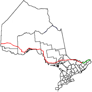
King's Highway 17, more commonly known as Highway 17, is a provincially maintained highway and the primary route of the Trans-Canada Highway through the Canadian province of Ontario. It begins at the Manitoba boundary, 50 km (31 mi) west of Kenora, and the main section ends where Highway 417 begins just west of Arnprior. A small disconnected signed section of the highway still remains within the Ottawa Region between County Road 29 and Grants Side Rd. This makes it Ontario's longest highway.
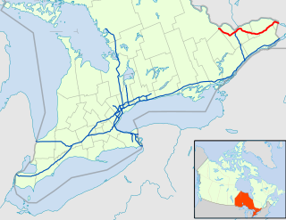
King's Highway 417, commonly referred to as Highway 417 and the Queensway through Ottawa, is a 400-series highway in the Canadian province of Ontario. It connects Ottawa with Montreal, and is the backbone of the transportation system in the National Capital Region. Within Ottawa, it forms part of the Queensway west from Highway 7 to Ottawa Regional Road 174. Highway 417 extends from the Quebec border to Arnprior, where it continues westward as Highway 17. Aside from the urban section through Ottawa, Highway 417 passes through farmland that dominates much of the fertile Ottawa Valley.

Downtown Ottawa is the central area of Ottawa, Ontario, Canada. Like other downtowns it is the commercial and economic centre of the city. It is sometimes referred to as the Central Business District and contains Ottawa's financial district. It is bordered by the Ottawa River to the north, the Rideau Canal to the east, Gloucester Street to the south and Bronson Avenue to the west. This area and the residential neighbourhood to the south are also known locally as 'Centretown'. The total population of the area is 4,876.

Alta Vista Drive is a suburban road in Ottawa, Ontario, Canada. It runs from Bank Street in the south to Industrial Avenue in the north covering the neighbourhoods of Ridgemont, Alta Vista and Riverview.
Innes Road is one of the most important streets in the east end of the City of Ottawa, Ontario, Canada, running through the former cities of Gloucester and Cumberland. It is the main route serving Blackburn Hamlet and south Orléans, as well as several industrial and commercial areas in east Ottawa. This road has changed considerably over the years.

The Sir John A. Macdonald Parkway, formerly the Ottawa River Parkway, is a four-lane scenic parkway along the Ottawa River in Ottawa, Ontario, Canada. It runs from Carling Avenue near Connaught Avenue, to Booth Street at the Canadian War Museum and National Holocaust Monument. It is maintained by the National Capital Commission. The speed limit is 60 km/h (37 mph). Bicycles are allowed on the road and on a parallel recreational path along the parkway.

Alta Vista is a neighbourhood in Alta Vista Ward in Ottawa, Ontario, Canada. Its boundaries according to the Alta Vista Community Association are that part of Alta Vista Ward south of Smyth Road in the north, north of Walkley Road and east of the Rideau River, and west of the "greenspace underneath Haig Drive". However, the name is ambiguous, as there are several sub-neighbourhoods in this area,, as the neighbourhood could refer to the ward as a whole, down to thecore Alta Vista area,, centred on Alta Vista Drive.
Albion Road is an important north–south road in the southern part of Ottawa, Ontario, Canada. The street begins in the north as Albion Road North, at Walkley Road.

Heron Park is neighbourhood in Capital Ward in Ottawa, Ontario, Canada. Its boundaries are the Rideau River to the north, the Sawmill Creek to the west, Bank Street to the east, Walkley Road to the south.

Carleton Heights is a neighbourhood in River Ward in Ottawa, Ontario, Canada. According to the Carleton Heights and Area Community Association, the neighbourhood is bounded on the north by the Central Experimental Farm, on the east by the Rideau River, on the south by the junction of Prince of Wales Drive and Fisher Avenue and on the west by Fisher Avenue. The neighbourhood is sometimes referred to as Hog's Back after the nearby falls. The total population of the neighbourhood is 7,586 according to the Canada 2016 Census.

Cyrville is a neighbourhood in Beacon Hill-Cyrville Ward in the east-end of Ottawa, Ontario, Canada. The area is located within the former City of Gloucester, and is roughly bounded on the north, west and south by the former Gloucester City limit, and on the east by the Aviation Parkway and Highway 417. Once a francophone farming village, the area now a mix of residential and industrial land, being home to the Cyrville Industrial Area. It has been described as a "tangle of freeways and utility corridors". It has a population of 4513, 280 of which live south of the Queensway.

Hawthorne Meadows is a neighbourhood in Alta Vista Ward in southeast Ottawa, Ontario, Canada. It is triangular in shape; it is bounded on the west by St. Laurent Boulevard, on the northeast by Russell Road and on the south by Walkley Road. According to the Canada 2016 Census, the population of this area was 3,577.

South Keys is a neighbourhood in Gloucester-Southgate Ward in the south end of Ottawa, Ontario, Canada. It is bounded by Johnston Road to the north, Albion Road to the east, the Airport Parkway to the west, and Hunt Club Road to the south. According to the Canada 2011 Census, the neighbourhood has a population of 2,849. The neighbourhood is part of the South Keys Greenboro Community Association.

