Lindenlea

Last updated

Lindenlea
Neighbourhood
Houses on Rockcliffe Way, Lindenlea, Ottawa.jpg
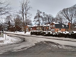
Houses on Rockcliffe Way in "Upper Lindenlea"
Newottawamap.png
Red pog.svg
Lindenlea
Location in Ottawa
Coordinates: 45°26′35″N75°40′28″W / 45.44306°N 75.67444°W / 45.44306; -75.67444
CountryCanada
Province Ontario
City Ottawa
Government
   MP Mona Fortier
   MPPs Lucille Collard
   Councillors Rawlson King
  Governing bodyLindenlea Community Association
  PresidentTanya Allem [1]
Area
  Total0.254 km2 (0.098 sq mi)
Elevation
70 m (230 ft)
Population
 (2016)
  Total1,702
  Density6,700/km2 (17,000/sq mi)
  Canada 2016 Census
Time zone UTC−5 (Eastern (EST))
  Summer (DST) UTC−4 (EDT)
Forward sortation area
K1M
Website Community Association

Lindenlea is a neighbourhood in Rideau-Rockcliffe Ward in Ottawa, Ontario, Canada, northeast of Downtown. It is bordered by Maple Lane to the north, Acacia Avenue to the east, Beechwood Avenue to the south and Springfield Road to the west. [2]

Prior to its founding in 1919, there were some homes in the area on Beechwood Avenue adjacent to the community of Clarkstown (now part of Vanier) and on Rideau Terrace. [3] It is the earliest planned community in Ottawa, dating back to the end of the First World War. The community was planned by Thomas Adams and is an example of Adams' garden suburb style. Most of the homes have large back yards, a feature of this planning style. The community is divided into upper Lindenlea, north of Rideau Terrace, and lower Lindenlea. [4] Only upper Lindenlea was planned by Adams. This part of the neighbourhood was developed by the Ottawa Housing Corporation, [5] and was bought for $66,000. [4] Lower Lindenlea was developed later but followed many of the garden suburb principles, including the large back yards, [6] and contains a "melange of 1950s brick apartments". [4] The Champlain Towers apartment complex was built by the Campeau Corporation in this section in 1962, [7] and a further development in this section called "Springfield Mews", was built in the 1980s. [4]

In 2019, to celebrate the 100th anniversary of the neighbourhood, the City of Ottawa installed commemorative street signs in the neighbourhood, replacing the regular blue and white municipal street signs. [8]

Lindenlea is notable for its picturesque architecture, mature trees, and plentiful green space. The community association produces a periodic newsletter called The Lindenleader and residents of Lindenlea also receive The New Edinburgh News produced by the community association of neighbouring New Edinburgh. Lindenlea has a children's park, tennis courts, a bowling green and a community centre. The community centre was originally a communal garage—there were so few cars that the land was purchased by three local residents for use as a car park, but was later donated to the City.

The population as of the Canada 2016 Census was 1,702. [9]

See also

Related Research Articles

<span class="mw-page-title-main">Sandy Hill, Ottawa</span> Neighbourhood in Ottawa, Ontario, Canada

Sandy Hill is a neighbourhood in Ottawa, Ontario, located just east of downtown. The neighbourhood is bordered on the west by the Rideau Canal, and on the east by the Rideau River. To the north it stretches to Rideau Street and the Byward Market area while to the south it is bordered by the Queensway highway and Nicholas Street. The area is named for its hilliness, caused by the river, and its sandy soil, which makes it difficult to erect large buildings. It is home to a number of embassies, residences and parks. Le Cordon Bleu operates its Canadian school there, at the opposite end of Sandy Hill from the University of Ottawa.

<span class="mw-page-title-main">The Glebe</span> Neighbourhood in Ottawa, Ontario, Canada

The Glebe is a neighbourhood in Ottawa, Ontario, Canada. It is located just south of Downtown Ottawa in the Capital Ward. As of 2016, the neighbourhood had a population of 13,055.

Riverview is a neighbourhood in Ottawa, Ontario, Canada. It is southeast of the downtown adjacent to the Rideau River, its location on which is its namesake. The 2021 Census population of Riverview is 13,113.

<span class="mw-page-title-main">Vanier, Ontario</span> Neighbourhood in Ottawa, Ontario, Canada

Vanier, formerly Eastview, is a neighbourhood in the Rideau-Vanier Ward of the east end of Ottawa, Ontario, Canada. Historically francophone and working class, the neighbourhood was a separate city until being amalgamated into Ottawa in 2001. It no longer has a majority francophone population. By 2012 its francophone population had shrunk to less than 40% from 63% in the early 1980s. The neighbourhood is located on the east bank of the Rideau River, across from the neighbourhoods of Lowertown and Sandy Hill, and just south of Rockcliffe Park, New Edinburgh, Lindenlea, and Manor Park. To the east of Vanier are the suburbs of Gloucester. Vanier has a relatively small area with a high population density.

<span class="mw-page-title-main">Sussex Drive</span> Ceremonial road in Ottawa

Sussex Drive, also known as Ottawa Regional Road 93, is an arterial road in Ottawa, Ontario, the capital of Canada. It is one of the city's main ceremonial and institutional routes. Travelling roughly parallel to the Ottawa River, Sussex Drive begins as a continuation of Sir George-Étienne Cartier Parkway at Rideau Gate, at the entrance to Rideau Hall. It travels south to Rideau Street, with the portion south of St. Patrick Street forming the northbound half of a one-way pair with Mackenzie Avenue. Both Mackenzie Avenue and Sussex Drive connect with Colonel By Drive at their southern end, which continues south alongside the Rideau Canal.

<span class="mw-page-title-main">New Edinburgh</span> Neighbourhood in Ottawa, Ontario, Canada

New Edinburgh is a neighbourhood in Rideau-Rockcliffe Ward, in Ottawa, Ontario, Canada. It is located to the northeast of the downtown core. It is bordered on the west by the Rideau River, to the north by the Ottawa River, to the south by Beechwood Avenue, and on the east by Springfield Road and the former Rockcliffe Park village limits.

Russell Road is an arterial road in Eastern Ontario, Canada. It begins in Ottawa in the Riverview neighbourhood and runs eastward through the rural communities of Ramsayville, Carlsbad Springs and Bearbrook in Ottawa and through the Municipality of Clarence-Rockland, connecting the communities of Cheney and Bourget, ending at Boundary Road on the eastern border of Clarence Rockland. In Ottawa it is officially Ottawa Road #26, and in Clarence-Rockland as United Counties of Prescott and Russell County Road #2.

<span class="mw-page-title-main">Lees Avenue</span>

Lees Avenue is both a road and a neighbourhood in Ottawa, Ontario, Canada. The area lies in the narrow stretch between the Rideau Canal and Rideau River south of Sandy Hill and the Queensway and is part of Old Ottawa East. The neighbourhood is dominated by five large apartment buildings, some of the largest in Ottawa. These buildings range from low cost to moderate cost and mostly house new immigrants, students and young professionals. Across the Rideau River to the east Hurdman is a more recently built such area.

<span class="mw-page-title-main">Old Ottawa East</span> Neighbourhood in Ottawa, Ontario, Canada

Old Ottawa East or just Ottawa East is a neighbourhood in Capital Ward in central Ottawa, Ontario, Canada. It is located south of Nicholas Street and between the Rideau Canal and the Rideau River, with Avenue Road marking the southern border. To the south is the neighbourhood of Old Ottawa South and to the northeast is Sandy Hill. Old Ottawa East includes the Lees Avenue area. The Flora Footbridge, which opened to pedestrians in 2019, connects the community to The Glebe.

<span class="mw-page-title-main">Alta Vista, Ottawa</span> Neighbourhood in Ottawa, Ontario, Canada

Alta Vista is a neighbourhood in Alta Vista Ward in Ottawa, Ontario, Canada. Its boundaries according to the Alta Vista Community Association are that part of Alta Vista Ward south of Smyth Road in the north, north of Walkley Road and east of the Rideau River, and west of the "greenspace underneath Haig Drive". However, the name is ambiguous, as there are several sub-neighbourhoods in this area,, as the neighbourhood could refer to the ward as a whole, down to the core Alta Vista area,, centred on Alta Vista Drive.

<span class="mw-page-title-main">Lower Town</span> Neighbourhood in Ottawa, Ontario, Canada

Lower Town (also spelled "Lowertown" is a neighbourhood in Rideau-Vanier Ward in central Ottawa, Ontario, Canada, to the east of downtown. It is the oldest part of the city. It is bounded by Rideau Street to the south, the Ottawa River to the west and north and the Rideau River to the east. It includes the commercial Byward Market area in the south-western part, and is predominantly residential in the north and east.

<span class="mw-page-title-main">Ottawa—Vanier (provincial electoral district)</span> Provincial electoral district in Ontario, Canada

<span class="mw-page-title-main">Carlington</span> Neighbourhood in Ottawa, Ontario, Canada

Carlington is a neighbourhood located in River Ward in the west-end of Ottawa, Ontario, Canada.

<span class="mw-page-title-main">Carleton Heights</span> Neighbourhood in Ottawa, Ontario, Canada

Carleton Heights is a neighbourhood in River Ward in Ottawa, Ontario, Canada. According to the Carleton Heights and Area Community Association, the neighbourhood is bounded on the north by the Central Experimental Farm, on the east by the Rideau River, on the south by the junction of Prince of Wales Drive and Fisher Avenue and on the west by Fisher Avenue. The neighbourhood is sometimes referred to as Hog's Back after the nearby falls. The total population of the neighbourhood is 7,586 according to the Canada 2016 Census.

<span class="mw-page-title-main">Centretown</span> Neighbourhood in Ottawa, Ontario, Canada

Centretown is a neighbourhood in Somerset Ward, in central Ottawa, Ontario, Canada. It is defined by the city as "the area bounded on the north by Gloucester Street and Lisgar Street, on the east by the Rideau Canal, on the south by the Queensway freeway and on the west by Bronson Avenue." Traditionally it was all of Ottawa west of the Rideau Canal, while Lower Town was everything to the east. For certain purposes, such as the census and real estate listings, the Golden Triangle and/or Downtown Ottawa is included in Centretown and it is considered part of Centretown by the Centretown Citizens Community Association as well as being used in this way in casual conversation.

<span class="mw-page-title-main">Capital Pathway</span> Bike and pedestrian pathway in Canada

<span class="mw-page-title-main">Eastway Gardens</span> Neighbourhood in Ottawa, Ontario, Canada

Eastway Gardens is a small neighbourhood in Alta Vista Ward in the east end of Ottawa, Ontario, Canada. It consists of a series of dead end streets coming off of Tremblay Road between Riverside Drive and St. Laurent Boulevard. Most of these streets are named for letters of the alphabet, beginning with Avenue K and ending with Avenue U. According to the Canada 2016 Census, the neighbourhood had a population of 602. The residents association boundaries for the neighbourhood are the Rideau River to the west, St. Laurent Boulevard to the east, Coventry Road to the north, and Belfast Road to the south.

<span class="mw-page-title-main">Belltown, Ottawa</span> Neighbourhood in Ottawa, Ontario, Canada

Belltown is a neighbourhood in the Britannia area of Bay Ward, in the west end of Ottawa. It is bounded on the east by Britannia Park, on the north by the Ottawa River, on the west by Andrew Haydon Park and the south by Carling Avenue. Prior to Ottawa's amalgamation in 2001, the neighbourhood spanned the Ottawa-Nepean municipal boundary. The neighbourhood's population is 2089, with 294 people living in the Nepean portion.

References

  1. "Board of Directors".
  2. "Vision Quest".
  3. Ottawa, Ontario. 1:63,360. Map Sheet 031G05, [ed. 4], 1918; Open Data; Producer: Survey Division, Department of Militia and Defence; Date published: 1918-01-01 (publication), 2016-01-01 (publication)
  4. 1 2 3 4 "Lindenlea: Or Best Kept Secret". Ottawa Citizen. September 29, 1984. p. D1. Retrieved February 13, 2021.
  5. "Lindenlea Garden Suburb Plotted by Town Planner". Ottawa Citizen. July 30, 1919. p. 11. Retrieved February 13, 2021.
  6. Lindenlea Community Association - History
  7. "OMB Rejects Champlain Penthouses". Ottawa Journal. September 27, 1962. p. 3. Retrieved February 13, 2021.
  8. http://ottwatch.ca/meetings/file/606134 [ bare URL PDF ]
  9. Population calculated by combining Dissemination Areas 35060213, 35061261 and 35061343 and removing Census Block 35061343006