
Kanata is a suburb and former city within Ottawa, Ontario, Canada. It is located about 22 km (14 mi) west of the city's downtown core. As of 2021, the former City of Kanata had a population of 98,938, with the population centre having a population of 137,118. Before it was amalgamated into Ottawa in 2001, it was one of the fastest-growing cities in Canada and the fastest-growing community in Eastern Ontario. Located just to the west of the National Capital Commission Greenbelt, it is one of the largest of several communities that surround central Ottawa.

Bank Street is the major commercial north–south street in Ottawa, Ontario, Canada. It runs south from Wellington Street in downtown Ottawa, south through the neighbourhoods of Centretown, The Glebe, Old Ottawa South, Alta Vista, Hunt Club, and then through the villages of Blossom Park, Leitrim, South Gloucester, Greely, Metcalfe, Spring Hill, and Vernon before ending at the city limit at Belmeade Road, becoming Stormont, Dundas and Glengarry county highway 31.

Ottawa West—Nepean is a federal electoral district in Ontario, Canada, that has been represented in the House of Commons of Canada since 1997.
King's Highway 417, commonly referred to as Highway 417 and as the Queensway through Ottawa, is a 400-series highway in the Canadian province of Ontario. It connects Ottawa with Montreal via A-40, and is the backbone of the highway system in the National Capital Region. Within Ottawa, it forms part of the Queensway west from Highway 7 to Ottawa Road 174. Highway 417 extends from the Quebec border, near Hawkesbury, to Arnprior, where it continues westward as Highway 17. Aside from the urban section through Ottawa, Highway 417 passes through farmland that dominates much of the fertile Ottawa Valley.

Carling Avenue is a major east–west arterial road in the west end of Ottawa, Ontario, Canada. It runs from March Road in Kanata to Bronson Avenue in the Glebe. The road is named for John Carling, founder of Carling Brewery and Conservative MP and Senator, Postmaster General and Minister of Agriculture.
Overbrook is an urban neighbourhood situated in Rideau-Rockcliffe Ward, in the east end of Ottawa, Ontario, Canada. It is located across the Rideau River from the neighbourhood of Sandy Hill and is just to the south of Vanier. To the east of Overbrook is the former City of Gloucester. It was constituted as a police village in 1922 and was annexed by the City of Ottawa in 1950.

Pineview is a neighbourhood in Beacon Hill-Cyrville Ward in the east end of Ottawa, Ontario, Canada. Prior to amalgamation in 2001, the neighbourhood was part of the City of Gloucester. As of the Canada 2021 Census, the neighbourhood had a population of 6,179.

Crystal Beach is a neighbourhood in Ottawa, Ontario, Canada. It is located in the west end of Ottawa, in Bay Ward. The neighbourhood is triangular in shape, and its boundaries can broadly be described as Carling Avenue to the northeast, Moodie Drive to the west, and Corkstown Road to the south. It is. According to the Canada 2011 Census, the total population of the neighbourhood was 2,416.

Carlington is a neighbourhood located in River Ward in the west-end of Ottawa, Ontario, Canada.

Orléans is a provincial electoral district in eastern Ontario, Canada. It elects one member to the Legislative Assembly of Ontario. Before the 2018 election, it was known as Ottawa—Orléans.
Qualicum-Graham Park or Qualicum is a suburban neighbourhood in College Ward in the City of Ottawa, Ontario, Canada. It is located in the former City of Nepean in the west end of the city. Many of the residences in the area are executive homes situated on large lots (100x100) being built in the 1960s. Qualicum Street boasts large custom houses built by Bill Teron. The neighbourhood is bounded to the north by the Queensway, to the west by Richmond Road, to the south by Baseline Road, and to the east by Morrison Drive at the former Ottawa-Nepean border towards Redwood. Named after Qualicum Beach in British Columbia.
Katimavik-Hazeldean is a neighbourhood in Kanata South Ward in the west end of Ottawa, Ontario, Canada. It is located in the former City of Kanata which amalgamated into Ottawa in 2001. It is located in south-central Kanata, bounded by Eagleson Road to the east, Hazeldean Road to the south, the Carp River to the west, and Highway 417 to the north.

Woodpark is a small neighbourhood in Bay Ward, in the west end of Ottawa, Ontario, Canada. It is bounded in the north by Richmond Road, to the East by Woodroffe Avenue north, in the South by Carling Avenue and in the west by the Kichi Zibi Mikan. The total population of the neighbourhood according to the Canada 2021 Census was 2,306.
Britannia Heights is a neighbourhood in Bay Ward in west end of Ottawa, Ontario, Canada. The neighbourhood is a sub-neighbourhood of Britannia area of the city, but is within the Queensway Terrace North Community Association boundaries. The neighbourhood is away from the Ottawa River on a steep hill. It is bounded to the North by Carling Avenue, east by OC Transpo Transitway, south by Henley Street, and west by Bayshore Drive. The population of the neighbourhood is approximately 1750.

Queensway Terrace North (QTN) is a neighbourhood in Bay Ward in the west end of Ottawa, Ontario, Canada. Its neighbourhood association is bounded to the north by Carling Avenue, to the west by Pinecrest Road, to the south by the Queensway, and to the east by the Transitway. These boundaries include the adjacent neighbourhood of Britannia Heights.
Redwood is a neighbourhood located in Ottawa's west end. The boundaries of the neighbourhood is Greenbank Road to the east, Baseline Road to the south, Morrison Drive to the west and Highway 417 to the north.

Foster Farm, nicknamed "the Farm", is a neighbourhood in the Britannia area of Bay Ward in the west end of Ottawa, Ontario, Canada. It is roughly bounded to the north by Richmond Road, to the east by Pinecrest Road, to the west by the former Ottawa/Nepean city limits and the south by the Highway 417, the Queensway. It is bordered by Fairfield Heights, Queensway Terrace North, Redwood, Michele Heights. The total population of this area according to the 2016 Canada Census was 3,636.
Ridgeview is a neighbourhood in College Ward in the west end of Ottawa, Ontario, Canada. It is bordered to the south by Baseline Road, to the east by Cobden Road, to the North by the Queensway, and to the west by Southwood Drive. It was developed in the 1960s along with Parkway Park.
Parkway Park is a neighbourhood in College Ward in Ottawa, Ontario, Canada. It is bounded to the north by the Queensway, to the west by Cobden Road, to the south by Baseline Road and to the east by Pinecrest Creek and the OC Transpo Transitway.

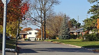
Briargreen is a suburban neighbourhood located in College Ward in the west end of Ottawa, Ontario, Canada. Prior to amalgamation in 2001 it was located in the City of Nepean. The borders of the neighbourhood are Pinecrest Cemetery to the north, Centrepointe to the east, Craig Henry to the south, and Greenbank Road to the west. The community was built in the late 1960s to early 1970s same time as the nearby neighbourhoods of Leslie Park and Arlington Woods. The main roads in the community are Ashgrove Crescent and Meadowbank Drive.

