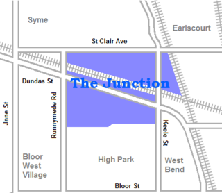
The Junction is a neighbourhood in Toronto, Ontario, Canada, that is near the West Toronto Diamond, a junction of four railway lines in the area. The neighbourhood was previously an independent city called West Toronto, that was also its own federal electoral district until amalgamating with the city of Toronto in 1909. The main intersection of the area is Dundas Street West and Keele Street. The Stockyards is the northeastern quadrant of the neighbourhood.
Westboro is an area in the west end of Ottawa, Ontario, Canada. Located along the Ottawa River, Island Park Drive defines Westboro's eastern border, while the Ottawa River defines its northern border. Under this definition, the population of the area is 22,725.

Ottawa West—Nepean is a federal electoral district in Ontario, Canada, that has been represented in the House of Commons of Canada since 1997.

Centrepointe is a neighbourhood in College Ward in the west end of the city of Ottawa, Ontario, Canada. It was formerly part of the city of Nepean. It is a newer residential subdivision in the west/central part of Ottawa, developed from 1984 onwards, and is informally bounded by Baseline Road to the north, Woodroffe Avenue to the east, the CN railroad to the south, and the Briargreen subdivision and Forest Ridge Apartments to the west. The housing stock includes approximately 1,000 detached homes, with the remainder mostly townhomes and terrace homes.

Humewood–Cedarvale is an area of Toronto, Ontario, Canada, consisting of Humewood in the south, divided by Vaughan Road and Cedarvale Ravine. The neighbourhood is bordered by Bathurst Street on the east, Eglinton Avenue to the north, Arlington Avenue to the west, and St. Clair Avenue to the south. Humewood has also been known as "the Woods" because of its many streets that have names ending with "-wood", including Wychwood, Humewood, Cherrywood, Valewood, Maplewood, Wellwood, Kenwood, and Pinewood. The neighbourhood's main commercial areas are along St. Clair Ave. W., referred to as Hillcrest Village and along Eglinton Ave. W..
Tuxedo Park is a residential neighbourhood in the northeast and northwest quadrants of Calgary, Alberta. The inner city community is bounded to the north by 32 Avenue N, by Edmonton Trail to the east, the Trans-Canada Highway to the south and 2 Street NW to the west. The community is bisected by Centre Street from north to south.
Craig Henry is a residential neighbourhood in Knoxdale-Merivale Ward in the west end of Ottawa, Canada. It is located in the former city of Nepean. It is a residential subdivision that was developed from 1971 onwards. The neighbourhood is bordered by Woodroffe Avenue to the east, Greenbank Road to the west, Knoxdale Road to the south and the CN railroad separating it from Centrepointe and Briargreen to the north. The land previously belonged to the Craig Henry farm, and was developed by Jack Aaron.
Qualicum-Graham Park or Qualicum is a suburban neighbourhood in College Ward in the City of Ottawa, Ontario, Canada. It is located in the former City of Nepean in the west end of the city. Many of the residences in the area are executive homes situated on large lots (100x100) being built in the 1960s. Qualicum Street boasts large custom houses built by Bill Teron. The neighbourhood is bounded to the north by the Queensway, to the west by Richmond Road, to the south by Baseline Road, and to the east by Morrison Drive at the former Ottawa-Nepean border towards Redwood. Named after Qualicum Beach in British Columbia.
Glen Cairn is a neighbourhood in Kanata South Ward in the west end of Ottawa, Ontario, Canada. It is also the name of a public school in the area. Prior to amalgamation in 2001, it was located in the City of Kanata. It is located in South Kanata, about 22 km (14 mi) west of Downtown Ottawa. It was one of the original neighbourhoods in Kanata. The community was built in the 1960s, and was part of Goulbourn Township until the creation of Kanata in 1978. As of the Canada 2016 Census, there were 11,836 people living in Glen Cairn.
Katimavik-Hazeldean is a neighbourhood in Kanata South Ward in the west end of Ottawa, Ontario, Canada. It is located in the former City of Kanata which amalgamated into Ottawa in 2001. It is located in south-central Kanata, bounded by Eagleson Road to the east, Hazeldean Road to the south, the Carp River to the west, and Highway 417 to the north.
Leslie Park is a suburban neighbourhood in College Ward in the city of Ottawa, Ontario, Canada. It is located in the former city of Nepean.
Trend-Arlington is a suburban neighbourhood in Knoxdale-Merivale Ward in the city of Ottawa, Ontario, Canada. The neighbourhood is located with in the former City of Nepean in the west end of the city. It is located west of Greenbank Road, east of Highway 416 and Cedarview Road, north of West Hunt Club Road and south of the Leslie Park neighbourhood. Its main road is McClellan Road, which is renamed Banner Road at its north end.
City View is a neighbourhood in College Ward in the west end of the city of Ottawa, Ontario, Canada. It is located within the former city of Nepean.
Copeland Park is a neighbourhood located in College Ward in the west end of Ottawa, Canada. It is bounded to the west by Agincourt Road, to the south by Baseline Road, to the east by Clyde Avenue and to the north by the Central Experimental Farm Pathway.
Manordale is a neighbourhood in Knoxdale-Merivale Ward in the west end of Ottawa, Ontario, Canada. It is located in the former City of Nepean. It is bounded on the north and west by Knoxdale Road, east by Woodroffe Avenue, and south by Hunt Club Road.

Foster Farm, nicknamed "the Farm", is a neighbourhood in the Britannia area of Bay Ward in the west end of Ottawa, Ontario, Canada. It is roughly bounded to the north by Richmond Road, to the east by Pinecrest Road, to the west by the former Ottawa/Nepean city limits and the south by the Highway 417, the Queensway. It is bordered by Fairfield Heights, Queensway Terrace North, Redwood, Michele Heights. The total population of this area according to the 2016 Canada Census was 3,636.

Queensway Terrace South is a neighbourhood in College Ward in the west end of Ottawa, Ontario, Canada. It used to be part of Queensway Terrace but in 1967, Highway 417 was built and split apart into Queensway Terrace North and South. The borders are to the east Southwood Drive, to the south Baseline Road, Queensway to the north and Greenbank Road to the west. Along with next-door Ridgeview, the neighbourhood is part of the Queensway Terrace South Ridgeview Community Association.
Ridgeview is a neighbourhood in College Ward in the west end of Ottawa, Ontario, Canada. It is bordered to the south by Baseline Road, to the east by Cobden Road, to the North by the Queensway, and to the west by Southwood Drive. It was developed in the 1960s along with Parkway Park.
Parkway Park is a neighbourhood in College Ward in Ottawa, Ontario, Canada. It is bounded to the north by the Queensway, to the west by Cobden Road, to the south by Baseline Road and to the east by Pinecrest Creek and the OC Transpo Transitway.
Country Place is a residential neighbourhood near the geographical centre of Ottawa, Canada, in Knoxdale-Merivale Ward. Prior to 2001, it was part of the former city of Nepean. It is a mature residential subdivision with about 400 houses located just inside the Ottawa greenbelt near the Rideau River, and about 11 km from downtown Ottawa. It is bordered by the Black Rapids Creek and the greenbelt to the south, Prince of Wales Drive to the east, Merivale Road to the west, and the Pineglen community to the north. Amberwood Crescent meanders through the community, exiting onto Prince of Wales and Merivale. Tennyson Drive links Country Place to Pineglen.
