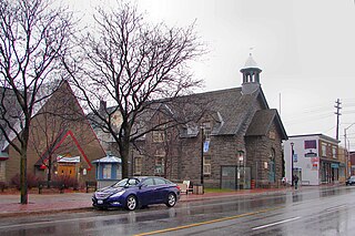
Westboro is an area in the west end of Ottawa, Ontario, Canada. Located along the Ottawa River, Island Park Drive defines Westboro's eastern border, while the Ottawa River defines its northern border. Under this definition, the population of the area is 22,725.

Downsview is a neighbourhood in the north end of Toronto, Ontario, Canada, located in the district of North York. The area takes its name from the Downs View farm established around 1842 near the present-day intersection of Keele Street and Wilson Avenue. It now extends beyond the intersection of Sheppard Avenue and Dufferin Street, though it is popularly seen as including the areas to the north right up to the Toronto city limit at Steeles Avenue. The area includes several large post-World War II subdivisions. Within the area is Downsview Airport, the former site of Canadian Forces Base Downsview, which has since been largely converted following the end of the Cold War into an urban park known as Downsview Park. The airport is still used as a manufacturing and testing facility for Bombardier Aerospace.

Lawrence Heights is a neighbourhood in Toronto, Ontario, Canada. It is located north-west of central Toronto, in the district of North York. The neighbourhood is roughly bounded by Lawrence Avenue to the south, Yorkdale Road to the north, Varna Drive to the east and Dufferin Street to the west. It is part of the greater Yorkdale-Glen Park official Toronto neighbourhood.

Barrhaven is a suburb of Ottawa, Ontario, Canada. It is located about 17 km (11 mi) southwest of the city's downtown core. Prior to amalgamation with Ottawa in 2001, Barrhaven was part of the City of Nepean. Its population as of the Canada 2021 Census was 103,234.

Humber Summit is a neighbourhood in Toronto, Ontario, Canada. It is one of the northernmost neighbourhoods in Toronto, located in the North York district of the city. It is bounded by Steeles Avenue to the north, Highway 400 to the east, Finch Avenue to the south, and follows the Humber River to the west.
For the settlement established by former slaves in Guyana known as Victoria Village see Victoria, Guyana

Crystal Beach is a neighbourhood in Ottawa, Ontario, Canada. It is located in the west end of Ottawa, in Bay Ward. The neighbourhood is triangular in shape, and its boundaries can broadly be described as Carling Avenue to the northeast, Moodie Drive to the west, and Corkstown Road to the south. It is. According to the Canada 2011 Census, the total population of the neighbourhood was 2,416.

Yunnan is a sub located in the town of Jurong West in the West Region of Singapore.
Qualicum-Graham Park or Qualicum is a suburban neighbourhood in College Ward in the City of Ottawa, Ontario, Canada. It is located in the former City of Nepean in the west end of the city. Many of the residences in the area are executive homes situated on large lots (100x100) being built in the 1960s. Qualicum Street boasts large custom houses built by Bill Teron. The neighbourhood is bounded to the north by the Queensway, to the west by Richmond Road, to the south by Baseline Road, and to the east by Morrison Drive at the former Ottawa-Nepean border towards Redwood. Named after Qualicum Beach in British Columbia.
Katimavik-Hazeldean is a neighbourhood in Kanata South Ward in the west end of Ottawa, Ontario, Canada. It is located in the former City of Kanata which amalgamated into Ottawa in 2001. It is located in south-central Kanata, bounded by Eagleson Road to the east, Hazeldean Road to the south, the Carp River to the west, and Highway 417 to the north.
Leslie Park is a suburban neighbourhood in College Ward in the city of Ottawa, Ontario, Canada. It is located in the former city of Nepean.
Trend-Arlington is a suburban neighbourhood in Knoxdale-Merivale Ward in the city of Ottawa, Ontario, Canada. The neighbourhood is located with in the former City of Nepean in the west end of the city. It is located west of Greenbank Road, east of Highway 416 and Cedarview Road, north of West Hunt Club Road and south of the Leslie Park neighbourhood. Its main road is McClellan Road, which is renamed Banner Road at its north end.
Wellington Village is a neighbourhood in Kitchissippi Ward in the west end of Ottawa, Ontario, Canada. It is bounded on the north by Scott Street, on the west by Island Park Drive, on the south by The Queensway and on the east by Holland Avenue. The neighbourhood is covered by the Wellington Village Community Association, with the exception of Island Park Drive, which is covered by the Island Park Community Association. The neighbourhood was originally named Elmdale for the number of elm trees in the area, and was founded in 1922. The homes were built between the 1920s and 1940s.

Riverside Park is a neighbourhood in the south end of Ottawa, Canada.
City View is a neighbourhood in College Ward in the west end of the city of Ottawa, Ontario, Canada. It is located within the former city of Nepean.
Arbeatha Park is a sub-neighbourhood of Lynwood Village, which is in turn a sub-neighbourhood of Bells Corners in the west end of Ottawa, Ontario, Canada. Bounded to the west is Moodie Drive, north is Old Richmond Road, east is Lynwood Village and south is a forest owned by the city of Ottawa.

Queensway Terrace South is a neighbourhood in College Ward in the west end of Ottawa, Ontario, Canada. It used to be part of Queensway Terrace but in 1967, Highway 417 was built and split apart into Queensway Terrace North and South. The borders are to the east Southwood Drive, to the south Baseline Road, Queensway to the north and Greenbank Road to the west. Along with next-door Ridgeview, the neighbourhood is part of the Queensway Terrace South Ridgeview Community Association.
Parkway Park is a neighbourhood in College Ward in Ottawa, Ontario, Canada. It is bounded to the north by the Queensway, to the west by Cobden Road, to the south by Baseline Road and to the east by Pinecrest Creek and the OC Transpo Transitway.

Briargreen is a suburban neighbourhood located in College Ward in the west end of Ottawa, Ontario, Canada. Prior to amalgamation in 2001 it was located in the City of Nepean. The borders of the neighbourhood are Pinecrest Cemetery to the north, Centrepointe to the east, Craig Henry to the south, and Greenbank Road to the west. The community was built in the late 1960s to early 1970s same time as the nearby neighbourhoods of Leslie Park and Arlington Woods. The main roads in the community are Ashgrove Crescent and Meadowbank Drive.
