Gloucester is a suburb of and within the City of Ottawa. Gloucester Township was established in 1792 and originally included lands east of the Rideau River from the Ottawa River south to Manotick. It was incorporated as a township in 1850 and became a city in 1981. Gloucester was one of the 11 municipalities that merged in 2001 to form the new city of Ottawa. As of the Canada 2016 Census, the former city of Gloucester had a population of 133,280.

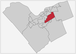
Orléans is a federal electoral district in Ottawa, Ontario, Canada, that has been represented in the House of Commons of Canada since 1988.
Chapel Hill is a neighbourhood in the east end Ottawa, Ontario, Canada within the community of Orleans. It is considered an outer-suburb of Ottawa, and before the 2001 amalgamation of the city of Ottawa, it was part of the former City of Gloucester. Chapel Hill consists of mostly single family homes situated next to the National Capital Commission (NCC) Greenbelt and surrounding rural areas. The area is divided into two parts by Innes Road: Chapel Hill North and Chapel Hill South.
The Regional Municipality of Ottawa–Carleton was a regional government area and census division in Ontario, Canada, which existed from 1969 until 2001. It was created in 1969 from the former Carleton County plus Cumberland Township, previously part of Russell County.

Orleans, is a suburb of Ottawa, Ontario, Canada. It is located in the eastern part of the city along the Ottawa River, about 16 km (10 mi) from downtown Ottawa. The Canada 2011 Census determined that Orleans' population was 107,823. Prior to being amalgamated into Ottawa in 2001, the community of Orleans was spread over two municipal jurisdictions, the eastern portion being in the pre-amalgamation City of Cumberland, the western portion in the City of Gloucester. According to the 2016 census, 69,178 people lived in the Cumberland portion of Orleans, while 47,510 people lived in the Gloucester portion. Today, Orleans spans the municipal wards of Orléans, Innes and Cumberland. Orleans contains a significant francophone minority, although this has been declining in recent decades.
Ficko is a dispersed rural community in Osgoode Ward in Ottawa, Ontario, Canada. It is located in the former City of Gloucester, which was amalgamated into Ottawa in 2001. The community is located on Bowesville Road halfway between Armstrong Road and Rideau Road.
Gloucester Glen is a community on the Rideau River in eastern Ontario, Canada. It is located in the former City of Gloucester in the City of Ottawa. It is between the communities of Cedardale to the north and Honey Gables to the south, and bound by the Rideau River to the west and River Road to the east, adjacent to the new Riverside South subdivision. It is a very quiet community with many older homes. There are approximately only 45 houses that make up this community.

Osgoode is a population centre in Osgoode Ward in the rural south end of Ottawa, Ontario, Canada. It is located just 2 km east of the Rideau River. Until amalgamation in 2001, it was located in Osgoode Township. According to the Canada 2011 Census Osgoode had a population of 2,453.

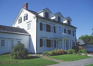
The Billings Estate National Historic Site is a heritage museum in Ottawa, Ontario, Canada. It is located at 2100 Cabot St. in the former home of one of the region's earliest settlers. The oldest wood-framed house in Ottawa was built in 1827-9 by Massachusetts-born Braddish Billings. It became the home for the following four generations of the Billings family. It is Ottawa's oldest surviving house, though the Bytown Museum building is older. Billings had moved to the area in 1812, and was the first settler in Gloucester Township.
Leitrim is a dispersed rural community in the South Gloucester section of Ottawa, Ontario, Canada, and is named for the Irish County Leitrim. The area comprises the rapidly growing Findlay Creek suburban neighbourhood.
Pineview is a neighbourhood in Beacon Hill-Cyrville Ward in the east end of Ottawa, Ontario, Canada. Prior to amalgamation in 2001, the neighbourhood was part of the City of Gloucester. As of the Canada 2011 Census, the neighbourhood had a population of 6,163
Hunt Club is a community in River Ward, in the south end of Ottawa, Ontario, Canada. The area is named after the prestigious Ottawa Hunt and Golf Club, which has been part of the area since 1876. Hunt Club Road and many local businesses were also named after the golf course.

Orléans is a provincial electoral district in eastern Ontario, Canada. It elects one member to the Legislative Assembly of Ontario. Before the 2018 election, it was known as Ottawa—Orléans.

Findlay Creek is a suburban neighbourhood in Gloucester-South Nepean Ward in the south end of Ottawa, Ontario, Canada. It is located just south-west of the intersection of Leitrim Road and Bank Street. The eponymous Findlay Creek springs in the Leitrim Wetlands, directly south of the neighbourhood, and is a tributary of the North Castor River.
McKellar Park is a neighbourhood located in Kitchissippi Ward in the west end of Ottawa, Ontario, Canada. It is sometimes considered to be part of the greater Westboro area. It is bounded on the east by Denbury Avenue, on the south and west by Sherbourne Avenue and on the north by the Ottawa River. It is considered a trendy and expensive area, being close to the Westboro Village.

Ramsayville is a rural community on Ramsay Creek in Gloucester-Southgate Ward in Ottawa, Ontario, Canada. Prior to 2001, the community was located within the City of Gloucester.
Carson Grove is a neighbourhood in the east end of Ottawa, Ontario, Canada. The neighbourhood spans the former Ottawa-Gloucester boundary, which still forms the boundary between Rideau-Rockcliffe Ward and Beacon Hill-Cyrville Ward.

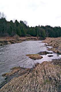
Green's Creek45°28′00″N75°34′35″W is a small tributary of the Ottawa River that flows through the community of Gloucester in eastern Ottawa. It has cut deeply into sediments of the Champlain sea, producing a complex mixture of forest types, from upland oak and pine to floodplain forest. As a consequence there are nearly 500 species of plants known from the area. There is a large area of silver maple swamp where it enters the Ottawa River; this is one of the most important wetland complexes along the south shore of the Ottawa River. Rare species include the only population of the provincially rare pinedrops in the region, and the only regional population of witch-hazel. The area is conserved as part of the Ottawa Greenbelt and 5.5 kilometres of walking trails have been maintained as part of the Green's Creek Valley conservation area.
McKellar Heights is a small neighbourhood located in Kitchissippi Ward, in the west end of Ottawa, Ontario, Canada. It is bounded on the north by Carling Avenue, on the west by Maitland Avenue, on the south by The Queensway and on the east by Clyde Avenue. The population as of the 2011 Census was 557.
Cyrville is a neighbourhood in Beacon Hill-Cyrville Ward in the east-end of Ottawa, Ontario, Canada. The area is located within the former City of Gloucester, and is bounded on the north, west and south by the former Gloucester City limit, and on the east by the Aviation Parkway and Highway 417. The area is mostly Industrial in nature. It has a population of 4611, 342 of which live south of the Queensway.


