
The Alfred River is a river in New Zealand's Tasman region. It runs west-southwest from its source in the Spenser Mountains to its junction with the Maruia River. The schist in the river contains hornblende. The area has a temperate oceanic climate. Gold is said to have been found in the area.
Forest & Bird, also known by its formal name as the Royal Forest and Bird Protection Society of New Zealand, is an environmental organisation specialising in the protection and conservation of New Zealand's indigenous flora and fauna and unique wild places and natural ecosystems. Forest & Bird consists of 47 branches located in urban and rural centres throughout New Zealand. Branches are actively engaged in conservation projects and advocacy on a community, regional and national basis. Forest & Bird has offices and staff located in Auckland, Christchurch, Wellington, Nelson and Dunedin. Forest & Bird publishes a quarterly magazine Forest & Bird, one of New Zealand's definitive natural history and conservation publications.

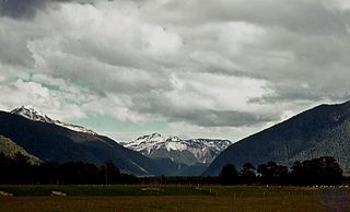
Lewis Pass is the northernmost of the three main mountain passes through the Southern Alps in the South Island of New Zealand. With an elevation of 907 metres, it is slightly lower than Arthur's Pass and higher than Haast Pass.
Native Forest Action Council was an environmental organisation in New Zealand.
The Ecologic Foundation is an environmental organisation in New Zealand.
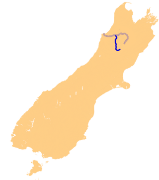
The Maruia River is located in the northwestern South Island of New Zealand. It is a major tributary of the Buller River, flowing for 80 km before joining the larger river eight kilometres to the west of Murchison.
New Zealand has a large number of hot springs. Many of them are used for therapeutic purposes.
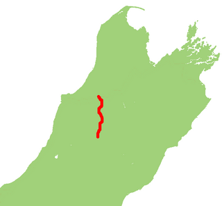
State Highway 65 is a New Zealand state highway in the South Island. It is 71 km long and runs south to north down the Maruia river valley from SH 7 at Springs Junction, 15 km west of the main divide at the Lewis Pass, to SH 6 in the Buller Gorge, 11 km west of Murchison. It forms part of the most direct route between Christchurch and Nelson. It takes its name from a small settlement toward its northern end.

State Highway 7 is a major New Zealand state highway. One of the eight national highways, it crosses the Southern Alps to link the West Coast Region with Canterbury and to form a link between the South Island's two longest highways, State Highway 1 and State Highway 6. Distances are measured from east to west with the major junction list going from east to west.
Maruia is a locality in the West Coast region of New Zealand. The Shenandoah Highway passes through it. Murchison is 65 km north, the Lewis Pass is 39 km to the south-east, and Reefton is 63 km west by road. The Maruia River flows past to the west.
Grey Valley is a former parliamentary electorate in the West Coast region of New Zealand. The electorate was created for the 1871 general election as a single-member electorate, became a two-member electorate for the 1876 general election, and was split between the single-member electorates of Greymouth and Inangahua for the 1881 general election.
The Blue Grey River is a river in New Zealand. It is an upper tributary of the Grey River, flowing from Lake Christabel, close to the township of Maruia Springs, and flowing west for 8 kilometres (5 mi) before reaching the upper Grey River.
The Rahu River is a river in the Buller District of New Zealand's South Island. It rises in two branches within Victoria Forest Park. From the junction of these two branches, the Rahu flows initially southeast before turning north to flow into the Maruia River 5 kilometres (3.1 mi) north of Springs Junction. State Highway 7 follows the upper course of the Rahu to the northwest of Springs Junction, crossing the Rahu Saddle into the valley of the Inangahua River.
The Rappahannock River is a river of the Tasman Region of New Zealand's South Island. It flows predominantly north from its sources east of Maruia, reaching the Warwick River five kilometres from the latter's outflow into the Maruia River.
The Shenandoah River is a river in New Zealand's West Coast Region. It flows northwest to reach the Maruia River 25 kilometres southeast of Inangahua.
The Warwick River is a river of the Tasman Region of New Zealand's South Island. It flows southwest to reach the Maruia River 10 kilometres north of Maruia. State Highway 65 follows the course of the Warwick River for some of its length.

Water is relatively abundant in New Zealand due to the temperate climate and maritime weather patterns. In recent years, water pollution and draw-down of aquifers have become important environmental issues in New Zealand.
Lawrence John Woolley, known as John Woolley, is a sport shooter from New Zealand who has represented New Zealand at three Olympic Games and four Commonwealth Games.
Henry Lewis was a New Zealand surveyor.

Maruia Springs is a settlement in the West Coast Region of New Zealand's South Island. It is located on the south bank of the Maruia River on State Highway 7 to the west of the Lewis Pass.
