Related Research Articles

Seagrasses are the only flowering plants which grow in marine environments. There are about 60 species of fully marine seagrasses which belong to four families, all in the order Alismatales. Seagrasses evolved from terrestrial plants which recolonised the ocean 70 to 100 million years ago.

A reef is a ridge or shoal of rock, coral or similar relatively stable material, lying beneath the surface of a natural body of water. Many reefs result from natural, abiotic (non-living) processes such as deposition of sand or wave erosion planing down rock outcrops. However, reefs such as the coral reefs of tropical waters are formed by biotic (living) processes, dominated by corals and coralline algae. Artificial reefs such as shipwrecks and other man-made underwater structures may occur intentionally or as the result of an accident, and are sometimes designed to increase the physical complexity of featureless sand bottoms to attract a more diverse range of organisms. Reefs are often quite near to the surface, but not all definitions require this.

Shark Bay is a World Heritage Site in the Gascoyne region of Western Australia. The 23,000-square-kilometre (8,900 sq mi) area is located approximately 800 kilometres (500 mi) north of Perth, on the westernmost point of the Australian continent. UNESCO's official listing of Shark Bay as a World Heritage Site reads:

The Shark Bay Marine Park is protected marine park located within the UNESCO World Heritage–listed Shark Bay, in the Gascoyne region of Western Australia. The 748,725-hectare (1,850,140-acre) marine park is situated over 800 km (500 mi) north of Perth and 400 kilometres (250 mi) north of Geraldton.

The Carnarvon xeric shrublands is a deserts and xeric shrublands ecoregion of Western Australia. The ecoregion is coterminous with the Carnarvon Interim Biogeographic Regionalisation for Australia (IBRA) bioregion.

Coral Bay is a small coastal settlement located 1,200 kilometres (750 mi) north of Perth, in the Shire of Carnarvon in the Gascoyne region of Western Australia.

The Ningaloo Coast is a World Heritage Site located in the north west coastal region of Western Australia. The 705,015-hectare (1,742,130-acre) heritage-listed area is located approximately 1,200 kilometres (750 mi) north of Perth, along the East Indian Ocean. The distinctive Ningaloo Reef that fringes the Ningaloo Coast is 260 kilometres (160 mi) long and is Australia's largest fringing coral reef and the only large reef positioned very close to a landmass. The Muiron Islands and Cape Farquhar are within this coastal zone.

A seagrass meadow or seagrass bed is an underwater ecosystem formed by seagrasses. Seagrasses are marine (saltwater) plants found in shallow coastal waters and in the brackish waters of estuaries. Seagrasses are flowering plants with stems and long green, grass-like leaves. They produce seeds and pollen and have roots and rhizomes which anchor them in seafloor sand.
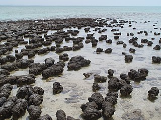
The Hamelin Pool Marine Nature Reserve is a protected marine nature reserve located in the UNESCO World Heritage–listed Shark Bay in the Gascoyne region of Western Australia. The 127,000-hectare (310,000-acre) nature reserve boasts the most diverse and abundant examples of living marine stromatolites in the world, monuments to life on Earth over 3,500 million years BP.
The Shoalwater Bay Military Training Area is a heritage-listed military installation at Byfield Road, Byfield, Shire of Livingstone, Queensland, Australia. It is a large, relatively undisturbed and intact natural system with a wide variety of coastal landforms and a high level of biodiversity. It contains a diverse range of marine and coastal wetland landscapes, vegetation types and ecosystems. It was added to the Australian Commonwealth Heritage List on 22 June 2004.

Faure Island is a 58 km2 island pastoral lease and nature reserve, east of the Francois Peron National Park on the Peron Peninsula, in Shark Bay, Western Australia. It lies in line with the Monkey Mia resort to the west, and the Wooramel River on the eastern shore of Shark Bay. It is surrounded by the Shark Bay Marine Park and Shark Bay World Heritage Site and, as the Faure Island Sanctuary, is owned and managed by the Australian Wildlife Conservancy (AWC).
The Central Western Shelf Province, also known as the Shark Bay marine ecoregion, is a biogeographic region of Australia's continental shelf and coastal waters. It includes the subtropical coastal waters of Western Australia.

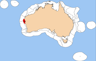
Posidonia australis, also known as fibre-ball weed or ribbon weed, is a species of seagrass that occurs in the southern waters of Australia. It forms large meadows important to environmental conservation. Balls of decomposing detritus from the foliage are found along nearby shore-lines.
The Seagrasses of Western Australia are submerged flowering plants found along the coast, around islands, and in Estuaries of Western Australia. The region contains some of the largest seagrass meadows in the world, and is the most diverse in the number of species. The variety of habitats along its western and southern coasts is often soft sands in shallow subtropical waters, ideal for these plants.

A marine habitat is a habitat that supports marine life. Marine life depends in some way on the saltwater that is in the sea. A habitat is an ecological or environmental area inhabited by one or more living species. The marine environment supports many kinds of these habitats.
Cymodocea nodosa is a species of seagrass in the family Cymodoceaceae and is sometimes known as little Neptune grass. As a seagrass, it is restricted to growing underwater and is found in shallow parts of the Mediterranean Sea and certain adjoining areas of the Atlantic Ocean.

Wooramel Station is a pastoral lease and sheep station located 78 kilometres (48 mi) east of Denham and 113 kilometres (70 mi) south east of Carnarvon in the Gascoyne region of Western Australia.
The Wooramel River is an ephemeral river in the Gascoyne region of Western Australia.

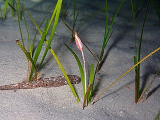
Zostera muelleri is a southern hemisphere temperate species of seagrass native to the seacoasts of South Australia, Victoria and Tasmania. and New Zealand. Today, Zostera muelleri can be found in regions of Australia, New Zealand, and Papua New Guinea, as well as areas of the eastern Indian Ocean, and the southwest and western central Pacific Ocean. Zostera muelleri is a marine angiosperm, and is commonly referred to as eelgrass or garweed. It is a fast growing and readily colonizing species that serves as a feeding ground for wading birds and aquatic animals, and a breeding ground for juvenile fish and shrimp species.

Lindsay Boyd Collins was an Australian marine geologist and sedimentologist, and a faculty member in the Department of Applied Geology at Curtin University in Western Australia. He was interested in studying the continental shelf of Western Australia and coral reefs. Collins was a prominent scholar, and completed projects on continental shelf mapping of Australian shelves, microbialites and seagrass banks at Shark Bay, and coral reef studies at the Abrolhos, Ningaloo, Scott Reef, the Rowley Shoals and the Kimberley.
References
- ↑ Bird, S. A; University of Western Australia. Dept. of Geology. Thesis (1986), Origin and emplacement of fine sediment, Wooramel Seagrass Bank, Shark Bay, Western Australia , retrieved 30 December 2013
- ↑ Considine, Mary-Lou (2013), "Is Shark Bay shifting from temperate to tropical?", ECOS, CSIRO PUBLISHING, 2013 (182), retrieved 30 December 2013
- ↑ Davies, G.R. 1970 A Recent Seagrass Bank, Shark Bay, Western Australia. In Logan et al. 'Carbonate Sedimentation And Environments, Shark Bay, W.A.' American Association of Petroleum Geol 'Memoir 13: 85-168.
- ↑ "Wooramel Seagrass Bank, Carnarvon, WA, Australia (Place ID 10785)". Australian Heritage Database . Australian Government.