
Victoria Island is a large island in the Canadian Arctic Archipelago that straddles the boundary between Nunavut and the Northwest Territories of Canada. It is the eighth largest island in the world, and at 217,291 km2 (83,897 sq mi) in area, it is Canada's second largest island. It is nearly double the size of Newfoundland (111,390 km2 [43,008 sq mi]), and is slightly larger than the island of Great Britain (209,331 km2 [80,823 sq mi]) but smaller than Honshu (225,800 km2 [87,182 sq mi]). It contains the world's largest island within an island within an island. The western third of the island belongs to the Inuvik Region in the Northwest Territories; the remainder is part of Nunavut's Kitikmeot Region.

Bridgeman Island or Bridgemans's Island or Bridgman Island or Helena Island is one of the South Shetland Islands. It is an almost circular, volcanic island marked by steep sides, 0.8 kilometres (0.5 mi) long and 240 m (787 ft) high, lying 37 kilometres (23 mi) east of King George Island. Bridgeman Island is located at 62°04′S56°44′W and has an elevation of 240 m (787 ft). Bridgeman Island is an established name dating back to about 1820. Bridgeman Island is the remnants of a much larger volcanic edifice that is now largely submerged. The eroded volcano does not display youthful volcanic features. Several reports of 19th-century fumarolic activity may instead refer to the much younger Penguin Island.
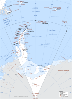
Argentine Antarctica is a sector of Antarctica claimed by Argentina as part of its national territory consisting of the Antarctic Peninsula and a triangular section extending to the South Pole, delimited by the 25° West and 74° West meridians and the 60° South parallel. This region overlaps with British and Chilean claims in Antarctica; however, all claims are suspended by the Antarctic Treaty System, of which Argentina is a founding signatory and permanent consulting member, with the Antarctic Treaty Secretariat being based in Buenos Aires.

Galindez Island is an island 0.8 kilometres (0.5 mi) long, lying immediately east of Winter Island in the Argentine Islands, Wilhelm Archipelago. It was discovered by the French Antarctic Expedition, 1903–05, under Jean-Baptiste Charcot, who named it for Commander Ismael Galindez of the Argentine Navy, who was dispatched in the Uruguay to search for Charcot, when the expedition was feared lost early in 1905. The island was recharted by the British Graham Land Expedition (BGLE) under John Riddoch Rymill, 1934–37.

Sir James Mann Wordie CBE FRSE LLD was a Scottish polar explorer and geologist.
Telefon Rocks is a group of rocks 1.5 miles (2.4 km) south-southwest of Demay Point, and just east of Telefon Point, at the west side of the entrance to Admiralty Bay, King George Island, in the South Shetland Islands. Named after the Telefon, a vessel which went aground and was abandoned there in 1908.

Charity Glacier is a glacier on Rozhen Peninsula, Livingston Island in the South Shetland Islands, Antarctica draining the southwest slopes of St. Methodius Peak in Tangra Mountains, and flowing west-southwestwards into False Bay north of Barnard Point, between Zagore Beach and Arkutino Beach.

The Argentine Islands are a group of islands in the Wilhelm Archipelago of Antarctica, situated 5 nautical miles (9 km) southwest of Petermann Island, and 4 nautical miles (7 km) northwest of Cape Tuxen on Kiev Peninsula in Graham Land. They were discovered by the French Antarctic Expedition, 1903–05, under Jean-Baptiste Charcot, and named by him for the Argentine Republic in appreciation of that government's support of to his expedition.
Winship Point is a point at the west side of the entrance to Potter Cove, King George Island, in the South Shetland Islands. Named by the United Kingdom Antarctic Place-Names Committee (UK-APC) in 1960 for Jonathan Winship, master of the ship O'Cain in 1820-21, operating from Potter Cove.

The borders of the oceans are the limits of the Earth's oceanic waters. The definition and number of oceans can vary depending on the adopted criteria.
Bertodano Bay is a bay between Bodman Point and Cape Wiman on the north side of Seymour Island. The name appears on Argentine navy charts from 1957 and recalls J. Lopez de Bertodano, chief engineer in the Argentine corvette Uruguay during the rescue of the shipwrecked Swedish Antarctic Expedition in 1903.
Neptune Glacier is a glacier on the east coast of Alexander Island, Antarctica, 12 nautical miles (22 km) long and 4 nautical miles (7 km) wide, flowing east into George VI Sound and the George VI Ice Shelf to the south of Triton Point. Although Neptune Glacier is not located within the mountain range Planet Heights, the glaciers name derives from the mountain range along with many other nearby glaciers named after planets of the Solar System. There are also other nearby landforms named in association with these glaciers. The glacier was first sighted from the air by Lincoln Ellsworth on November 23, 1935, and roughly mapped from photos obtained on that flight by W.L.G. Joerg. The mouth of the glacier was positioned in 1936 by the British Graham Land Expedition (BGLE). Named by the United Kingdom Antarctic Place-Names Committee (UK-APC) for the planet Neptune following a Falkland Islands Dependencies Survey (FIDS) survey in 1949. The head of the glacier was mapped from air photos taken by the Ronne Antarctic Research Expedition (RARE), 1947–48, by Searle of the FIDS in 1960.
Sulphur Point is a prominent bluff 1.5 nautical miles (2.8 km) north of Wordie Point on the west side of Visokoi Island in the South Sandwich Islands. It was named West Bluff because of its position by DI personnel following their survey in 1930, but the name has been changed to avoid duplication with West Bluff on nearby Zavodovski Island. Sulphur Point was recommended in 1953 by the United Kingdom Antarctic Place-Names Committee (UK-APC). The ground here is reddish in color with patches and streaks of sulphur, and strong sulphurous fumes have been noted by all visitors to this island.

Stinker Point is a headland 7 km (4.3 mi) south of Table Bay on the west coast of Elephant Island, in the South Shetland Islands of Antarctica. It was mapped by the UK Joint Services Expedition to Elephant Island, 1970–71, and named after the southern giant petrels which breed there, "stinker" being an old sailors' name for the bird.
Eureka Glacier is a broad, gently sloping glacier, 18 nautical miles (33 km) long and 17 nautical miles (31 km) wide at its mouth, which flows westward from the west side of Palmer Land into George VI Sound. It is bounded on its north side by the nunataks south of Mount Edgell, on its south side by the Traverse Mountains and Terminus Nunatak, and at its head Prospect Glacier provides a route to the Wordie Ice Shelf. It was first surveyed in 1936 by the British Graham Land Expedition (BGLE) under John Rymill and resurveyed in 1948 by the Falkland Islands Dependencies Survey. The name, from the ancient Greek word eureka, expresses the triumph of discovery and arose because the BGLE sledge party found their way to George VI Sound via this glacier in 1936.
Mikhaylov Point is a small promontory marking the southern extremity of Visokoi Island in the South Sandwich Islands. It was named "Low Point" by Discovery Investigations personnel following their survey of 1930, but the name has been changed to avoid duplication with Low Point on nearby Vindication Island, itself now renamed to Braces Point. The name "Mikhaylov Point" was recommended by the UK Antarctic Place-Names Committee in 1953 and is for Pavel N. Mikhaylov, artist aboard the Vostok during the Russian expedition under Fabian von Bellingshausen, 1819–21. Mikhaylov made an excellent series of sketches of the South Sandwich Islands.

Point Wordie is a headland on the western coast of Elephant Island, in the South Shetland Islands of Antarctica. The site is named after James Wordie, a Scottish geologist who participated in Ernest Shackleton’s Imperial Trans-Antarctic Expedition, 1914-1917.

Wordie Seamount is a seamount located in Bransfield Strait, Antarctica. The feature is named after James Wordie, geologist on Ernest Shackleton's 1914 expedition to Antarctica.


