Summary
World Discoveries III - Dead Sea travels around the Dead Sea to explore its history and current functions. The film shows, among other things, the white mountains of salt that are extracted from the water and exported throughout the world, the surrounding orange, lemon, and grapefruit groves, and the citrus-flavored honey that's cultivated nearby.
The film points out that even though the body of water is so devoid of life it has been cultivated to produce a number of valuable products. While potash is refined for fertilization, the lake's mud has been scientifically proven to cure joint pain, and an entire beauty industry has gone up around its bath salts and mineral mud.
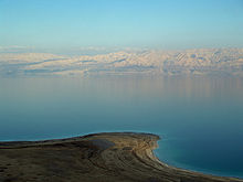
The film also shares the Dead Sea's Biblical history. Located on the border of Israel, King Herod used it as his spa, and King David made it his retreat. But more ominously, the Dead Sea is said to have witnessed the extreme, supernatural fire that violently destroyed the sinners in Sodom and Gomorrah.
Centuries later the climate surround the Dead Sea is still arid and parched. The filmmaker asks how the blessed Jordan River, which the Hebrews crossed to get into the Promised Land and is surrounded by beautiful banana groves, could feed into this unholy, salty lake.

The Dead Sea, also known by other names, is a salt lake bordered by Jordan to the east and Israel and the West Bank to the west. It lies in the Jordan Rift Valley, and its main tributary is the Jordan River.

The geography of Egypt relates to two regions: North Africa and Southwest Asia.

The geography of Israel is very diverse, with desert conditions in the south, and snow-capped mountains in the north. Israel is located at the eastern end of the Mediterranean Sea in Western Asia. It is bounded to the north by Lebanon, the northeast by Syria, the east by Jordan and the West Bank, and to the southwest by Egypt. To the west of Israel is the Mediterranean Sea, which makes up the majority of Israel's 273 km (170 mi) coastline, and the Gaza Strip. Israel has a small coastline on the Red Sea in the south.

The Jordan River or River Jordan, also known as Nahr Al Sharieat, is a 251-kilometre-long (156 mi) river in the Middle East that flows roughly north to south through the Sea of Galilee and on to the Dead Sea. Jordan and the Golan Heights border the river to the east, while the West Bank and Israel lie to its west. Both Jordan and the West Bank take their names from the river.
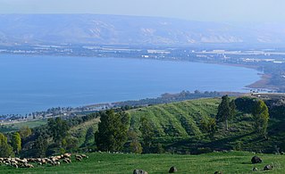
The Sea of Galilee, also called Lake Tiberias, Kinneret or Kinnereth, is a freshwater lake in Israel. It is the lowest freshwater lake on Earth and the second-lowest lake in the world, at levels between 215 metres (705 ft) and 209 metres (686 ft) below sea level. It is approximately 53 km (33 mi) in circumference, about 21 km (13 mi) long, and 13 km (8.1 mi) wide. Its area is 166.7 km2 (64.4 sq mi) at its fullest, and its maximum depth is approximately 43 metres (141 ft). The lake is fed partly by underground springs but its main source is the Jordan River, which flows through it from north to south and exits the lake at the Degania Dam.

An endorheic basin is a drainage basin that normally retains water and allows no outflow to other external bodies of water, such as rivers or oceans, but drainage converges instead into lakes or swamps, permanent or seasonal, that equilibrate through evaporation. They are also called closed or terminal basins, internal drainage systems, or simply basins. Endorheic regions contrast with exorheic regions. Endorheic water bodies include some of the largest lakes in the world, such as the Caspian Sea, the world's largest inland body of water.

The Salton Sea is a shallow, landlocked, highly saline body of water in Riverside and Imperial counties at the southern end of the U.S. state of California. It lies on the San Andreas Fault within the Salton Trough that stretches to the Gulf of California in Mexico. Over millions of years, the Colorado River has flowed into the Imperial Valley and deposited alluvium (soil), creating fertile farmland, building up the terrain, and constantly moving its main course and river delta. For thousands of years, the river has alternately flowed into the valley, or diverted around it, creating either a saline lake called Lake Cahuilla, or a dry desert basin, respectively. When the Colorado River flows into the valley, the lake level depends on river flows and the balance between inflow and evaporative loss. When the river diverts around the valley, the lake dries completely, as it did around 1580. Hundreds of archaeological sites have been found in this region, indicating possibly long-term Native American villages and temporary camps.

The National Water Carrier of Israel is the largest water project in Israel, completed in 1964. Its main purpose is to transfer water from the Sea of Galilee in the north of the country to the highly populated center and arid south and to enable efficient use of water and regulation of the water supply in the country. Up to 72,000 cubic meters of water can flow through the carrier each hour, totalling 1.7 million cubic meters in a day.

The Jordan River, in the state of Utah, United States, is a river about 51 miles (82 km) long. Regulated by pumps at its headwaters at Utah Lake, it flows northward through the Salt Lake Valley and empties into the Great Salt Lake. Four of Utah's six largest cities border the river: Salt Lake City, West Valley City, West Jordan and Sandy. More than a million people live in the Jordan Subbasin, which is the part of the Jordan River watershed that lies within Salt Lake and Utah counties. During the Pleistocene, the area was part of Lake Bonneville.

Sabine Lake is a bay on the Gulf coasts of Texas and Louisiana, located approximately 90 miles (140 km) east of Houston and 160 miles (260 km) west of Baton Rouge, adjoining the city of Port Arthur. The lake is formed by the confluence of the Neches and Sabine Rivers and connects to the Gulf of Mexico through Sabine Pass. It forms part of the Texas–Louisiana border, falling within Jefferson and Orange Counties in Texas and Cameron Parish, Louisiana.

A body of water or waterbody is any significant accumulation of water on the surface of Earth or another planet. The term most often refers to oceans, seas, and lakes, but it includes smaller pools of water such as ponds, wetlands, or more rarely, puddles. A body of water does not have to be still or contained; rivers, streams, canals, and other geographical features where water moves from one place to another are also considered bodies of water.

The Red Sea–Dead Sea Conveyance (RSDSC), sometimes called the Two Seas Canal, was a planned pipeline to run from the coastal city of Aqaba by the Red Sea to the Lisan area in the Dead Sea. Its abandonment was reported in June 2021.

Salt potatoes are a regional dish of Syracuse, New York, typically served in the summer when the young potatoes are first harvested. They are a staple food at fairs and barbecues in the Central New York region, where they are most popular. Potatoes specifically intended for salt potatoes can be purchased by the bag along with packages of salt.

A mud bath is a bath of mud, commonly from areas where hot spring water can combine with volcanic ash. While mud baths have a long traditional heritage that can be traced over thousands of years, they can be found in high-end spas in many countries of the world.
The Mediterranean–Dead Sea Canal (MDSC) is a proposed project to dig a canal from the Mediterranean Sea to the Dead Sea, taking advantage of the 400-metre difference in water level between the seas. The project could correct the drop in the level of the Dead Sea observed in recent years. The canal could also be used to generate hydroelectric power because of surface difference and maybe by salinity gradient power, and desalinate water by reverse osmosis.

Ahava Dead Sea Laboratories, Limited is an Israeli cosmetics company with headquarters in Lod that manufactures skin care products made of mud and mineral-based compounds from the Dead Sea. The company has flagship stores in Israel, Germany, Hungary, South Korea, the Philippines and Singapore. As of 2015, Ahava income was more than US$150 million a year. In 2015, the Chinese conglomerate Fosun International agreed to purchase a controlling share of the company, which has been valuated to ca. NIS 300 million.

A hypersaline lake is a landlocked body of water that contains significant concentrations of sodium chloride or other salts, with saline levels surpassing that of ocean water.
Akyatan Lagoon is a 14700-hectare wetland ecosystem that is designated as Wetland of International Importance by Ramsar Convention. A major stop over for migrating birds, Akyatan is recognized as an Important Bird Area by BirdLife International. It is the single largest green turtle rookery at the Mediterranean, holding 43% of the Mediterranean nesting population.
Geography of the State of Palestine refers to the geographic, climatic and other properties of the areas claimed by State of Palestine.
The Valley of Peace initiative is an effort to promote economic cooperation between Israel, Jordan, and Palestine based around efforts and joint projects in the Arava/Arabah Valley, along which runs the southern portion of the Israel - Jordan border. It received the personal attention and support of Shimon Peres, President of Israel. The initiative involved ongoing joint efforts by regional leaders to launch joint new industrial and economic projects, which will create new local businesses and job growth, and promote ongoing cooperation.