Soil science is the study of soil as a natural resource on the surface of the Earth including soil formation, classification and mapping; physical, chemical, biological, and fertility properties of soils; and these properties in relation to the use and management of soils.

Soil salinity is the salt content in the soil; the process of increasing the salt content is known as salinization. Salts occur naturally within soils and water. Salination can be caused by natural processes such as mineral weathering or by the gradual withdrawal of an ocean. It can also come about through artificial processes such as irrigation and road salt.

Soil classification deals with the systematic categorization of soils based on distinguishing characteristics as well as criteria that dictate choices in use.

Mollisol is a soil type which has deep, high organic matter, nutrient-enriched surface soil, typically between 60 and 80 cm in depth. This fertile surface horizon, called a mollic epipedon, is the defining diagnostic feature of Mollisols. Mollic epipedons are created by long-term addition of organic materials derived from plant roots and typically have soft, granular soil structure.

Wageningen University & Research is a public research university in Wageningen, Netherlands, specializing in life sciences with a focus on agriculture, technical and engineering subjects. It is a globally important center for life sciences and agricultural research. It is located in a region of the Netherlands known as the Food Valley.

The World Reference Base for Soil Resources (WRB) is an international soil classification system for naming soils and creating legends for soil maps. The currently valid version is the fourth edition 2022. It is edited by a working group of the International Union of Soil Sciences (IUSS).
Digital soil mapping (DSM) in soil science, also referred to as predictive soil mapping or pedometric mapping, is the computer-assisted production of digital maps of soil types and soil properties. Soil mapping, in general, involves the creation and population of spatial soil information by the use of field and laboratory observational methods coupled with spatial and non-spatial soil inference systems.

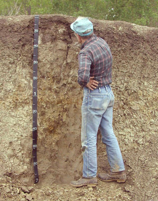
A soil map is a geographical representation showing diversity of soil types or soil properties in the area of interest. It is typically the result of a soil survey inventory, i.e. soil survey. Soil maps are most commonly used for land evaluation, spatial planning, agricultural extension, environmental protection and similar projects. Traditional soil maps typically show only general distribution of soils, accompanied by the soil survey report. Many new soil maps are derived using digital soil mapping techniques. Such maps are typically richer in context and show higher spatial detail than traditional soil maps. Soil maps produced using (geo)statistical techniques also include an estimate of the model uncertainty.
The Food and Agriculture Organization Corporate Statistical Database (FAOSTAT) website disseminates statistical data collected and maintained by the Food and Agriculture Organization (FAO). FAOSTAT data are provided as a time-series from 1961 in most domains for 245 countries in English, Spanish and French.

ISRIC - World Soil Information, also known as the International Soil Reference and Information Centre, is a science-based independent foundation. It was established in 1966, following a recommendation by the International Society of Soil Science and the United Nations Educational, Scientific and Cultural Organization (UNESCO). ISRIC's role is to compile and disseminate information regarding soil resources globally, contributing to the understanding and resolution of key global issues.
European Digital Archive on Soil Maps(EuDASM) is a digital inventory of the maps holding valuable information pertaining to soil that are highly demanded in various environmental assessment studies focusing on policy issues. The EuDASM is a common platform established by Joint Research Centre in Italy of the European Commission and the International Soil Reference and Information Centre(ISRIC) of Wageningen University in The Netherlands to store soil and related maps in digital format and to provide free access to the global community. The archive is typically unique at the present times, for it is the only archive that holds nearly 6000 maps online related to soils and are freely accessible to the public around the world. Moreover, the major focus of the EuDASM initiative is towards the developing nations of Africa, South America, Asia etc., in order to assist them to arrest the loss of existing information and prevent the quality deterioration.

A petrocalcic horizon is a diagnostic horizon in the USDA soil taxonomy (ST) and in the World Reference Base for Soil Resources (WRB). They are formed when secondary calcium carbonate or other carbonates accumulate in the subsoil to the extent that the soil becomes cemented into a hardpan. Petrocalcic horizons are similar to a duripan and a petrogypsic horizon (WRB) in how they affect land-use limitations. They can occur in conjunction with duripans where the conditions are right and there are enough free carbonates in the soil. Calcium carbonates are found in alkaline soils, which are typical of arid and semiarid climates. A common field test for the presence of carbonates is application of hydrochloric acid to the soil, which indicates by fizzing and bubbling the presence of calcium carbonates.

A Durisol is a Reference Soil Group under the World Reference Base for Soil Resources (WRB) referring to free-draining soils in arid and semi-arid environments that contain grains cemented together by secondary silica (SiO2) in the upper metre of soil, occurring either as concretions (durinodes – duric horizon) or as a continuously cemented layer (duripan – hardpan (Australia) – dorbank (South Africa) – petroduric horizon). The name is derived from Latin durus for hard.
AGRIS is a global public domain database with more than 12 million structured bibliographical records on agricultural science and technology. It became operational in 1975 and the database was maintained by Coherence in Information for Agricultural Research for Development, and its content is provided by more than 150 participating institutions from 65 countries. The AGRIS Search system, allows scientists, researchers and students to perform sophisticated searches using keywords from the AGROVOC thesaurus, specific journal titles or names of countries, institutions, and authors.
Soil governance refers to the policies, strategies, and the processes of decision-making employed by nation states and local governments regarding the use of soil. Globally, governance of the soil has been limited to an agricultural perspective due to increased food insecurity from the most populated regions on earth. The Global Soil Partnership, GSP, was initiated by the Food and Agriculture Organization (FAO) and its members with the hope to improve governance of the limited soil resources of the planet in order to guarantee healthy and productive soils for a food-secure world, as well as support other essential ecosystem services.

Kerala Soil Museum is a museum on the premises of Central Soil Analytical Laboratory at Parottukonam, Thiruvananthapuram District, in the Indian state of Kerala. The museum displays the diverse types of soil in the state. It was set up by the Department of Soil Survey and Conservation of Government of Kerala and inaugurated on 1 January 2014. It has been described as the world's largest soil museum and the first soil museum in India established to international standards.

Nitisol, in the World Reference Base for Soil Resources (WRB), is a deep, red, well-drained soil with a clay content of at least 30% and a polyhedral structure or a blocky structure, breaking into a polyhedral or a flat-edged structure. The soil aggregates show pressure faces. Nitisols correlate with the kandic alfisols, ultisols and inceptisols of the USDA soil taxonomy.

A Phaeozem in the World Reference Base for Soil Resources (WRB) is a dark soil with a high base status, but without a secondary carbonates within one metre of the soil surface. Most Phaeozems correlate with the Udolls (Mollisols) of the USDA soil taxonomy.

Salt tolerance of crops is the maximum salt level a crop tolerates without losing its productivity while it is affected negatively at higher levels. The salt level is often taken as the soil salinity or the salinity of the irrigation water.

