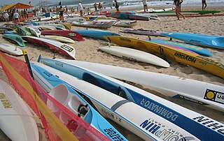
Surf lifesaving is a multifaceted social movement that comprises key aspects of voluntary lifeguard services and competitive surf sport. Originating in early 20th century Australia, the movement has expanded globally to other countries, including New Zealand, Ireland, South Africa, and the United Kingdom. Surf lifesavers in Australia are colloquially known as "Clubbies".

Wellington City Council is a territorial authority in New Zealand, governing the country's capital city Wellington, and de facto second-largest city. It consists of the central historic town and certain additional areas within the Wellington metropolitan area, extending as far north as Linden and covering rural areas such as Mākara and Ohariu. The city adjoins Porirua in the north and Hutt City in the north-east. It is one of nine territorial authorities in the Wellington Region.

Miramar is a suburb of Wellington, New Zealand, south-east of the city centre. It is on the Miramar Peninsula, directly east of the isthmus of Rongotai, the site of Wellington International Airport.

Te Motu Kairangi / Miramar Peninsula is a large peninsula on the southeastern side of the city of Wellington, New Zealand. It is located at the entrance to Wellington Harbour, in Wellington's eastern suburbs. According to Māori legend, it was formed when the taniwha Whaitaitai beached as he tried to escape the confines of the harbour. It contains the suburb of Miramar.

Seatoun, an eastern suburb of Wellington, the capital city of New Zealand, lies on the east coast of the Miramar Peninsula, close to the entrance to Wellington Harbour, some seven kilometres southeast of the CBD. The suburb sits on an exposed promontory close to Barrett Reef, a dangerous area of rocky shallows upon which many ships have foundered, most notably the inter-island ferry TEV Wahine in 1968.
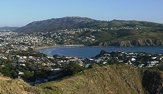
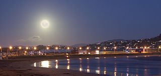
Tītahi Bay, a suburb of Porirua in the North Island of New Zealand, lies at the foot of a short peninsula on the west coast of the Porirua Harbour, to the north of Porirua city centre.
Surf Life Saving Northern Region is the largest of four regions that make up Surf Life Saving New Zealand. As of the 2021/2022 season, it is made up of 18 clubs that look after 22 patrol locations from Ahipara to Raglan on the West Coast and from Whangārei Heads to Takapuna on the East Coast.
Surf Life Saving New Zealand (SLSNZ) is the national association representing 74 Surf Life Saving Clubs in New Zealand. The organisation's motto is 'In it for Life'. This refers to both the long relationship many members have with the organisation, as well as to the organisation's purpose of preventing drowning and injury, thereby saving lives.

Ruapuke is a small farming community in the Waikato region on the slopes of Karioi, between Raglan and Kawhia in New Zealand.
Idle-Along (IA) - is a class of sailing dinghy designed by Alf (Unc) Harvey at Petone in 1927. It grew to considerable popularity in the 1950s but its popularity gradually diminished during the 1960s. A redesigned hull for plywood construction by John Spencer kept the class going but on a smaller scale with a small revival in the 1990s with about 10 new boats being built. The Idle-Along is also sometimes referred to as IdleAlong, Idle Along, IA, I Class and Idie.
Zeddie is an old New Zealand sailing dinghy. The first boat was designed and built by Mr R.B. Brown at Northcote in the 1920s. The Zeddie originally was gunter rigged, which shortened the spars for convenience. Some have been converted to Bermudan, no jib and a spinnaker which was sheeted around the front of the mast leading to many capsizes. This rule was changed in the interests of safety. The Zeddie is 12 foot 6 inches long and about 5 foot in the beam.
Lyall Bay is a bay and suburb on the south side of the Rongotai isthmus in Wellington, New Zealand.

Breaker Bay is a suburb on the south east coast of Wellington City in New Zealand, on the Miramar Peninsula. The suburb contains a 600 m wide bay of the same name.

Mākara is a locality located at the western edge of Wellington, New Zealand, close to the shore of the Tasman Sea. The suburb is named after the Mākara Stream.

Westshore is a northern coastal suburb of the city of Napier in Hawke's Bay, New Zealand.

Evans Bay is a large bay at the southern end of Wellington Harbour, New Zealand. Located between the Miramar Peninsula and Hataitai, it was the site of New Zealand's first patent slip and served as Wellington's international flying-boat terminal from 1938 until 1956. It is named after George Samuel Evans, an early Wellington settler.

Strathmore Park is a suburb of Wellington City, New Zealand. It is located at the southern end of the Miramar Peninsula to the south of the suburb of Miramar, and due east of the airport. A hill suburb, it overlooks Lyall Bay, Evans Bay and several bays along the Seatoun coast close to the mouth of Wellington Harbour, which lies to the east.

Karaka Bays is a suburb of Wellington, New Zealand. It lies on the northeast coast of the Miramar Peninsula, 6 km east-south-east of the city centre, and has an expansive view of Wellington Harbour. It takes its name from a New Zealand native tree, the karaka or New Zealand laurel.

Maupuia on the Miramar Peninsula is an eastern suburb of Wellington to the north-west of Miramar. Developed in the 1970s, it is in the Eastern Ward.
Omanu is a beach and suburb in Mount Maunganui, Tauranga, in the Bay of Plenty Region of New Zealand's North Island.

