Trinidad and Tobago, a country that relies heavily on industrialisation and tourism, has various transport systems.

Port of Spain, officially the City of Port of Spain, is the capital of Trinidad and Tobago and the third largest municipality, after Chaguanas and San Fernando. The city has a municipal population of 37,074 (2011), an urban population of 81,142 and a transient daily population of 250,000. It is located on the Gulf of Paria, on the northwest coast of the island of Trinidad and is part of a larger conurbation stretching from Chaguaramas in the west to Arima in the east with an estimated population of 600,000.

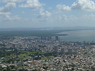
San Fernando, officially the City of San Fernando, is the most populous city and second most populous municipality in Trinidad and Tobago, after Chaguanas. Sando, as it is known to many local Trinidadians, occupies 19 km2 and is located in the southwestern part of the island of Trinidad. It is bounded to the north by the Guaracara River, the south by the Oropouche River, the east by the Sir Solomon Hochoy Highway, and the west by the Gulf of Paria. The former borough was elevated to the status of a city corporation on 18 November 1988. The motto of San Fernando is: "Sanitas Fortis" - In a Healthy Environment We Will Find Strength. San Fernando is called Trinidad and Tobago's "industrial capital" because of its proximity to the Pointe-à-Pierre oil refinery and many other petrochemical, LNG, iron and steel and aluminium smelters in places such as Point Lisas in Couva, Point Fortin, and La Brea.

The Borough of Chaguanas is the largest municipality and fastest-growing town in Trinidad and Tobago. Located in west-central Trinidad, south of Port of Spain, north of Couva and San Fernando, and named after the indigenous tribe who originally settled there, it grew in size due to its proximity to the Woodford Lodge sugar refinery. It remained a minor town until the 1980s when it began to grow rapidly as it drew people for its bargain shopping and moderately priced housing. Its rapid growth has seen property values increase dramatically, however.

Arima, officially The Royal Chartered Borough of Arima is the easternmost and second largest in area of the three boroughs of Trinidad and Tobago. It is geographically adjacent to Sangre Grande and Arouca at the south central foothills of the Northern Range. To the south is the Caroni–Arena Dam. Coterminous with Town of Arima since 1888, the borough of Arima is the fourth-largest municipality in population in the country. The census estimated it had 33,606 residents in 2011.

Barataria is a neighbourhood in Trinidad and Tobago located in San Juan. It is east of Port of Spain and Laventille and west of the San Juan town centre. It is part of the East–West Corridor.

The Sir Solomon Hochoy Highway, sometimes referred to as SHH, is the major north–south highway on the island of Trinidad, in Trinidad and Tobago. It runs for 51.2 km.
The Uriah Butler Highway, sometimes referred to as UBH, is one of the major north–south highways on Trinidad in Trinidad and Tobago.
The Beetham Highway is a major highway in Trinidad and Tobago. It runs from downtown Port of Spain where it meets Wrightson Road to Barataria. It was constructed between 1955 and 1956.

The Audrey Jeffers Highway is a highway in Trinidad and Tobago. It runs west from Downtown Port of Spain to Cocorite. The highway runs from the Hasely Crawford Stadium to the Cocorite area parallel to Mucurapo Road and the Western Main Road in St. James. It is named in honour of Audrey Jeffers, a social worker and Trinidad and Tobago's first female Member of Parliament.
Audrey Layne Jeffers CM, OBE was a Trinidadian social worker and the first female member of the Legislative Council of Trinidad and Tobago.
Malabar is a diverse neighbourhood in South Arima, in Trinidad and Tobago. It is noted for middle class housing. Its boundaries are marked by Omeara Road to the west, Tumpuna Road to the east, the Churchill-Roosevelt Highway to the south and Pro Queen Street to the north. One of its main streets, Subero Street extends southward into Malabar from Pro Queen Street into the Malabar housing project and ends at Nutones Boulevard, which runs along the northern boundary of the O'meara Industrial Estate. The other main street is the Malabar Road. The western part of Malabar seems to overlap with what was once the La Chance estate, which was founded by Gaston de Gannes de La Chancellerie in the 1840s. The La Chance estate house is located on O'Meara Rd and currently houses the Acoté veterinary clinic.

The Port of Spain International Waterfront Centre is a construction project aimed at revitalising and transforming the waterfront of the capital-city Port of Spain located in Trinidad and Tobago. The project is a part of the overall Vision 2020, a government policy attempting to take Trinidad and Tobago to developed country status by 2020. That policy has since been shelved. The towers, which were supposed to usher in the beginning of a "Financial Centre" never materialized, and have slowly been occupied by government departments and offices.

TTPost is the Trinidad and Tobago postal corporation, responsible for the postal services in Trinidad and Tobago.
Downtown Port of Spain is the central business district of Port of Spain, Trinidad and Tobago. The largest of the city's 7 commercial districts. The Downtown district of Port of Spain is also the oldest district of the city, between South Quay, Oxford Street, the St. Ann's River, and Richmond Street.
The Claude Noel Highway, sometimes referred to as CNH, is one of the major west–east highways in Trinidad and Tobago, named after Claude Noel, it is the only highway in Tobago. It runs from Canaan to Scarborough.
The Diego Martin Highway is a highway in Trinidad and Tobago. It runs west from Cocorite to Diamond Vale. The highway meets the Audrey Jeffers Highway in Cocorite and runs north–south to Wendy Fitzwillliam Boulevard in Diamond Vale.
The Coterie of Social Workers is a women's organization, established in 1921 in Trinidad and Tobago, British West Indies to engage in empowering women as well as providing benevolent assistance to the poor and disadvantaged. It was the first organization to target for membership, middle-class women of colour and focus on the needs of working class women, regardless of their marital status and was the leading women's organization in the country from its establishment through the 1940s. Though it has branches throughout the country, its headquarters is located at 3 Longden Street in Port of Spain.
The South Trunk Road is a major arterial road on the island of Trinidad, in Trinidad and Tobago. It runs for 13.5 km.
