Related Research Articles

Storm tides of the North Sea are coastal floods associated with extratropical cyclones crossing over the North Sea, the severity of which are affected by the shallowness of the sea and the orientation of the shoreline relative to the storm's path, as well as the timing of tides. The water level can rise to more than 5 metres (17 ft) above the normal tide as a result of storm tides.

The 1938 New England Hurricane was one of the deadliest and most destructive tropical cyclones to strike Long Island, New York, and New England. The storm formed near the coast of Africa on September 9, becoming a Category 5 hurricane on the Saffir–Simpson hurricane scale, before making landfall as a Category 3 hurricane on Long Island on Wednesday, September 21. It is estimated that the hurricane killed 682 people, damaged or destroyed more than 57,000 homes, and caused property losses estimated at $306 million. Multiple other sources, however, mention that the 1938 hurricane might have really been a more powerful Category 4, having winds similar to Hurricanes Hugo, Harvey, Frederic and Gracie when it ran through Long Island and New England. Also, numerous others estimate the real damage between $347 million and almost $410 million. Damaged trees and buildings were still seen in the affected areas as late as 1951. It remains the most powerful and deadliest hurricane in recorded New England history, perhaps eclipsed in landfall intensity only by the Great Colonial Hurricane of 1635.

Zeebrugge is a village on the coast of Belgium and a subdivision of Bruges, for which it is the modern port. Zeebrugge serves as both the international port of Bruges-Zeebrugge and a seafront resort with hotels, cafés, a marina and a beach.

Hurricane Gloria was a powerful hurricane that caused significant damage along the east coast of the United States and in Atlantic Canada during the 1985 Atlantic hurricane season. It was the first significant tropical cyclone to strike the northeastern United States since Hurricane Agnes in 1972 and the first major storm to affect New York City and Long Island directly since Hurricane Donna in 1960. Gloria was a powerful Cape Verde hurricane originating from a tropical wave on September 16 in the eastern Atlantic Ocean. After remaining a weak tropical cyclone for several days, Gloria intensified into a hurricane on September 22 north of the Lesser Antilles. During that time, the storm had moved generally westward, although it turned to the northwest due to a weakening of the ridge. Gloria quickly intensified on September 24, and the next day reached peak winds of 145 mph (230 km/h). The hurricane weakened before striking the Outer Banks of North Carolina on September 27. Later that day, Gloria made two subsequent landfalls on Long Island and across the coastline of western Connecticut, before becoming extratropical on September 28 over New England. The remnants moved through Atlantic Canada and went on to impact Western Europe, eventually dissipating on October 4.
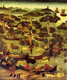
The All Saints' Flood of 1570 occurred on November 1–2, 1570, and is considered the worst North Sea flood disaster before the 20th century. It flooded the entire coast of the Netherlands and East Frisia. The effects were felt from Calais in Flanders to Jutland and even Norway.Even though the alleged casualty figures were mostly based on rough estimates and should be viewed with skepticism, up to 25,000 deaths can be assumed.
The St. Elizabeth's flood of 1404 occurred on or around 19 November 1404, the namesake day of St. Elizabeth. The floods were especially catastrophic in Flanders, Zeeland and Holland.The area in Zeeland and Flanders had been flooded 29 years earlier, on 8 October 1375. As a result of the floods, the Braakman was created or enlarged. In this new area, new parishes and villages started to appear. The flood in 1404 destroyed the area again, just as it had done in 1375. Other areas previously untouched such as the small towns of IJzendijke and Hugevliet were engulfed and destroyed during the flood. When the flood occurred many were killed and homes destroyed due to the poor warnings.
The St. Elizabeth's flood of 1421 was a flooding of the Grote Hollandse Waard, an area in what is now the Netherlands. It takes its name from the feast day of Saint Elisabeth of Hungary which was formerly 19 November. It ranks 20th on the list of worst floods in history. During the night of 18/19 November 1421 a heavy storm near the North Sea coast caused the dikes to break in a number of places and the lower-lying polder land was flooded. A number of villages were swallowed by the flood and were lost, causing between 2,000 and 10,000 casualties. The dike breaks and floods caused widespread devastation in Zeeland and Holland.

The Braakman was a large tidal inlet in the middle of the Dutch region of Zeelandic Flanders, on the south bank of the Westerschelde west of Terneuzen.

The 1821 Norfolk and Long Island Hurricane was one of four known tropical cyclones that have made landfall in New York City. Another, even more intense hurricane in pre-Columbian times left evidence that was detected in South Jersey by paleotempestological research. The third was the 1893 New York hurricane, and the fourth was Hurricane Irene in 2011.

The Battle of Beverhoutsveld took place on 3 May 1382, on a field situated between the towns of Beernem, Oostkamp and Assebroek. It marked an important phase in the rebellion of Ghent against Louis II, Count of Flanders.

The effects of Hurricane Isabel in Maryland and Washington, D.C., were among the most damaging from a tropical cyclone in the Baltimore-Washington Metropolitan Area, United States. Hurricane Isabel formed from a tropical wave on September 6, 2003, in the tropical Atlantic Ocean. It moved northwestward, and within an environment of light wind shear and warm waters, it steadily strengthened to reach peak winds of 165 mph (265 km/h) on September 11. After fluctuating in intensity for four days, Isabel gradually weakened and made landfall on the Outer Banks of North Carolina with winds of 105 mph (165 km/h) on September 18. It quickly weakened over land and became extratropical over western Pennsylvania the next day.
Maele Castle, Bruges Maele Castle is a former castle in Male, once a separate village, now part of Sint-Kruis, a suburb of Bruges, West Flanders, Belgium. The buildings, almost entirely rebuilt and restored after the destruction of World War II, have housed St. Trudo's Abbey (Sint-Trudoabdij) from 1954 until 2011.
The Schipdonk Canal is a canal in the Belgian provinces of East Flanders and West Flanders. With a length of 56 km (35 mi), the canal runs in a northerly direction from Deinze, turning to a north-western direction roughly halfway along its route to the North Sea with which it meets on the coast near to Heist. It crosses both the Ghent-Bruges Canal and for its final 20 km (12 mi) runs parallel with the Leopold Canal as it approaches the north Belgian coast. For most of this final section the two canals are separated only by a dyke.

The November 2011 Bering Sea cyclone was one of the most powerful extratropical cyclones to affect Alaska on record. On November 8, the National Weather Service (NWS) began issuing severe weather warnings, saying that this was a near-record storm in the Bering Sea. It rapidly deepened from 973 mb (28.7 inHg) to 948 mb (28.0 inHg) in just 24 hours before bottoming out at 943 mbar, roughly comparable to a Category 3 or 4 hurricane. The storm had been deemed life-threatening by many people. The storm had a forward speed of at least 60 mph (97 km/h) before it had reached Alaska. The storm began affecting Alaska in the late hours of November 8, 2011. The highest gust recorded was 93 mph (150 km/h) on Little Diomede Island. One person was reported missing after being swept into the Bering Sea, and he was later pronounced dead.

Bruges is the capital and largest city of the province of West Flanders in the Flemish Region of Belgium, in the northwest of the country, and the sixth-largest city of the country by population.

Burg Square is a square and former fortress in Bruges. It is one of the main squares of the city.
References
- ↑ Augustyn, Beatrijs. "Evolution of the dune ecosystem in Flanders during the Middle Ages :anthropogenic factors versus sea level change theory" (PDF). Archived from the original (PDF) on 9 July 2006. Retrieved 1 November 2022.