Wulveringem is a small agricultural and residential village in the Westhoek region of West Flanders, a short distance from the border with French Flanders. Wulveringem has a land area of 9.37 km2: in 2011 there were 336 registered inhabitants.
Administratively Wulveringem has been controlled from Veurne since 1977. It was independently administered till 1971 after which, between 1971 and 1977, it was combined for administrative purposes with the adjacent village of Vinkem to form a new administrative unit called Beauvoorde. Although Beauvoorde's status as an independent administrative unit was short-lived, the name Beauvoorde continues in daily use.
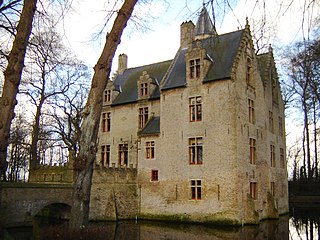
The village also features the historic Beauvoorde Castle, originally dating back to the 12th century and rebuilt in the Flemish Renaissance style in the early 1600s. [1] The castle was built by Jacob de Bryarde, bailiff of Veurne, around 1600, replacing an earlier non-fortified mansion that had been burned down by beggars in 1584. The new castle was designed by architect Sylvain Boullain. [2]
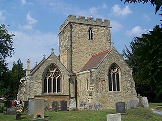
During World War II, the village churchyard became the final resting place for 15 Commonwealth soldiers, a testament to its involvement in the defense of Belgium in May 1940. [3]
History
Wulveringem appears on a map from 1770 on which it is identified as "Wulveringhem". The village was barely smaller than it is today. The centre in 1770 consisted of 55 buildings, and well beyond the centre there were a number of large and small farms. The land is flat and often damp: about ten of the Wulveringem farms were partially or completely surrounded by moats. The church and the small cemetery around it were almost wholly circled by a moat as were two adjacent farms.
Population decline since 1830
The registered population peaked in 1830 at 1,080 before the lure of higher wages in the industrializing towns and the mechanisation of agriculture led to a slow decline, to 822 in 1910. The population rose significantly by 1920, but then continued to decline, reaching 508 in 1970 and 336 in 2011.
Visiting Wulveringem
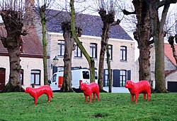
The centre of the village has been carefully preserved/restored. It is sometimes possible to visit Beauvoorde Castle which is positioned across a moat to the south side of the church yard.
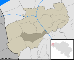
Veurne is a city and municipality in the Belgian province of West Flanders. The municipality comprises the town of Veurne proper and the settlements of Avekapelle, Booitshoeke, Bulskamp, De Moeren (Belgium), Eggewaartskapelle, Houtem, Steenkerke, Vinkem, Wulveringem, and Zoutenaaie.
Llantwit Major is a town and community in Wales on the Bristol Channel coast. It is one of four towns in the Vale of Glamorgan, with the third largest population after Barry and Penarth, and ahead of Cowbridge. It is 4+1⁄2 miles (7.2 km) from Cowbridge, 9 miles (14 km) from Bridgend, 10 miles (16 km) from Barry, and 15 miles (24 km) from Cardiff. It had a population of 9,530 in 2021.
Lingfield is a village and civil parish in the Tandridge district of Surrey, England, approximately 23 miles (37 km) south of London. Several buildings date from the Tudor period and the timber-frame medieval church is Grade I listed. The stone cage or old gaol, constructed in 1773, was last used in 1882 to hold a poacher.
Hermitage is a village and civil parish, near Newbury, in the English county of Berkshire. The civil parish is made up of a number of settlements: Hermitage village, Little Hungerford and Wellhouse.
Spilsby is a market town and civil parish in the East Lindsey district of Lincolnshire, England. The town is adjacent to the main A16, 33 miles (53 km) east of Lincoln, 17 miles (27 km) north-east of Boston and 13 miles (21 km) north-west of Skegness. It lies at the southern edge of the Lincolnshire Wolds and north of the Fenlands.
Castle Bromwich is a large suburban village and civil parish in the Metropolitan Borough of Solihull in the West Midlands, England. It borders the rest of the borough to the south east, Sutton Coldfield to the east and north east, Shard End to the south west, Castle Vale, Erdington and Minworth to the north and Hodge Hill to the west.
Colwinston is both a village and a community in the Vale of Glamorgan, Wales, approximately 4 miles (6.4 km) southeast of the centre of Bridgend and 21 miles (34 km) west of the centre of Cardiff. The village is located within 1⁄2 mile (0.80 km) of the A48. The population in 2005 was approximately 400 but with recent building development, the population is now estimated at over 600 people.
Blakedown is a village in the Wyre Forest District lying along the A456 in the north of the county of Worcestershire, England. Following enclosures and the arrival of the railway, it developed both agriculturally and industrially during the 19th century. Due to its transport links, it now serves mainly as a dormitory for the neighbouring town of Kidderminster and for the cities of Birmingham and Worcester.
Acton is a small village and former civil parish, now in the parish of Burland and Acton, lying immediately west of the town of Nantwich, in the unitary authority area of Cheshire East and the ceremonial county of Cheshire, England. The civil parish covered 762 acres (3.08 km2) and also included the small settlement of Dorfold and part of Burford, with an estimated population of 340 in 2006. It is administered jointly with the adjacent civil parishes of Henhull and Edleston. Historically, Acton refers to a township and also to an ancient parish in the Nantwich Hundred covering a wide area to the west of Nantwich. The area is agricultural, with dairy farming the main industry. Around a third of the area falls within the Dorfold Estate. Historically, agriculture was the major employer, but it has now been overtaken by the service industries, with many residents commuting significant distances outside the parish to work.
Appleby Magna is a village and civil parish in the North West Leicestershire district, in the county of Leicestershire, England. It includes the small hamlets of Appleby Parva and Little Wigston.
Barton Seagrave is a large village and civil parish in the North Northamptonshire, England. The village is about 1.5 miles (2.4 km) south-east of Kettering, town centre. The older part of the village is known for its Norman Church and attractive buildings.
Innerwick is a coastal civil parish and small village, which lies in the east of East Lothian, five miles from Dunbar and approximately 32 miles from Edinburgh.
Peckforton is a scattered settlement and civil parish in the unitary authority of Cheshire East and the ceremonial county of Cheshire, England. The settlement is located 6.5 miles (10.5 km) to the north east of Malpas and 7.5 miles (12.1 km) to the west of Nantwich. The civil parish covers 1,754 acres (710 ha), with an estimated total population of 150 in 2006. The area is predominantly agricultural. Nearby villages include Bulkeley to the south, Beeston to the north, Higher Burwardsley to the west, Spurstow to the east and Bunbury to the north east.
Hermitage Manor is a small manor house in Warwickshire (UK) with a trihedral moat, associated land and farm. A manor house or fortified manor-house is a country house, which has historically formed the centre of a manor. The term is sometimes applied to relatively small country houses which belonged to gentry families, as well as to grand stately homes, particularly as a technical term for minor late medieval castles more intended for show than for defence.
Seale is a village in Surrey, England. Seale covers most of the civil parish of Seale and Sands and the steep slope and foot of the south side of the Hog's Back as well as a large hill which exceeds it – as such is part of the Surrey Hills Area of Outstanding Natural Beauty.
St Michael and All Angels Church is a church in Lowfield Heath, a depopulated former village in the Borough of Crawley, West Sussex, England. Built by the Gothic Revival architect William Burges in 1867 to serve the village, it declined in importance as Lowfield Heath was gradually appropriated for the expansion of London Gatwick Airport and of its related development. The last Anglican service was held there in 2004, but the church reopened in 2008 as a Seventh-day Adventist place of worship. The building has Grade II* listed status, which identifies it as a "particularly important building of more than special interest" and of national importance. It is also the only building remaining in the former village from the era before the airport existed: every other structure was demolished, and the church now stands among warehouses, depots and light industrial units.
Beauvoorde Castle is a castle in Wulveringem, which since 1977 has been part of the municipality of Veurne, West Flanders, Belgium.
Dunton Wayletts or Dunton is a hamlet and former civil parish in the Borough of Basildon in Essex, England. It lies on the western outskirts of the borough's main town of Basildon, adjoining the suburb of Laindon.
The Vale of Glamorgan has 740 listed buildings of which 4% are Grade I listed, 10% Grade II* listed and remainder Grade II listed.
Beveren-aan-de-IJzer is a village in the municipality of Alveringem in the Belgian province of West Flanders. The village is located near the border with France, and was therefore called Beveren aan de Franse grens during the 19th century. Until 1971, Beveren-aan-de-IJzer was an independent municipality.
This page is based on this Wikipedia article Text is available under the CC BY-SA 4.0 license; additional terms may apply. Images, videos and audio are available under their respective licenses.