
The Auckland Harbour Bridge is an eight-lane motorway bridge over the Waitematā Harbour in Auckland, New Zealand. It joins St Marys Bay on the Auckland city side with Northcote on the North Shore side. It is part of State Highway 1 and the Auckland Northern Motorway. The bridge is operated by the NZ Transport Agency (NZTA). It is the second-longest road bridge in New Zealand, and the longest in the North Island.

Auckland City was a territorial authority with city status covering the central isthmus of the urban area of Auckland, New Zealand. It was governed by the Auckland City Council from 1989 to 2010, and as a territory within the wider Auckland Region, was also governed by Auckland Regional Council. Auckland City was disestablished as a local authority on 1 November 2010, when Auckland City Council was amalgamated with other councils of the Auckland Region into the new Auckland Council. At the time of its disestablishment, the city had a resident population of around 450,000.

Māngere Bridge, officially also called the Manukau Harbour Crossing, is a dual motorway bridge over the Manukau Harbour in south-western Auckland, New Zealand, crossing between the suburb also known as Māngere Bridge and the suburb of Onehunga.

Viaduct Harbour, formerly known as Viaduct Basin, is a former commercial harbour on the Auckland waterfront that has been turned into a development of mostly upscale apartments, office space and restaurants. It is located on the site of a formerly run-down area of the Freemans Bay / Auckland CBD waterfront in Auckland, New Zealand. As a centre of activity of the 2000 America's Cup hosted by the Royal New Zealand Yacht Squadron, as well as the 2022 Rally New Zealand, the precinct enjoyed considerable popularity with locals and foreign visitors.
Transport in Auckland, New Zealand's largest city, is defined by factors that include the shape of the Auckland isthmus, the suburban character of much of the urban area, a history of focusing investment on roading projects rather than public transport, and high car-ownership rates.

The Auckland Northern Motorway in the Auckland Region of New Zealand links Central Auckland and Warkworth in the former Rodney District via the Hibiscus Coast and North Shore. It is part of State Highway 1.

Princes Wharf is a former commercial wharf on the Auckland waterfront, in Auckland, New Zealand, which has been redeveloped into a multi-story high-class mixed-use development and cruise ship terminal.

Ports of Auckland Limited (POAL), the successor to the Auckland Harbour Board, is the Auckland Council-owned company administering Auckland's commercial freight and cruise ship harbour facilities. As the company operates all of the associated facilities in the Greater Auckland area, this article is about both the current company and the ports of Auckland themselves.

The Wynyard Quarter is a reclaimed piece of land on the Waitematā Harbour at the western edge of the Auckland waterfront, New Zealand.

The Auckland waterfront is a city-side stretch of the southern Waitematā Harbour coastline in Auckland, New Zealand. Previously mostly dominated by Ports of Auckland uses, from the 2000s on it is becoming increasingly open to recreational public use, with a number of former wharves being converted to office, entertainment, and later also some residential uses.

Westhaven Marina in Auckland, New Zealand, is the largest yacht marina in the Southern Hemisphere. The marina has nearly two thousand berths and swing moorings, and tends to be continually booked. Auckland, known as 'City of Sails', is generally known for its maritime passions.

The Auckland Central Business District (CBD), or Auckland city centre, is the geographical and economic heart of the Auckland metropolitan area. It is the area in which Auckland was established in 1840, by William Hobson on land gifted by mana whenuahapū Ngāti Whātua Ōrākei. It is New Zealand's leading financial hub, and the centre of the country's economy; the GDP of the Auckland Region was NZD$139 billion in the year ending September 2023.

The Victoria Park Viaduct is a major motorway viaduct carrying the Auckland Northern Motorway over the Victoria Park area in the Auckland city centre, New Zealand. Construction began in 1959, and the bridge was opened on 5 April 1962. Due to the high traffic volumes passing through on their way to and from North Shore City, and because the viaduct is only four lanes wide in total, the bridge over the park is considered "one of the country's worst traffic bottlenecks", with around 200,000 vehicles a day.

Trams in New Zealand were a major form of transport from the 19th century into the mid-20th century. New Zealand's first (horse) tramway was established in 1862 (Nelson), followed by a steam tramway in 1871 (Thames), and the first electric tramway in 1900. In New Zealand railway terminology a bush tramway is an industrial tramway, which usually did not carry passengers.

The Second Harbour Crossing is the name given to the proposed second transport link across the Waitematā Harbour in Auckland, New Zealand. Planners have also referred to new links across the harbour as the Additional Waitematā Harbour Crossing (AWHC) or the Waitematā Harbour Connections.
Queens Wharf is a concrete wharf in Auckland, New Zealand, that continues off Queen Street. It opened in 1913, replacing the Queen Street Wharf, a succession of wooden wharves first built in 1852. Queens Wharf was owned and used by Ports of Auckland until 2010.
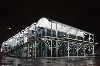
The Viaduct Events Centre is a stand-alone, multi-purpose events centre built on the Halsey Street extension wharf, Wynyard Quarter of Auckland, New Zealand. It was owned and operated by Regional Facilities Auckland, an organisation under the control of Auckland Council. Opened in August 2011 at a cost of approximately $32 million, the 6,000 square metres (65,000 sq ft) facility offered eight separate rooms suitable for a wide range of events including conferences, gala dinners and exhibitions.

The Auckland Airport Line is a proposed heavy rail line in Auckland, New Zealand, that would link Auckland Airport with the Auckland central business district via central isthmus suburbs.

The Nelson Street Cycleway is a cycleway in Auckland, New Zealand. The most well-known section of the path is Te Ara I Whiti, translated as, and commonly known as Lightpath. The cycleway then continues on to the Nelson Street arterial road into the City Centre.
Eke Panuku Development Auckland is one of four council-controlled organisations (CCOs) of Auckland Council in Auckland, New Zealand. Eke Panuku manages a NZD$2.3bn property portfolio of non-core Auckland Council assets.


