
Jędrzejowice is a village in the administrative district of Gmina Dzierżoniów, within Dzierżoniów County, Lower Silesian Voivodeship, in south-western Poland. Prior to 1945 it was in Germany. It lies approximately 16 kilometres (10 mi) north-east of Dzierżoniów and 42 km (26 mi) south-west of the regional capital Wrocław.
Książnica is a village in the administrative district of Gmina Dzierżoniów, within Dzierżoniów County, Lower Silesian Voivodeship, in south-western Poland. Prior to 1945 it was in Germany. It lies approximately 12 kilometres (7 mi) north-east of Dzierżoniów and 47 km (29 mi) south-west of the regional capital Wrocław.
Ligota Wielka is a village in the administrative district of Gmina Łagiewniki, within Dzierżoniów County, Lower Silesian Voivodeship, in south-western Poland. It lies approximately 6 kilometres (4 mi) south-west of Łagiewniki, 18 km (11 mi) east of Dzierżoniów, and 45 km (28 mi) south-west of the regional capital Wrocław.
Kuchary is a village in the administrative district of Gmina Łagiewniki, within Dzierżoniów County, Lower Silesian Voivodeship, in south-western Poland. It lies approximately 8 kilometres (5 mi) west of Łagiewniki, 16 km (10 mi) north-east of Dzierżoniów, and 43 km (27 mi) south-west of the regional capital Wrocław.
Ligota Mała is a village in the administrative district of Gmina Niemcza, within Dzierżoniów County, Lower Silesian Voivodeship, in south-western Poland. Prior to 1945 it was in Germany. It lies approximately 6 kilometres (4 mi) south of Niemcza, 20 km (12 mi) east of Dzierżoniów, and 54 km (34 mi) south of the regional capital Wrocław.
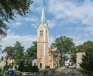
Podlesie is a village in the administrative district of Gmina Niemcza, within Dzierżoniów County, Lower Silesian Voivodeship, in south-western Poland.
Krzepice is a village in the administrative district of Gmina Strzelin, within Strzelin County, Lower Silesian Voivodeship, in south-western Poland. Prior to 1945 it was in Germany. It lies approximately 5 kilometres (3 mi) east of Strzelin and 39 km (24 mi) south of the regional capital Wrocław.
Piotrowice is a village in the administrative district of Gmina Strzelin, within Strzelin County, Lower Silesian Voivodeship, in south-western Poland. Prior to 1945 it was in Germany. It lies approximately 5 kilometres (3 mi) west of Strzelin and 39 km (24 mi) south of the regional capital Wrocław.
Szczawin is a village in the administrative district of Gmina Strzelin, within Strzelin County, Lower Silesian Voivodeship, in south-western Poland. Prior to 1945 it was in Germany. It lies approximately 39 km (24 mi) south of the regional capital Wrocław.
Strachów is a village in the administrative district of Gmina Sobótka, within Wrocław County, Lower Silesian Voivodeship, in south-western Poland. Prior to 1945 it was in Germany. It lies approximately 3 kilometres (2 mi) east of Sobótka and 31 km (19 mi) south-west of the regional capital Wrocław.

Laskówka is a village in the administrative district of Gmina Bardo, within Ząbkowice Śląskie County, Lower Silesian Voivodeship, in south-western Poland. Prior to 1945 it was in Germany. It lies approximately 6 kilometres (4 mi) south-east of Bardo, 12 km (7 mi) south of Ząbkowice Śląskie, and 74 km (46 mi) south of the regional capital Wrocław.
Tarnów is a village in the administrative district of Gmina Ząbkowice Śląskie, within Ząbkowice Śląskie County, Lower Silesian Voivodeship, in south-western Poland. Prior to 1945 it was in Germany. It lies approximately 3 kilometres (2 mi) south-west of Ząbkowice Śląskie and 65 km (40 mi) south of the regional capital Wrocław.
Wola is a village in the administrative district of Gmina Rogowo, within Żnin County, Kuyavian-Pomeranian Voivodeship, in north-central Poland. It lies approximately 7 kilometres (4 mi) north of Rogowo, 9 km (6 mi) south-west of Żnin, and 44 km (27 mi) south-west of Bydgoszcz.
Podhorce is a village in the administrative district of Gmina Werbkowice, within Hrubieszów County, Lublin Voivodeship, in eastern Poland. It lies approximately 4 kilometres (2 mi) north of Werbkowice, 8 km (5 mi) south-west of Hrubieszów, and 100 km (62 mi) south-east of the regional capital Lublin.
Korytniki is a village in the administrative district of Gmina Krasiczyn, within Przemyśl County, Subcarpathian Voivodeship, in south-eastern Poland. It lies approximately 3 kilometres (2 mi) north-west of Krasiczyn, 9 km (6 mi) west of Przemyśl, and 54 km (34 mi) south-east of the regional capital Rzeszów.
Dobrzyń is a village in the administrative district of Gmina Gubin, within Krosno Odrzańskie County, Lubusz Voivodeship, in western Poland, close to the German border. It lies approximately 6 kilometres (4 mi) south-east of Gubin, 26 km (16 mi) south-west of Krosno Odrzańskie, and 50 km (31 mi) west of Zielona Góra.
Kałki is a village in the administrative district of Gmina Trzebiel, within Żary County, Lubusz Voivodeship, in western Poland, close to the German border. It lies approximately 3 kilometres (2 mi) north-west of Trzebiel, 25 km (16 mi) west of Żary, and 60 km (37 mi) south-west of Zielona Góra.

Lewice is a village in the administrative district of Gmina Branice, within Głubczyce County, Opole Voivodeship, in south-western Poland, close to the Czech border. It lies approximately 6 kilometres (4 mi) north of Branice, 12 km (7 mi) south of Głubczyce, and 64 km (40 mi) south of the regional capital Opole.
Osiecko is a village in the administrative district of Gmina Zębowice, within Olesno County, Opole Voivodeship, in south-western Poland. It lies approximately 4 kilometres (2 mi) north-east of Zębowice, 11 km (7 mi) south of Olesno, and 35 km (22 mi) east of the regional capital Opole.
Krawczyki is a village in the administrative district of Gmina Bartoszyce, within Bartoszyce County, Warmian-Masurian Voivodeship, in northern Poland, close to the border with the Kaliningrad Oblast of Russia. It lies approximately 6 kilometres (4 mi) south of Bartoszyce and 50 km (31 mi) north of the regional capital Olsztyn.


