Related Research Articles
The Holocene is the current geological epoch. It began approximately 9,700 years before the Common Era (BCE). It follows the Last Glacial Period, which concluded with the Holocene glacial retreat. The Holocene and the preceding Pleistocene together form the Quaternary period. The Holocene has been identified with the current warm period, known as MIS 1. It is considered by some to be an interglacial period within the Pleistocene Epoch, called the Flandrian interglacial.
The Younger Dryas, which occurred circa 12,900 to 11,700 years BP, was a return to glacial conditions which temporarily reversed the gradual climatic warming after the Last Glacial Maximum, which lasted from circa 27,000 to 20,000 years BP. The Younger Dryas was the last stage of the Pleistocene epoch that spanned from 2,580,000 to 11,700 years BP and it preceded the current, warmer Holocene epoch. The Younger Dryas was the most severe and longest lasting of several interruptions to the warming of the Earth's climate, and it was preceded by the Late Glacial Interstadial, an interval of relative warmth that lasted from 14,670 to 12,900 BP.

In the History of Mesoamerica, the stage known as the Paleo-Indian period is the era in the scheme of Mesoamerican chronology which begins with the very first indications of human habitation within the Mesoamerican region, and continues until the general onset of the development of agriculture and other proto-civilisation traits. The conclusion of this stage may be assigned to approximately 9000 BP, and the transition to the succeeding Archaic period is not a well-defined one.

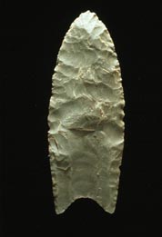
Clovis points are the characteristically fluted projectile points associated with the New World Clovis culture, a prehistoric Paleo-American culture. They are present in dense concentrations across much of North America and they are largely restricted to the north of South America. There are slight differences in points found in the Eastern United States bringing them to sometimes be called "Clovis-like". Clovis points date to the Early Paleoindian period, with all known points dating from roughly 13,400–12,700 years ago. As an example, Clovis remains at the Murry Springs Site date to around 12,900 calendar years ago. Clovis fluted points are named after the city of Clovis, New Mexico, where examples were first found in 1929 by Ridgely Whiteman.
Clovis culture is a prehistoric Paleoamerican archaeological culture, named for distinct stone and bone tools found in close association with Pleistocene fauna, particularly two Columbian mammoths, at Blackwater Locality No. 1 near Clovis, New Mexico, in 1936 and 1937, though Paleoindian artifacts had been found at the site since the 1920s. It existed from roughly 11,500 to 10,800 BCE near the end of the Last Glacial Period.
Before Present (BP) years, also known as "time before present" or "years before present (YBP)", is a time scale used mainly in archaeology, geology, and other scientific disciplines to specify when events occurred relative to the origin of practical radiocarbon dating in the 1950s. Because the "present" time changes, standard practice is to use 1 January 1950 as the commencement date (epoch) of the age scale. The abbreviation "BP" has been interpreted retrospectively as "Before Physics", which refers to the time before nuclear weapons testing artificially altered the proportion of the carbon isotopes in the atmosphere, which scientists must now account for.

Monte Verde is a Paleolithic archaeological site in the Llanquihue Province in southern Chile, located near Puerto Montt, Los Lagos Region. It contains two separate layers, the younger Monte Verde II, dating to 14,500 cal BP, and an older, much more controversial layer suggested to date to 18,500 cal BP. The Monte Verde II site has been considered key evidence showing that the human settlement of the Americas pre-dates the Clovis culture by roughly 1,000 years. This contradicts the previously accepted "Clovis first" model which holds that settlement of the Americas began after 13,500 cal BP. The Monte Verde findings were initially dismissed by most of the scientific community, but the evidence then became more accepted in archaeological circles.

Tlapacoya is an important archaeological site in Mexico, located at the foot of the Tlapacoya volcano, southeast of Mexico City, on the former shore of Lake Chalco. Tlapacoya was a major site for the Tlatilco culture.
The Big Eddy Site (23CE426) is an archaeological site located in Cedar County, Missouri, which was first excavated in 1997 and is now threatened due to erosion by the Sac River.

Hueyatlaco is an archeological site in the Valsequillo Basin near the city of Puebla, Mexico. After excavations in the 1960s, the site became notorious due to geochronologists' analyses, which have found wildly contradictory estimates for human habitation at Hueyatlaco dating from 370,000 to ca. 25,000 years before the present.

The Tepexpan Man is a Pre-Columbian-era skeleton, discovered by archaeologist Helmut de Terra in February 1947, on the shores of the former Lake Texcoco in central Mexico. The skeleton was found near mammoth remains and thought to be at least 10,000 years old. It was fancifully hailed by Time magazine as the oldest Mexican. The skeleton was found lying face down with the arms under the chest and the legs drawn up to the stomach. The body most likely sank into the mud surrounding it, leaving the shoulder, back, and hips exposed, which might explain why those elements are missing. It is possible that the body was originally deposited in the lake.
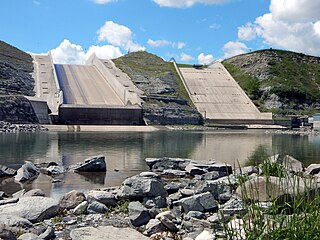
St. Mary Reservoir is a reservoir in southwestern Alberta, Canada. It was created for irrigation purposes by the damming of the St. Mary River, which was completed in 1951. The Kainai Nation's Blood 148 Indian reserve borders its northwest side. There are camping and picnic areas at the reservoir, and it is a popular site for power boating, water skiing, windsurfing, swimming and fishing.

Border Cave is an archaeological site located in the western Lebombo Mountains in Kwazulu-Natal. The rock shelter has one of the longest archaeological records in southern Africa, which spans from the Middle Stone Age to the Iron Age.

Lake Tauca is a former lake in the Altiplano of Bolivia. It is also known as Lake Pocoyu for its constituent lakes: Lake Poopó, Salar de Coipasa and Salar de Uyuni. The lake covered large parts of the southern Altiplano between the Eastern Cordillera and the Western Cordillera, covering an estimated 48,000 to 80,000 square kilometres of the basins of present-day Lake Poopó and the Salars of Uyuni, Coipasa and adjacent basins. Water levels varied, possibly reaching 3,800 metres (12,500 ft) in altitude. The lake was saline. The lake received water from Lake Titicaca, but whether this contributed most of Tauca's water or only a small amount is controversial; the quantity was sufficient to influence the local climate and depress the underlying terrain with its weight. Diatoms, plants and animals developed in the lake, sometimes forming reef knolls.
Fueguino is a volcanic field in Chile. The southernmost volcano in the Andes, it lies on Tierra del Fuego's Cook Island and also extends over nearby Londonderry Island. The field is formed by lava domes, pyroclastic cones, and a crater lake.

The peopling of the Americas began when Paleolithic hunter-gatherers (Paleo-Indians) entered North America from the North Asian Mammoth steppe via the Beringia land bridge, which had formed between northeastern Siberia and western Alaska due to the lowering of sea level during the Last Glacial Maximum. These populations expanded south of the Laurentide Ice Sheet and spread rapidly southward, occupying both North and South America, by 12,000 to 14,000 years ago. The earliest populations in the Americas, before roughly 10,000 years ago, are known as Paleo-Indians. Indigenous peoples of the Americas have been linked to Siberian populations by linguistic factors, the distribution of blood types, and in genetic composition as reflected by molecular data, such as DNA.

The Uluzzian Culture is a transitional archaeological culture between the Middle paleolithic and the Upper Paleolithic, found in Italy and Greece.

Mount Berlin is a glacier-covered volcano in Marie Byrd Land, Antarctica, 100 kilometres (62 mi) from the Amundsen Sea. It is a roughly 20-kilometre-wide (12 mi) mountain with parasitic vents that consists of two coalesced volcanoes: Berlin proper with the 2-kilometre-wide (1.2 mi) Berlin Crater and Merrem Peak with a 2.5-by-1-kilometre-wide crater, 3.5 kilometres (2.2 mi) away from Berlin. The summit of the volcano is 3,478 metres (11,411 ft) above sea level. It has a volume of 200 cubic kilometres (48 cu mi) and rises from the West Antarctic Ice Sheet. It is part of the Marie Byrd Land Volcanic Province. Trachyte is the dominant volcanic rock and occurs in the form of lava flows and pyroclastic rocks.

The history of Southern Africa has been divided into its prehistory, its ancient history, the major polities flourishing, the colonial period, and the post-colonial period, in which the current nations were formed. Southern Africa is bordered by Central Africa, East Africa, the Atlantic Ocean, the Indian Ocean, and the Sahara Desert. Colonial boundaries are reflected in the modern boundaries between contemporary Southern African states, cutting across ethnic and cultural lines, often dividing single ethnic groups between two or more states.

Kara-Bom is an Initial Upper Paleolithic archaeological site dating to 46,620 +/-1,750 cal years before present (BP), and located in Southern Siberia. It is among the earliest (probable) modern human sites for Siberia, together with Kara-Tenesh, Kandabaevo, and Podzvonskaya.
References
- 1 2 Mark, Darren F.; Gonzalez, Silvia; Huddart, David; Böhnel, Harald (May 2010). "Dating of the Valsequillo volcanic deposits: resolution of an ongoing archaeological controversy in Central Mexico". Journal of Human Evolution. 58 (5): 441–5. doi:10.1016/j.jhevol.2010.02.009. PMID 20363014.
- ↑ González, Silvia; Huddart, David; Bennett, Matthew R.; González-Huesca, Alberto (February 2006). "Human footprints in Central Mexico older than 40,000 years". Quaternary Science Reviews. 25 (3–4): 201–222. doi:10.1016/j.quascirev.2005.10.004.
- ↑ Renne, Paul R.; Feinberg, Joshua M.; Waters, Michael R.; Arroyo-Cabrales, Joaquin; Ochoa-Castillo, Patricia; Perez-Campa, Mario; Knight, Kim B. (1 December 2005). "Age of Mexican ash with alleged 'footprints'". Nature. 438 (7068): E7–E8. doi:10.1038/nature04425. PMID 16319838.
- ↑ Rose, James (February 2006). "Editorial". Quaternary Science Reviews. 25 (3–4): 199–200. doi:10.1016/j.quascirev.2006.01.005.
- ↑ "Oldest American footprints". Radio National. 8 February 2006.
- ↑ Morse, Sarita Amy; Bennett, Matthew R.; Gonzalez, Silvia; Huddart, David (September 2010). "Techniques for verifying human footprints: reappraisal of pre-Clovis footprints in Central Mexico". Quaternary Science Reviews. 29 (19–20): 2571–2578. doi:10.1016/j.quascirev.2010.03.012.
- ↑ Walker, Adele (23 July 2010). "Footprint evidence for early occupation of the Americas Refuted". Natural Environment Research Council.