Mount Kyllini or Mount Cyllene, is a mountain on the Peloponnese in Greece famous for its association with the god Hermes. It rises to 2,376 m (7,795 ft) above sea level, making it the second highest point on the peninsula. It is located near the border between the historic regions of Arcadia and Achaea—in the northeast of Arcadia, and entirely within modern Corinthia. It is located west of Corinth, northwest of Stymfalia, north of Tripoli, and south of Derveni.

Argolis or the Argolid is one of the regional units of Greece. It is part of the region of Peloponnese, situated in the eastern part of the Peloponnese peninsula and part of the tripoint area of Argolis, Arcadia and Corinthia. Much of the territory of this region is situated in the Argolid Peninsula.

Akrata, is a town and a former municipality in Achaea, West Greece, Greece. Since the 2011 local government reform it is part of the municipality Aigialeia, of which it is a municipal unit. The municipal unit has an area of 180.169 km2. Akrata is located on the right bank of the river Krathis, 3 km from its outflow into the Gulf of Corinth. The Greek National Road 8A/E65 and the railway from Patras to Corinth pass through the municipal unit, northeast of the town. The nearest town is Aigeira, 4 km to the east. It is 23 km southeast of Aigio, 52 km east of Patras and 23 km northeast of Kalavryta.

Drama is one of the regional units of Greece. It is part of the Region of East Macedonia and Thrace. Its capital is the town of Drama. The regional unit is the northernmost within the geographical region of Macedonia and the westernmost in the administrative region of East Macedonia and Thrace. The northern border with Bulgaria is formed by the Rhodope Mountains.

Agios Stefanos is a suburb in Athens, Greece. Since the 2011 local government reform it is part of the municipality Dionysos, of which it is the seat and a municipal unit. The municipal unit has an area of 8.136 km2.

Grevena is one of the regional units of Greece. It is part of the region of West Macedonia. Its capital is the town of Grevena.

Kozani is one of the regional units of Greece. It is part of the region of West Macedonia. Its capital is the city of Kozani.

Preveza is one of the regional units of Greece. It is part of the Epirus region. Its capital is the town of Preveza.
Figaleia is a mountain village and a former municipality in Elis, West Greece, Greece. Since the 2011 local government reform it is part of the municipality Zacharo, of which it is a municipal unit. The municipal unit has an area of 89.175 km2. In 2011 the population was 41 for the village and 1,371 for the municipal unit. The seat of the municipality was in Nea Figaleia. Figaleia is located south of Andritsaina, west of Megalopoli, north-northwest of Kalamata, northeast of Kyparissia and southeast of Pyrgos. Figaleia is located in mountainous southern Elis. The river Neda flows through the municipal unit. The name was taken from the ancient city-state of Phigaleia, which was located near the present village.
Sarantaporo is a village and a former municipality in the Larissa regional unit, Thessaly, Greece. Since the 2011 local government reform it is part of the municipality Elassona, of which it is a municipal unit. Population 2,455 (2011). The municipal unit has an area of 150.902 km2, and the community has an area of 26.958 km2. The town is between the mountains of Kamvounia to the northwest and the Pierian Mountains to the northeast. The river Sarantaporos flows through the municipality. Sarantaporo is on the Greek National Road 3. It is located west-southwest of Katerini, northwest of Elassona and Larissa, east of Grevena and south-southeast of Kozani.
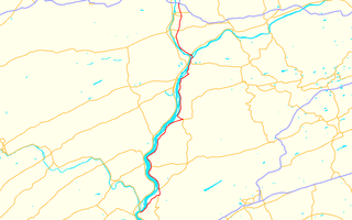
Pennsylvania Route 147 is a north–south route that runs for 58.3 miles (93.8 km) along the east shore of the Susquehanna River in central Pennsylvania, United States. The northern terminus is at an interchange with Interstate 80 and Interstate 180 in Turbot Township. The southern terminus is at an interchange with U.S. Route 22 and U.S. Route 322 in Reed Township.

Panaitoliko is a mountain range in the northeastern part of Aetolia-Acarnania and southwestern Evrytania, in western Greece. Its highest summit, Kyra Vgena, is the highest point of Aetolia-Acarnania at 1,924 m. Its length is approximately 25 km long from east to west and its width is approximately 15 km wide. The nearest mountains are Kaliakouda to the northeast, the mountains of Nafpaktia to the southeast and Valtou to the northwest. Lake Trichonida lies to the south. The Panaitoliko extends from the Acheloos valley in the northwest to the Evinos valley in the east. There are forests in the lower areas, and grasslands in the higher elevations.
Antichasia is a forested mountain range in the northern Trikala and Larissa regional units in Thessaly, Greece. The range is part of the eastern foothills of the Pindus mountains. Its highest point is 1,424 m elevation, in the eastern part of the mountains. The Meteora rocks near Kalampaka are considered part of Antichasia. Antichasia stretches from the valley of the river Mourgkani in the west to the valley of the river Titarisios in the east. Both are tributaries of the river Pineios, which flows southwest and south of the mountains. Its length is approximately 45 km from east to west. The nearest mountains ranges are Chasia to the northwest and Kamvounia to the northeast. The vast Thessalian Plain is to the south.

Vourinos is a mountain range covering the eastern Grevena and southern Kozani regional units in Greece. Its highest elevation is 1,866 metres (6,122 ft). Its length is approximately 30 km (19 mi) from northwest to southeast. It is drained by the river Aliakmonas and its tributaries. There are forests on the northern slopes and the lower areas, the higher elevations are covered with grasslands. The nearest mountain ranges are Askio to the north and Kamvounia to the southeast.
Askio is a mountain range in the northwestern part of the Kozani and the eastern part of the Kastoria regional units in northern Greece. The elevation of its highest peak, Siniatsiko, is 2,111 m (6,926 ft). There are forests in the northern part. It stretches from the village Kleisoura in the northwest to Xirolimni in the southeast, over a length of about 30 km (19 mi). The nearest mountains are the Verno to the northwest, the Vourinos to the south and the Vermio to the northeast. It is drained by tributaries of the Aliakmonas to the west and south, and towards the Lake Vegoritida to the northeast.

Verno or Vitsi is a forested mountain range in the southern part of the Florina and the northeastern part of the Kastoria regional units in northern Greece. The elevation of its highest peak, Vitsi, is 2,128 m (6,982 ft). It stretches from the village Trivouno in the northwest to Kleisoura in the southeast, over a length of about 30 km (19 mi). The nearest mountains are the Askio to the southeast, the Baba to the north and the northern Pindus to the southwest. It is drained towards the river Sakoulevas to the northeast, and towards the Aliakmonas and Lake Kastoria to the southwest.

The Muggins Mountains is a mountain range in southwest Arizona east of Yuma, Arizona, northeast of the Gila Mountains, and east of the Laguna Mountains. The Castle Dome Mountains lie to the northeast across the broad Castle Dome Plain. The Muggins Mountains Wilderness occupies the southwest portion of the range.

The Buckskin Mountains, of Arizona, are a mountain range in west-central Arizona, USA. The range lies just east of the north-south Colorado River, and borders south of the east-west, west-flowing Bill Williams River.

The 5,080-acre (20.6 km2) Coyote Mountains Wilderness of Arizona is part of the Coyote Mountains of southern Arizona in the center of Pima County. The wilderness lies about 40 mi southwest of Tucson, in the northwest of the Altar Valley. Kitt Peak is 4 mi WSW.