The United States Board on Geographic Names (BGN) is a federal body operating under the United States Secretary of the Interior. The purpose of the board is to establish and maintain uniform usage of geographic names throughout the federal government of the United States. Nevertheless, its rulings and policies have been controversial from time to time.
BGN/PCGN romanization are the systems for romanization and Roman-script spelling conventions adopted by the United States Board on Geographic Names (BGN) and the Permanent Committee on Geographical Names for British Official Use (PCGN).
Haianari Creek is a west bank tributary of the Demerara River in Upper Demerara-Berbice, Guyana. It enters the Demerara River 90 miles upstream of the Demerara's mouth.
Murrays Fall is a waterfall on the Essequibo River, Guyana, approximately 55 km south of the confluence with the Rupununi River.
The BGN/PCGN romanization system for Belarusian is a method for romanization of Cyrillic Belarusian texts, that is, their transliteration into the Latin alphabet.
Banka Cheema, is a village and Union Council of Wazirabad Tehsil, Gujranwala District, in Pakistan's Punjab province. A post office is functional in Banka Cheema by Pakistan Post under Government of Pakistan. For education in the village a Government Primary School Banka Cheema, Government Girls High School (GGHS) Banka Cheema is functional by Government of Punjab, Pakistan under Board of Intermediate and Secondary Education, Gujranwala. The only way to reach Banka Cheema is by road. 97% population of the town is Muslim.
Mendi-Munihu District is a district of the Southern Highlands Province of Papua New Guinea. Its capital is Mendi. The population was 144,629 at the 2011 census.
Vunakapeake is a village located on the north coast of the Gazelle Peninsula on the island of New Britain, East New Britain Province, Papua New Guinea. The village lies to the east of Lassul Bay and to the west of Ataliklikun Bay.
Maremgi, also known as Dineor, is a Papuan language of Indonesia. It is spoken near the village of Bonggo, west of Jayapura, in a place also known as Maremgi.
Jdeidat Yabous, previously known as Ainkania, is a village situated 45 kilometres (28 mi) west of Damascus, Syria. According to the Syria Central Bureau of Statistics, the village had a population of 994 in the 2004 census.
Kafr Hawr is a Syrian village situated 35 kilometres (22 mi) southwest of Damascus. According to the Syria Central Bureau of Statistics, the village had a population of 2,957 at the 2004 census.

Cape Espiritu Santo, also known as Cape Espiritu Santo Mountains, is the northeastern point of the Northern Samar and the northernmost point of Samar Island. It was named Cabo Espiritu Santo by early European explorers, since it was discovered on the Feast of the Holy Spirit. It is also the first land sighted by the Spaniards when sailing from Nueva España, marks the end of their long sailing as they approaches the land and coast of the Ibabaw in the Philippines. Spanish navigators noted the mountains' value as they are visible 40 miles out to sea. There are two prominent summits in this location. One rises 1,481 ft (451.41 m) and the other 1,457 ft (444.09 m).
Baudisson Island is an island of Papua New Guinea, located south of New Hanover Island and west of the northern part of New Ireland. It is located between Selapiu Island and Manne Island. There is a plantation on the island.
Big Ndrova Island, sometimes called simply Ndrova Island, is an island of Manus Province, Papua New Guinea, one of the Admiralty Islands. It is off the southern coast of Manus Island.
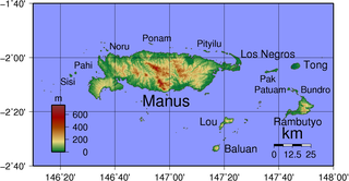
Pak Island is an island of Papua New Guinea. It is in the Admiralty Islands group of the Bismarck Archipelago.
Little Ndrova Island, also called Ndawara Islet, is an island of Manus Province, Papua New Guinea, one of the Admiralty Islands.
La Quebradona is a river located in Ocotepeque Department, Honduras.
Cambamba is a village, as well as the name of a commune in Angola. It is situated in the Uíge Province.

Yirowe, also spelt Yerrowa, Yerowa, Yeroweh or Yerowah is a town in the Burao District, located in the Togdheer region of Somaliland. The town is located 20 km east of Burao, the provincial capital of the Togdheer region.