Location
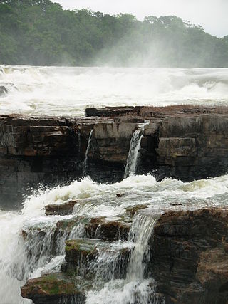
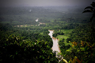
Xingu State Park is in the municipality of Santa Cruz do Xingu and has an area of 96,288 hectares (237,930 acres). The park is in the Xingu River basin. It includes a section of the Xingu River that was outside the Xingu Indigenous Park. The park is important in helping protect the 2,600,000 hectares (6,400,000 acres) Xingu Indigenous Park, inhabited by fourteen ethnic groups, which is now surrounded by agricultural developments.
The park is to the south of the Menkragnoti Indigenous Territory, which is on the other side of the Xingu River. It adjoins the Capoto/Jarina Indigenous Territory to the west. Its boundary to the north is the border with the state of Pará. To the east the Fontourinha stream defines its boundary. The park is in the Amazon biome. 81.87% of the park is covered by savanna/pioneer contact, and 18% by savanna/rainforest contact.
Conservation
Xingu State Park was created by decree 3.585 of 7 December 2001 with an area of about 134,463 hectares (332,270 acres). It was redefined by law 8054 of 29 December 2003, signed by the state governor Blairo Maggi, which reduced its size to 95,024 hectares (234,810 acres). The reduction was justified on the basis of a referendum of the people of Santa Cruz do Xingu by technicians from the State Environmental Foundation (FEMA). The agricultural frontier was limited by the amount of protected land, some of which had to be released for expansion of food production.
The consultative council was established on 28 September 2007. The objectives are to protect and conserve the various ecosystems and to prevent human actions that would jeopardise the future of the many indigenous groups found in the park. The conservation unit is supported by the Amazon Region Protected Areas Program.

The Serra do Pardo National Park is a National park in the state of Pará, Brazil.

Anavilhanas National Park is a national park that encompasses a huge river archipelago in the Rio Negro in the state of Amazonas, Brazil. It is part of a World Heritage Site.
Juruena National Park, declared in 2006, is the third largest national park of Brazil. It is located along the Juruena River, in the north of Mato Grosso state and the south of Amazonas state. It forms part of a corridor of protected areas that is meant to contain agricultural expansion into the Amazon rainforest.
Rio Ronuro Ecological Station is an ecological station in the state of Mato Grosso, Brazil. It protects an area of contact between Amazon rainforest in the north and Cerrado semi-deciduous forest in the south. Since being created in 1998 it has been reduced in size and has suffered from significant deforestation.

Rio Novo National Park is a national park in the state of Pará, Brazil.
Nascentes do Lago Jari National Park is a national park in the state of Amazonas, Brazil. It protects an area of Amazon rainforest in the BR-319 highway area of influence.

The Campos Amazônicos National Park is a National park in the states of Rondônia, Amazonas and Mato Grosso, Brazil.
The Chandless State Park is a state park in the state of Acre, Brazil. It protects an important but relatively unexplored region of rainforest with bamboos holding great biodiversity. It is valuable as an ecological corridor between adjoining conservation units and indigenous territories. Some parts of the park are used by uncontacted nomadic indigenous people.
Rio Negro State Park South Section is a State park in the state of Amazonas, Brazil. It protects an area of Amazon rainforest to the east of the Rio Negro that is home to the endangered pied tamarin. The area was reduced in 2001 and was further reduced in 2014 to create a sustainable development reserve for the people that had been living there since before the park was created.
The Rio Negro State Park North Section is a state park in the state of Amazonas, Brazil. It protects an area of Amazon rainforest to the west of the Rio Negro.
Sucunduri State Park is a state park in the state of Amazonas, Brazil.
The Igarapés do Juruena State Park is a state park in the state of Mato Grosso, Brazil.
The Guariba State Park is a State park in the state of Amazonas, Brazil.
The Guajará-Mirim State Park is a state park in the state of Rondônia, Brazil. It protects an area of savanna forest and transition into rainforest. It is in an area where there is great pressure from loggers and ranchers. A road was illegally cut through the park, apparently by loggers supported by local politicians. This received federal approval after the fact, since it provides access to areas otherwise cut off by flooding of the Madeira River.
The Serra dos Reis State Park is a state park in the state of Rondônia, Brazil.
Matupiri State Park is a state park in the state of Amazonas, Brazil. It protects a rich area of Amazon rainforest and an ecologically important area of woodland savanna along the Matupiri River. Unusually for a state park, it includes an "indigenous special use zone" that allows the Mura people to continue to fish and extract forest products, as they have for many generations.
The Corumbiara State Park is a state park in the state of Rondônia, Brazil.
The Cantão State Park is a state park in the state of Tocantins, Brazil. It protects the Cantão wetlands, an area of igapó flooded forest in the ecotone where the Amazon rainforest merges into the cerrado.

The Cristalino State Park is a state park in the state of Mato Grosso, Brazil.
The Serra Ricardo Franco State Park is a state park in the state of Mato Grosso, Brazil. It protects the edge of a plateau on the border with Bolivia in the region of transition from cerrado to Amazon rainforest. The park has been poorly protected and is badly degraded in areas by deforestation and conversion to pasturage. It is threatened by illegal squatters, hunting and burning.
This page is based on this
Wikipedia article Text is available under the
CC BY-SA 4.0 license; additional terms may apply.
Images, videos and audio are available under their respective licenses.
