
Azerbaijan, officially the Republic of Azerbaijan, is a transcontinental country located at the boundary of Eastern Europe and West Asia. It is a part of the South Caucasus region and is bounded by the Caspian Sea to the east, Russia to the north, Georgia to the northwest, Armenia and Turkey to the west, and Iran to the south. Baku is the capital and largest city.

Nagorno-Karabakh, also referred to as Artsakh by Armenians, is a landlocked region in the South Caucasus, within the mountainous range of Karabakh, lying between Lower Karabakh and Syunik, and covering the southeastern range of the Lesser Caucasus mountains. The region is mostly mountainous and forested.

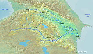
The Aras is a river in the Caucasus. It rises in eastern Turkey and flows along the borders between Turkey and Armenia, between Turkey and the Nakhchivan exclave of Azerbaijan, between Iran and both Azerbaijan and Armenia, and, finally, through Azerbaijan where it flows into the Kura river. It drains the south side of the Lesser Caucasus Mountains while the Kura drains the north side of the Lesser Caucasus. The river's total length is 1,072 km (666 mi) and its watershed covers an area of 102,000 km2 (39,000 sq mi). The Aras is one of the longest rivers in the Caucasus.

Azerbaijanis, Azeris, or Azerbaijani Turks are a Turkic ethnic group living mainly in the Azerbaijan region of northwestern Iran and the Republic of Azerbaijan. They are predominantly Shia Muslims. They comprise the largest ethnic group in the Republic of Azerbaijan and the second-largest ethnic group in neighboring Iran and Georgia. They speak the Azerbaijani language, belonging to the Oghuz branch of the Turkic languages.
Arran, also known as Aran, was a geographical name used in ancient and medieval times to signify a historically-Iranian region which lay within the triangle of land, lowland in the east and mountainous in the west, formed by the junction of the Kura and Aras rivers, including the highland and lowland Karabakh, Mil plain and parts of the Mughan plain. In pre-Islamic times, it corresponded roughly to the territory of the modern-day Republic of Azerbaijan. The term is the Middle Persian equivalent to the Greco-Roman Albania. It was known as Aghvania, Alvan-k in Armenian, and Al-ran in Arabic.

Artsakh, officially the Republic of Artsakh or the Nagorno-Karabakh Republic, is a breakaway state in the South Caucasus whose territory is internationally recognised as part of Azerbaijan. Artsakh controls a part of the former Nagorno-Karabakh Autonomous Oblast, including the capital of Stepanakert. It is an enclave within Azerbaijan. Its only overland access route to Armenia is via the 5 km (3.1 mi) wide Lachin corridor. The corridor was under the control of Russian peacekeepers between 2020 and 2022 until Azerbaijan launched a blockade of the region and installed a military checkpoint.
A raion is a type of administrative unit of several post-Soviet states. The term is used for both a type of subnational entity and a division of a city. The word is from the French rayon, and is commonly translated as "district" in English.

Zangilan is a city in Azerbaijan and the administrative centre of the Zangilan District. It is situated along the Voghji (Okhchuchay) river.

The administrative divisions of the Republic of Artsakh are of two types; provinces and cities. There are six provinces and one special administrative city - the capital of the Republic.
Sheylanli is a village in the Lachin District of Azerbaijan. Historically, the village had a Kurdish population; the town itself is named after the Kurdish Sheylanli tribe. Sheylanli is surrounded by several historical, cultural and architectural monuments, including an arch bridge on the Hakari River.
The following outline is provided as an overview of and topical guide to Azerbaijan:

Charektar is a village de facto in the Shahumyan Province of the breakaway Republic of Artsakh, de jure in the Kalbajar District of Azerbaijan, in the disputed region of Nagorno-Karabakh. The village had an Azerbaijani-majority population prior to their exodus during the First Nagorno-Karabakh War.
Qarağac is a village in the Qubadli District of Azerbaijan.
Xaçındərbətli is a village in the Agdam District of Azerbaijan.
Imar or Karamli is a village that is, de facto, in the Martakert Province of the breakaway Republic of Artsakh; de jure, it is in the Kalbajar District of Azerbaijan, in the disputed region of Nagorno-Karabakh. The village had an Azerbaijani-majority population prior to their expulsion during the Nagorno-Karabakh war.
Zağalar is a village in the Kalbajar District of Azerbaijan.


