The Wilsons Promontory National Park, commonly known as Wilsons Prom or The Prom, is a national park in the Gippsland region of Victoria, Australia, located approximately 157 kilometres (98 mi) southeast of Melbourne.

The Tidal River is a perennial river of the West Gippsland catchment, located in the Wilsons Promontory region of the Australian state of Victoria. A permanent camping ground, which flows past the camping ground to the north, is also called Tidal River.

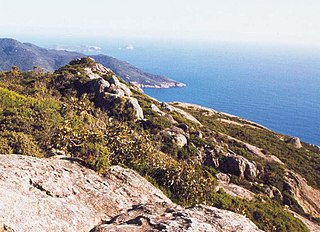
South East Point lies on the southerly tip of Wilsons Promontory, Victoria, Australia. South East Point is located at 39°07′S146°25′E. It commands sensational views of Bass Strait and is a major landmark for all ships travelling between the southern Australian ports and the Pacific Ocean. South East Point is the site of the Wilsons Promontory Lighthouse. The only access for visitors is a full day hike from the Tidal River camping ground.

The Shire of South Gippsland is a local government area in Victoria, Australia, located in the south-eastern part of the state. It covers an area of 3,305 square kilometres (1,276 sq mi) and, at the 2016 Census had a population of over 28,000.

The Division of McMillan is an Australian Electoral Division in the state of Victoria. It is located in the western part of the Gippsland region, which extends for the length of Victoria's eastern Bass Strait coastline. It includes the outer south-eastern Melbourne suburb of Pakenham, and also includes the towns of Warragul, Moe, Wonthaggi, Leongatha and Foster. It stretches from Mount Baw Baw and the Baw Baw National Park in the north to Wilsons Promontory, and the Wilsons Promontory National Park in the south. It is the southernmost Electoral Division in continental Australia.
Foster is a dairying and grazing town 174 kilometres (108 mi) south-east of Melbourne on the South Gippsland Highway in Victoria, Australia. At the 2016 census Foster had an urban population of 1,164. It is about 20 kilometres (12 mi) north of the Gippsland coastline which includes Shallow Inlet, Corner Inlet, Waratah Bay, Yanakie and Wilsons Promontory.

South Point is the southernmost point of the Australian mainland. It is at the tip of Wilsons Promontory in the state of Victoria and is part of Wilsons Promontory National Park.
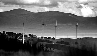
Toora wind farm is a wind power station at Toora in South Gippsland, Victoria, Australia. It is located north of Wilsons Promontory and 150 km SE of Melbourne. The wind farm is on a ridge overlooking the small town of Toora.

The County of Buln Buln is one of the 37 counties of Victoria which are part of the cadastral divisions of Australia, used for land titles. It was first proclaimed in government gazette on 24 Feb 1871 together with others from the Gipps Land District. It includes Wilsons Promontory, and the Victorian coast from around Venus Bay in the west to Lake Wellington in the east. Sale is near its north-eastern edge. Some time earlier maps showed proposed counties of Bass, Douro, and part of Haddington and Bruce occupying the area of Buln Buln.

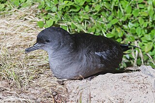
Curtis Island is a granite island, with an area of 150 ha, in south-eastern Australia. It is part of Tasmania’s Curtis Group, lying in northern Bass Strait between the Furneaux Group and Wilsons Promontory in Victoria. It is a nature reserve and has been identified as an Important Bird Area because it supports up to 390,000 breeding pairs of short-tailed shearwaters or Tasmanian muttonbirds.
Cone Islet is a small granite island, with an area of 4.82 ha, in south-eastern Australia. It is part of Tasmania’s Curtis Group, lying in northern Bass Strait between the Furneaux Group and Wilsons Promontory in Victoria.
Sugarloaf Rock is a small granite island, with an area of 1.07 ha, in south-eastern Australia. It is part of Tasmania’s Curtis Group, lying in northern Bass Strait between the Furneaux Group and Wilsons Promontory in Victoria.
Yanakie is a small, coastal township and district on the Yanakie Isthmus in South Gippsland, in the state of Victoria, south-eastern Australia.
Shallow Inlet is a marine inlet, opening onto Waratah Bay on the western side of the Yanakie Isthmus in South Gippsland, Victoria, south-eastern Australia. It lies close to the small holiday communities of Sandy Point and Yanakie, as well as to Wilsons Promontory and the Wilsons Promontory National Park.
The Wilsons Promontory Islands Important Bird Area comprises a loose cluster of 19 small, granite islands, with a collective area of 658 ha, scattered around Wilsons Promontory in the state of Victoria, south-eastern Australia. The three southernmost islands are part of the state of Tasmania. They are important for their breeding seabirds.
Tidal River is a locality in Wilsons Promontory National Park, Wilsons Promontory, Victoria, Australia. It contains the main park administration and service centres as well as a permanent camping ground that takes its name from the Tidal River, which flows past the camping ground to the north.
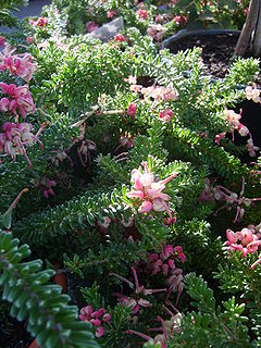
Grevillea lanigera 'Mt Tamboritha' is a cultivar of the genus Grevillea, planted widely in Australia and other countries for its ornamental foliage and flowers. It is the most popular form of Grevillea lanigera in cultivation. It is also known by the names 'Mt Tamboritha form', 'Compacta', 'Prostrate', 'Prostrate Form' or the misnomer 'Mt Tambourine'.