
San Pablo Bay is a tidal estuary that forms the northern extension of San Francisco Bay in the East Bay and North Bay regions of the San Francisco Bay Area in northern California.

The Santa Margarita River which with the addition of what is now Temecula Creek, was formerly known as the Temecula River, is a short intermittent river on the Pacific coast of southern California in the United States, approximately 30.9 miles (49.7 km) long. One of the last free-flowing rivers in southern California, it drains an arid region at the southern end of the Santa Ana Mountains, in the Peninsular Ranges between Los Angeles and San Diego.
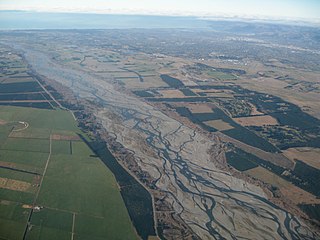
An alluvial plain is a largely flat landform created by the deposition of sediment over a long period of time by one or more rivers coming from highland regions, from which alluvial soil forms. A floodplain is part of the process, being the smaller area over which the rivers flood at a particular period of time, whereas the alluvial plain is the larger area representing the region over which the floodplains have shifted over geological time.

The Fraser Canyon is a major landform of the Fraser River where it descends rapidly through narrow rock gorges in the Coast Mountains en route from the Interior Plateau of British Columbia to the Fraser Valley. Colloquially, the term "Fraser Canyon" is often used to include the Thompson Canyon from Lytton to Ashcroft, since they form the same highway route which most people are familiar with, although it is actually reckoned to begin above Williams Lake, British Columbia at Soda Creek Canyon near the town of the same name.

Lujiazui, formerly known as Lokatse from its pronunciation in Shanghainese, is a locality in Shanghai, a peninsula formed by a bend in the Huangpu River. Since the early 1990s, Lujiazui has been developed specifically as a new financial district of Shanghai. The decision to earmark Lujiazui for this purpose reflects its location: it is located on the east side of the Huangpu River in Pudong, and sits directly across the river from the old financial and business district of the Bund.

The Camelsfoot Range is a sub-range of the Chilcotin Ranges subdivision of the Pacific Ranges of the Coast Mountains in British Columbia. The Fraser River forms its eastern boundary. The range is approximately 90 km at its maximum length and less than 30 km wide at its widest.

The Cayoosh Gold Rush was one of several in the history of the region surrounding Lillooet, British Columbia, Canada. If estimates of its yield are true, it would be one of the richest single finds in the gold mining history of that province.
Emory Creek Provincial Park is a provincial park in British Columbia, Canada, located on the west side of the Fraser River just south of the town of Yale. It commemorates the location of a large boomtown, variously known as Emory, Emory Bar or Emory City, that first rose during the Fraser Canyon Gold Rush but became a major construction town during the building of the Canadian Pacific Railway in the 1880s.
Emory Creek in 1858 was a tent and shack camp, established by miners in search of gold. When it became evident that the gold was not available in the amounts estimated, the miners started moving north on the Fraser River. A few Chinese remained in the area. The area came into the hands of a man named Walker, who felt Emory Creek would become the head of riverboat navigation on the Fraser. Eventually, he sold the land to the Oppenheimer Brothers in early 1879. In the fall of 1879, Emory was chosen by the C.P.R. as the western terminus. In a short time it became Emory Creek. The town consisted of thirteen streets with its own newspaper, various shops, a brewery, nine saloons and a sawmill. When Yale was made the terminus, Emory was all but abandoned by 1885, with the completion of the railway. Today, it is an easily accessible treed campground with paved roads and flush outhouses.

The Fresno River is a river in Central California and a major tributary of the San Joaquin River. It runs approximately 68 miles (109 km) from the Sierra Nevada Range to the San Joaquin River. Although called the 'Fresno' River, it is one of the largest and longest river systems in Madera County.

The Saltoro Mountains are a subrange of the Karakoram Range. They are located in the southeast Karakoram on the southwest side of the Siachen Glacier, one of the two longest glaciers outside the polar regions. The name given to this range is shared with the Saltoro Valley which is located to the west of this range, downslope on the Pakistan side of the Saltoro Range which generally follows the Actual Ground Position Line. Saltoro Kangri peak, Saltoro River, and Saltoro Valley are features on this range. The Actual Ground Position Line (AGPL) between Indian and Pakistan held area runs through this range, where the high peaks and passes of the Siachen area are held by India, whereas Pakistan occupies the lower peaks and valleys to the west.

The Palmer River is a river located in Far North Queensland, Australia. The area surrounding the river was the site of a gold rush in the late 19th century which started in 1873.

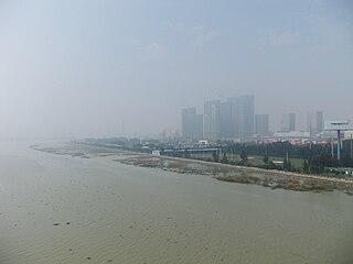
Wusong, formerly romanized as Woosung, is a subdistrict of Baoshan in northern Shanghai. Prior to the city's expansion, it was a separate port town located 14 miles (23 km) down the Huangpu River from Shanghai's urban core.
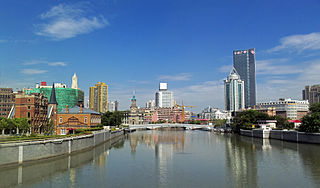
Suzhou Creek, also called the Wusong (Woosung) River, is a river that passes through the Shanghai city center. It is named after the neighboring city of Suzhou (Soochow), Jiangsu, the predominant settlement in this area prior to the rise of Shanghai as a metropolis.

Xindian District is an inner city district in the southern part of New Taipei City, Taiwan.
The Jin River, also known by its Chinese name Jin Jiang, is located in southern Fujian. Its basin includes most of Quanzhou prefecture-level city, whose Jinjiang County is named after it.
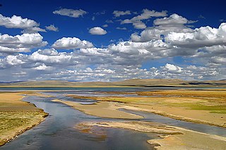
The Mar Qu, Ulan Moron or Tuotuo River is a 336 km (209 mi) long river, located in Qinghai province in the People's Republic of China. Although the Dangqu is the geographic source of the Yangtze River, the Ulan Moron has been traditionally regarded as the main river. With its location in Inner Asia, it therefore belongs to the East China Sea watershed basin.
The Mulan River or Creek is a river in Fujian, China, which drains into Xinghua Bay on the Taiwan Strait between the East and South China Seas. It is the largest river in Central Fujian.

The Cao'e River is one of the largest rivers in Zhejiang Province of East China, named after Cao E, a Han dynasty girl venerated for her filial piety. Its main source is in Pan'an County in the Dapan Mountains, and the river empties into the Hangzhou Bay near the Qiantang River estuary. It has a total length of 182.4 kilometres (113.3 mi), and a basin area of 5,930.9 square kilometres (2,289.9 sq mi).

The Hells Canyon Massacre was a massacre where thirty-four Chinese goldminers were ambushed and murdered in May 1887. In 2005, the area was renamed Chinese Massacre Cove, and a memorial was placed there in 2012 in three languages, Chinese, English, and Nez Perce.