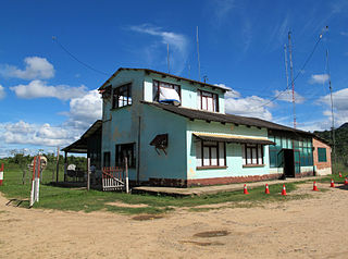
Yapacaní Airport

Last updated
Yapacaní Airport
Summary
Airport type Public
Serves Yapacaní
Elevation  AMSL 816 ft / 249 m
Coordinates 17°00′35″S64°03′35″W / 17.00972°S 64.05972°W / -17.00972; -64.05972 (Yapacaní Airport (Yapacaní)) Coordinates: 17°00′35″S64°03′35″W / 17.00972°S 64.05972°W / -17.00972; -64.05972 (Yapacaní Airport (Yapacaní))
Map
Bolivia adm location map.svg
Airplane silhouette.svg
SLYI
Location of Yapacaní Airport in Bolivia
Runways
Direction Length Surface
ft m
16/34 1,286 Grass
Source: GCM [1] Landings.com [2] Google Maps [3]

Yapacaní Airport( ICAO : SLYI) is an airport serving the town of Yapacaní in the Santa Cruz Department of Bolivia. The airport is by the village of Los Pozos, [4] 47 kilometres (29 mi) north of Yapacaní.

ICAO airport code four-letter code designating many airports around the world

The ICAOairport code or location indicator is a four-letter code designating aerodromes around the world. These codes, as defined by the International Civil Aviation Organization and published in ICAO Document 7910: Location Indicators, are used by air traffic control and airline operations such as flight planning.

Yapacaní Town in Santa Cruz Department, Bolivia

Yapacaní is the largest town in the province of Ichilo in the Bolivian department of Santa Cruz. It lies on the west bank of the Yapacani River, at the mouth of the Surutú River, 100 km north-west of Santa Cruz de la Sierra, the largest city in Bolivia. It is the centre of the district of Yapacaní Municipio. Prior to its foundation on 23 August 1953, there was a military post called El Comando.

Bolivia country in South America

Bolivia, officially the Plurinational State of Bolivia is a landlocked country located in western-central South America. The capital is Sucre while the seat of government and financial center is located in La Paz. The largest city and principal industrial center is Santa Cruz de la Sierra, located on the Llanos Orientales a mostly flat region in the east of Bolivia.

Contents

See also

Transport in Bolivia is mostly by road. The railways were historically important in Bolivia, but now play a relatively small part in the country's transport system. Because of the country's geography, aviation is also important.

Related Research Articles

Jorge Wilstermann International Airport

Jorge Wilstermann International Airport is a high elevation international airport serving Cochabamba, the capital of the Cochabamba Department of Bolivia. The facility is named in honor of Jorge Wilstermann, an early Bolivian commercial aviator.

Captain Aníbal Arab Airport

Captain Aníbal Arab Airport is an international airport serving the Acre River port city of Cobija, the capital of the Pando Department of Bolivia.

Guayaramerín Airport

Capitán de Av. Emilio Beltrán Airport is an airport serving the Mamoré River town of Guayaramerín in the Beni Department of Bolivia.

Puerto Suárez International Airport

Puerto Suárez International Airport is an airport serving Puerto Suárez, a city in the Santa Cruz Department of Bolivia. The airport is in the easternmost part of Bolivia, near the border with Brazil.

Riberalta Airport

Capitán Av. Selin Zeitun Lopez Airport is an airport serving Riberalta, a port city on the Beni River in the Beni Department of Bolivia. The airport is in the western section of the city, near the confluence of the Beni and Madre de Dios Rivers.

Rurrenabaque Airport

Rurrenabaque Airport is an airport serving Rurrenabaque, a port city on the Beni River in the Beni Department of Bolivia. The airport is 2 kilometres (1.2 mi) northeast of the city.

Capitán Germán Quiroga Guardia Airport

Capitán Germán Quiroga Guardia Airport is an airport serving San Borja, a town in the Beni Department of Bolivia. The runway is in the eastern side of the town.

Capitán Oriel Lea Plaza Airport airport

Capitán Oriel Lea Plaza Airport is an airport serving Tarija, the capital of the Tarija Department of Bolivia. The airport is in the southeastern section of the city, which is within a basin of the Cordillera Central mountain range. There is distant mountainous terrain in all quadrants.

Santa Ana del Yacuma Airport

Santa Ana del Yacuma Airport is an airport serving the town of Santa Ana del Yacuma in the Beni Department of Bolivia. The runway is just south of the town.

Bermejo Airport airport

Bermejo Airport is an airport serving Bermejo, a city in the Tarija Department of Bolivia.

Captain Nicolas Rojas Airport

Capitán Nicolas Rojas Airport is an extremely high elevation airport serving the city of Potosí, the capital of the Potosí Department in Bolivia.

Juan Mendoza Airport airport

Juan Mendoza Airport is an extremely high elevation airport serving the city of Oruro, the capital of the Oruro Department in Bolivia.

Lieutenant Colonel Rafael Pabón Airport

Lieutenant Colonel Rafael Pabón Airport is an airport serving the city of Villamontes in the Gran Chaco Province of the Tarija Department of Bolivia.

Monteagudo Airport

Monteagudo Airport is an airport serving Monteagudo, a town in the Chuquisaca Department of Bolivia.

Copacabana Airport

Copacabana Airport is an extremely high elevation airport serving Copacabana, a town on Lake Titicaca in the La Paz Department of Bolivia.

Chimore Airport

Chimore Airport is an airport serving Chimoré, a town in the Cochabamba Department of Bolivia.

Ixiamas Airport

Ixiamas Airport is an airport serving the town of Ixiamas in the La Paz Department of Bolivia.

Challapata Airport

Challapata Airport is a high-elevation airport serving the city of Challapata in the Oruro Department of Bolivia.

References

The Aviation Safety Network (ASN) is a website that keeps track of aviation accidents, incidents, and hijackings. Their database contains details of over 10,700 reports. The ASN includes an aviation database with aviation investigations, news, photos, and statistics.