In Greek mythology, the Amazons are portrayed in a number of ancient epic poems and legends, such as the Labours of Heracles, the Argonautica and the Iliad. They were a group of female warriors and hunters, who were as skilled and courageous as men in physical agility, strength, archery, riding skills, and the arts of combat. Their society was closed to men and they only raised their daughters and returned their sons to their fathers, with whom they would only socialize briefly in order to reproduce.
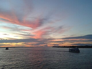
The Amazon River in South America is the largest river by discharge volume of water in the world, and the disputed longest river system in the world in comparison to the Nile.

The country of Brazil occupies roughly half of South America, bordering the Atlantic Ocean. Brazil covers a total area of 8,514,215 km2 (3,287,357 sq mi) which includes 8,456,510 km2 (3,265,080 sq mi) of land and 55,455 km2 (21,411 sq mi) of water. The highest point in Brazil is Pico da Neblina at 2,994 m (9,823 ft). Brazil is bordered by the countries of Argentina, Bolivia, Colombia, Guyana, Paraguay, Peru, Suriname, Uruguay, Venezuela, and France.
The Madeira River is a major waterway in South America. It is estimated to be 1,450 km (900 mi) in length, while the Madeira-Mamoré is estimated near 3,250 km (2,020 mi) or 3,380 km (2,100 mi) in length depending on the measuring party and their methods. The Madeira is the biggest tributary of the Amazon, accounting for about 15% of the water in the basin. A map from Emanuel Bowen in 1747, held by the David Rumsey Map Collection, refers to the Madeira by the pre-colonial, indigenous name Cuyari.
The River of Cuyari, called by the Portuguese Madeira or the Wood River, is formed by two great rivers, which join near its mouth. It was by this River, that the Nation of Topinambes passed into the River Amazon.
The Marañón River is the principal or mainstem source of the Amazon River, arising about 160 km to the northeast of Lima, Peru, and flowing northwest across plateaus 3,650 m high, it runs through a deeply eroded Andean valley, along the eastern base of the Cordillera of the Andes, as far as 5° 36′ southern latitude; from where it makes a great bend to the northeast, and cuts through the jungle Ande in its midcourse, until at the Pongo de Manseriche it flows into the flat Amazon basin. Although historically, the term "Marañon River" often was applied to the river all the way to the Atlantic Ocean, nowadays the Marañon River is generally thought to end at the confluence with the Ucayali River, after which most cartographers label the ensuing waterway the Amazon River.
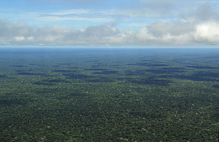
The Amazon rainforest, also called Amazon jungle or Amazonia, is a moist broadleaf tropical rainforest in the Amazon biome that covers most of the Amazon basin of South America. This basin encompasses 7,000,000 km2 (2,700,000 sq mi), of which 5,500,000 km2 (2,100,000 sq mi) are covered by the rainforest. This region includes territory belonging to nine nations and 3,344 formally acknowledged indigenous territories.
A tributary, or affluent, is a stream or river that flows into a larger stream or main stem river or a lake. A tributary does not flow directly into a sea or ocean. Tributaries and the main stem river drain the surrounding drainage basin of its surface water and groundwater, leading the water out into an ocean. The Irtysh is a chief tributary of the Ob river and is also the longest tributary river in the world with a length of 4,248 km (2,640 mi). The Madeira River is the largest tributary river by volume in the world with an average discharge of 31,200 m3/s (1.1 million cu ft/s).

Henry Walter Bates was an English naturalist and explorer who gave the first scientific account of mimicry in animals. He was most famous for his expedition to the rainforests of the Amazon with Alfred Russel Wallace, starting in 1848. Wallace returned in 1852, but lost his collection on the return voyage when his ship caught fire. When Bates arrived home in 1859 after a full eleven years, he had sent back over 14,712 species of which 8,000 were new to science. Bates wrote up his findings in his best-known work, The Naturalist on the River Amazons.

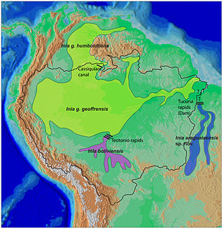
The Amazon river dolphin, also known as the boto, bufeo or pink river dolphin, is a species of toothed whale endemic to South America and is classified in the family Iniidae. Three subspecies are currently recognized: I. g. geoffrensis, I. g. boliviensis and I. g. humboldtiana while position of Araguaian river dolphin within the clade is still unclear. The three subspecies are distributed in the Amazon basin, the upper Madeira River in Bolivia, and the Orinoco basin, respectively.

Amazonas is a state of Brazil, located in the North Region in the north-western corner of the country. It is the largest Brazilian state by area and the ninth-largest country subdivision in the world. It is the largest country subdivision in South America, being greater than the areas of Chile, Paraguay, and Uruguay combined. Mostly located in the Southern Hemisphere, Amazonas is the third-largest country subdivision in the Southern Hemisphere after the Australian states of Western Australia and Queensland. Located entirely in the Western Hemisphere, it is the fourth-largest country subdivision in the Western Hemisphere after Greenland, Nunavut, and Alaska. If independent, Amazonas could become the sixteenth-largest country in the world, slightly larger than Mongolia. Neighbouring states are Roraima, Pará, Mato Grosso, Rondônia, and Acre. It also borders the nations of Peru, Colombia and Venezuela. This includes the Departments of Amazonas, Vaupés and Guainía in Colombia, as well as the Amazonas state in Venezuela, and the Loreto Region in Peru.
River dolphins are a polyphyletic group of fully aquatic mammals that reside exclusively in freshwater or brackish water. They are an informal grouping of dolphins, which itself is a paraphyletic group within the infraorder Cetacea. Extant river dolphins are placed in two superfamilies, Platanistoidea and Inioidea. They comprise the families Platanistidae, the recently extinct Lipotidae, Iniidae and Pontoporiidae. There are five extant species of river dolphins. River dolphins, alongside other cetaceans, belong to the clade Artiodactyla, with even-toed ungulates, and their closest living relatives the hippopotamuses, from which they diverged about 40 million years ago. Specific types of dolphins can be pink.

The Rio Negro, or Guainía as it is known in its upper part, is the largest left tributary of the Amazon River, the largest blackwater river in the world, and one of the world's ten largest rivers by average discharge.
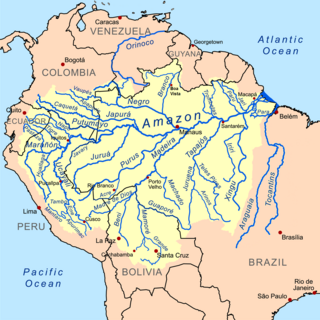
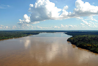
The Amazon basin is the part of South America drained by the Amazon River and its tributaries. The Amazon drainage basin covers an area of about 7,000,000 km2 (2,700,000 sq mi), or about 35.5 percent of the South American continent. It is located in the countries of Bolivia, Brazil, Colombia, Ecuador, Guyana, Peru, Suriname, and Venezuela, as well as the territory of French Guiana.

Manaus is the capital and largest city of the Brazilian state of Amazonas. It is the seventh-largest city in Brazil, with an estimated 2020 population of 2,219,580 distributed over a land area of about 11,401 km2 (4,402 sq mi). Located at the east centre of the state, the city is the centre of the Manaus metropolitan area and the largest metropolitan area in the North Region of Brazil by urban landmass. It is situated near the confluence of the Negro and Amazon rivers. It is one of the two cities in the Amazon Rainforest with a population of over 1 million people, alongside Belém.

The Tapajós is a river in Brazil. It runs through the Amazon Rainforest and is a major tributary of the Amazon River. When combined with the Juruena River, the Tapajós is approximately 2,080 km (1,290 mi) long. It is one of the largest clearwater rivers, accounting for about 6% of the water in the Amazon basin.

Loreto is Peru's northernmost department and region. Covering almost one-third of Peru's territory, Loreto is by far the nation's largest department, slightly larger than Japan; it is also one of the most sparsely populated regions due to its remote location in the Amazon Rainforest. Its capital is Iquitos.

The Japurá River or Caquetá River is a river about 2,820 kilometres (1,750 mi) long in the Amazon basin. It rises in Colombia and flows eastward through Brazil to join the Amazon River.

Amazonía region in southern Colombia comprises the departments of Amazonas, Caquetá, Guainía, Guaviare, Putumayo and Vaupés, and covers an area of 483,000 km², 35% of Colombia's total territory. The region is mostly covered by tropical rainforest, or jungle, which is a part of the greater Amazon rainforest.
Amazon most often refers to:
