Adummim is a place-name mentioned in the biblical Book of Joshua in connection with the ascent of Adummim.

Khirbat Iribbin or Khurbet 'Arubbin, was a Palestinian Arab village in the Upper Galilee, located 23 km (14 mi) northeast of the city of Acre. In 1945, it had a built-up land area of over 2,000 dunums and a population of 360 Arab Muslims.

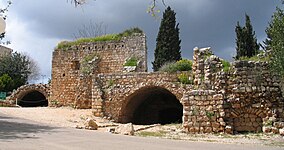
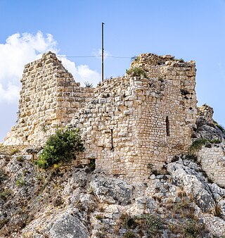
Khirbat Jiddin, known in the Kingdom of Jerusalem as Judin, was an Ottoman fortress in the western Upper Galilee, originally built by the Teutonic Order after 1220 as a crusader castle, 16 km northeast of the city of Acre, which at the time was the capital of the Kingdom of Jerusalem. The castle was destroyed by the Mamluk sultan Baibars sometime between 1268-1271 and lay in ruins until being rebuilt and expanded by the Arab ruler Zahir al-Umar as Qal'at Jiddin in the 1760s, only to be destroyed again around 1775 by Jazzar Pasha. The ruined fortress, known as Khirbat Jiddin, was later inhabited by the al-Suwaytat Bedouin tribe.

Belvoir Castle, also called Coquet by the Crusaders, also Kochav HaYarden and Kawkab al-Hawa, is a Crusader castle in northern Israel, on a hill on the eastern edge of the Issachar Plateau, on the edge of Lower Galilee 20 kilometres (12 mi) south of the Sea of Galilee. Gilbert of Assailly, Grand Master of the Knights Hospitaller, began construction of the castle in 1168. The castle ruin is located in Belvoir National Park, officially Kochav HaYarden National Park. It is the best-preserved Crusader castle in Israel.
Kabri is a kibbutz in northern Israel. Located in the Western Galilee about 4 kilometres (2 mi) east of the Mediterranean seaside town of Nahariya, it falls under the jurisdiction of Mateh Asher Regional Council. In 2022 it had a population of 1,120.
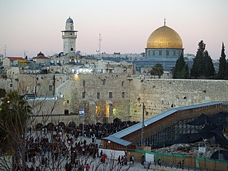
Tourism in Israel is a major economic sector and a significant source of national income. Israel offers a plethora of historical and religious sites, beach resorts, natural sites, archaeological tourism, heritage tourism, adventure tourism, and ecotourism. For practical reasons, this article also covers tourism in the West Bank and the Golan Heights, since it is closely interconnected with the mass tourism in Israel. In 2019, Israel saw a record 4.55 million tourist arrivals, with tourism contributing NIS 20 billion to the national economy in 2017.
Yehiam is a kibbutz in northern Israel. Located at the western Upper Galilee, eight miles east of the coastal town of Nahariya and 14 miles south-east of the border with Lebanon it falls under the jurisdiction of Mateh Asher Regional Council. In 2022 it had a population of 778. It is located around 365 meters above sea level
Beaufort or Belfort Castle, known locally as Qal'at al-Shaqif or Shaqif Arnun, is a Crusader fortress in Nabatieh Governorate, Southern Lebanon, about 1 kilometre (0.62 mi) to the south-south-east of the village of Arnoun. There was a fortification on the site before it was captured by Fulk, King of Jerusalem, in 1139 and construction of the Crusader castle probably began soon after. Saladin captured Beaufort in 1190, but 60 years later Crusaders re-took it. In 1268 Sultan Baibars finally captured the castle for the Islamic forces.

Hunin was a Palestinian Arab village in the Galilee Panhandle part of Mandatory Palestine, close to the Lebanese border. It was the second largest village in the district of Safed, but was depopulated in 1948. The inhabitants of this village were, similar to the inhabitants of Southern Lebanon, Shia Muslims.
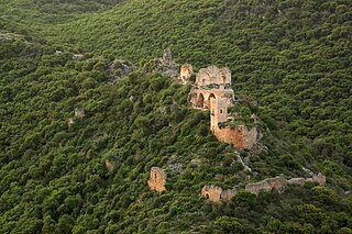
Montfort is a ruined Crusader castle in the Upper Galilee region in northern Israel, about 22 miles (35 km) northeast of the city of Haifa and 10 miles (16 km) south of the border with Lebanon.

Le Destroit is a ruined medieval fortified road station, built by the Templars of the Crusader Kingdom of Jerusalem in the early 12th century CE, located on the Mediterranean shore near a site where they later built the Chateau Pelerin castle, today close to the modern town of Atlit, Israel.

Ga'aton is a kibbutz in northern Israel. Located in the western Galilee, it falls under the jurisdiction of Mateh Asher Regional Council. In 2022 it had a population of 725.

Merhavia is a kibbutz in northern Israel. Located to the east of Afula, it falls under the jurisdiction of Jezreel Valley Regional Council. In 2022 it had a population of 1,331.

Tzova, also Palmach Tzova or Tzuba, is a kibbutz in central Israel. Located in the Judean Hills, on the western outskirts of Jerusalem, it falls under the jurisdiction of Mateh Yehuda Regional Council. In 2022 it had a population of 621.

Majdal Yaba was a Palestinian Arab village in the Ramle Subdistrict, 18.5 kilometres (11.5 mi) northeast of Ramla and 4 kilometres (2.5 mi) east of Jaffa. A walled Jewish settlement name Migdal Aphek stood at the same site as early as the second century BCE, and it was later destroyed by the Romans during the First Jewish–Roman War in 67 CE. In the Crusader period, a fort named Mirabel was built at the site. During the Islamic period it became known as Majdal Yaba. For a short time under Ottoman rule, its name was changed from Majdal Yaba to Majdal Sadiq and then back again.

Ein Hemed is a national park and nature reserve in the hills seven kilometres west of modern Jerusalem and some 12 kilometres west of the Old City. It is also known by the Latin name it received from the Crusaders, Aqua Bella, and as Khirbat Iqbalā in Arabic. The park is located on the path of an old Roman road, also used in later periods. The road connected the coastal plain with Jerusalem, passing through Bab al-Wad. A fortified Hospitaller building from the Crusader period, relatively well preserved, is arguably the main attraction beside the streams and lush vegetation.
Khirbat al-Tannur, also known as Allar al-Sifla, was a Palestinian Arab hamlet in the Jerusalem Subdistrict, near Allar. It was depopulated during the 1948 Arab–Israeli War on October 21, 1948, under Operation Ha-Har. It was located 18.5 km west of Jerusalem.
The Castle of al-Al, also ʿAlʿāl was, according to contemporary Damascene chronicler Ibn al-Qalanisi, a short-lived castle built in 1105 near al-‘Al on the Golan Heights by Hugh of Saint Omer, the man put in charge of the Galilee by King Baldwin I. The location is described as "between the Sawad and al-Bathaniya". Israeli historian Moshe Sharon considers it to be a mere legend rooted in a popular etymology, with no historical base.

The Inn of the Good Samaritan is a national park, museum, ancient archaeological site and former inn administered by the Israel Nature and Parks Authority located near Ma'ale Adumim, halfway between Jerusalem and Jericho, at an elevation of 298 meters above sea level.