East Godavari is a district in the Coastal Andhra region of Andhra Pradesh, India. Its district headquarters is at Kakinada. As of Census 2011, it became the most populous district of the state with a population of 5,151,549. Rajahmundry and Kakinada are the major cities in the district in terms of population.

West Godavari district or Paschima Godavari Jilla is one of the nine districts in the Coastal Andhra region of the Indian state of Andhra Pradesh. The administrative headquarters of the district is situated at Eluru. As of 2011 census of India, the district has an area of 7,742 km2 (2,989 sq mi) and a population of 3,936,966. It is bounded by Krishna district on the west, East Godavari district on the east, Bay of Bengal on the south and the state of Telangana on the north.

River Sarada is a medium-sized river in Visakhapatnam district of Andhra Pradesh, India.

Chintalapudi is a town and mandal headquarters in West Godavari district of the Indian state of Andhra Pradesh.
Poduru is a village and mandal headquarters of Poduru mandal in West Godavari district of the Indian state of Andhra Pradesh. The nearest railway station is located at Palakollu (PKO) at a distance of 7.4 km (4.6 mi).

Dharmavaram is a village in West Godavari district of the Indian state of Andhra Pradesh. It is located in Kovvur mandal.

Please do not contribute text in a foreign language to English Wikipedia. Your contributions are more than welcome at a Wikipedia in your language. Thank you.

Eluru mandal is one of the 46 mandals in West Godavari district of the Indian state of Andhra Pradesh. It is administered under Eluru revenue division and its headquarters are located at Eluru city. The mandal is bounded by Pedapadu mandal, Pedavegi mandal, Denduluru mandal, Bhimadole mandal and it also borders Krishna district.

National Highway 216 is a National Highway in the Indian state of Andhra Pradesh. The former highways of NH 214 and 214A were merged and renumbered as NH 216. It starts from NH 16 junction at Kattipudi and passes through Kakinada, Amalapuram, Digamarru (Palakollu), Narasapuram, Machilipatnam, Bapatla, Chirala before it junctions NH 16 again at Ongole. Visakhapatnam–Kakinada Petro Chemical Corridor, is a proposed project along the highway.

Doddipatla is a village in West Godavari district of the Indian state of Andhra Pradesh. It is located in Yelamanchili Mandal. The nearest railway station is at Kaikaram (KKRM) located at a distance of 10.5 Km.
Bhimadole mandal is one of the 46 mandals in West Godavari district of the Indian state of Andhra Pradesh. It is administered under Eluru revenue division and its headquarters are located at Bhimadole.

Tadepalligudem mandal is one of the 48 mandals in West Godavari district of the Indian state of Andhra Pradesh. It is under the administration of Eluru revenue division and the headquarters are located at Tadepalligudem. The mandal is bounded by Nallajerla, Devarapalle, Nidadavolu, Unguturu, Pentapadu, Tanuku and Undrajavaram mandals.

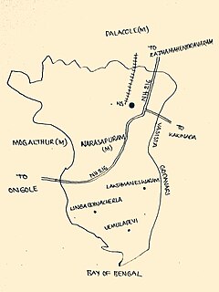
Narasapuram Mandal is one of the 46 mandals in the West Godavari district of the Indian state of Andhra Pradesh. Its headquarters are in Narasapuram, a town in the mandal. The mandal is bordered by the Godavari River to the north, the Bay of Bengal to the east, the Mogalthur mandal to the south, and the Palacole mandal to the west.

Biccavolu mandal is one of the 65 mandals in East Godavari district of the Indian state of Andhra Pradesh. It is under the administration of Rajahmundry revenue division and the headquarters are located at Biccavolu village. Biccavolu Mandal is bounded by Rayavaram Mandal towards South, Pedapudi Mandal towards East, Anaparthy Mandal towards west, Ramachandrapuram Mandal towards north. It is located ata distance of 41 kilometres from Rajahhmundry.

Palakollu mandal is one of the 46 mandals in the West Godavari district of the Indian state of Andhra Pradesh. The headquarters is located at Palakollu City. The mandal is bordered by Yelamanchili mandal in the north, Narasapuram mandal in the east, Poduru mandal in the south and Veeravasaram mandal in the west.

Yelamanchili mandal is amongst the 46 mandals in West Godavari district of the state of Andhra Pradesh in India. Its headquarters are located in the village of Yelamanchili. The mandal is bordered by the Godavari River to the north and east, the Palacole mandal to the south, and the Poduru and Achanta mandals to the west.

Achanta Mandal is one of the 46 mandals in West Godavari district of the Indian state of Andhra Pradesh. Its headquarters are located in Achanta. The mandal is bordered by Godavari river to the north, Yelamanchili mandal to the east, Poduru mandal to the south, and Penugonda mandal to the west.

Poduru mandal is one of 46 mandals in West Godavari district of the Indian state of Andhra Pradesh. The headquarters is located in the town of Poduru.


