Related Research Articles
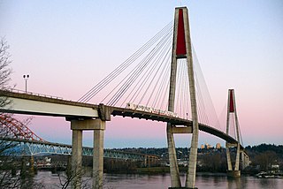
The SkyBridge is a cable-stayed bridge in Metro Vancouver, British Columbia, Canada. Built between 1987 and 1989, it spans the Fraser River and connects New Westminster with Surrey. The SkyBridge opened for revenue use on March 16, 1990, with the second half of the Phase II extension of SkyTrain to Scott Road station.
Terzaghi Dam is the key diversion dam in BC Hydro's Bridge River Power Project. It forms the project's largest reservoir, Carpenter Lake west of Lillooet. Originally known as the Mission Dam, it was renamed Terzaghi Dam in 1965 to honor Karl von Terzaghi, the civil engineer who founded the science of soil mechanics. It is located about 30 km up the Bridge River from its confluence with the Fraser.
Cottonwood River Provincial Park is a provincial park in British Columbia, Canada, located northeast of the confluence of the Fraser and Cottonwood Rivers in that province's North Cariboo region.
Fort George Canyon Provincial Park is a provincial park south of Prince George in British Columbia, Canada. The park's area is 440 acres (180 ha) and includes part of the Fraser River. No camping, campfires, swimming, kayaking, horses, pets, or rock climbing are allowed. Skiing, fishing, and hunting are allowed.
Fraser River Provincial Park is a provincial park in British Columbia, Canada.

The Mission Bridge is a steel girder bridge across the Fraser River, linking the District Of Mission to the City of Abbotsford, British Columbia, Canada. The bridge measures 1,126.2 m (3,695 ft) long and carries four lanes of British Columbia Highway 11. The bridge is the only fixed road crossing between Maple Ridge and Agassiz.
The Red Bluff First Nation is a Dakelh First Nations government located in the northern Fraser Canyon region of the Canadian province of British Columbia. It is a member of the Carrier-Chilcotin Tribal Council, which includes both Tsilhqot'in and Carrier (Dakelh) communities.
Toosey is a Tsilhqot'in First Nations community located west of the Fraser Canyon in the Chilcotin region of the Canadian province of British Columbia. It is a member of the Carrier-Chilcotin Tribal Council, which includes both Tsilhqot'in and Carrier (Dakelh) communities.

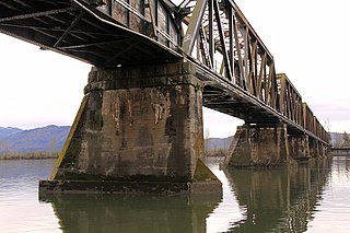
The CN Rail Bridge is a truss bridge over the Fraser River. It was built in 1914 by the Grand Trunk Pacific Railway and designed by Joseph Legrand. It is the longest railorad bridge in British Columbia.

The Bridge River Country is a historic geographic region and mining district in the Interior of British Columbia, Canada, lying between the Fraser Canyon and the valley of the Lillooet River, south of the Chilcotin Plateau and north of the Lillooet Ranges. "The Bridge River" can mean the Bridge River Country as opposed to the Bridge River itself, and is considered to be part of the Lillooet Country, but has a distinct history and identity within the larger region. As Lillooet is sometimes considered to be the southwest limit of the Cariboo, some efforts were made to refer to the Bridge River as the "West Cariboo" but this never caught on.
The Mission Railway Bridge is a Canadian Pacific Railway bridge spanning the Fraser River between Mission, and Abbotsford, British Columbia, Canada.
The Simon Fraser Bridge is a deck truss bridge on Highway 97, spanning the Fraser River in Prince George, British Columbia. It was originally a two-lane bridge, and was completed in 1963. It carries approximately 22,000 vehicles per day. In 2009, a 50 million dollar project to twin the bridge was completed. The new bridge carrying two lanes of northbound traffic is approximately 390 metres in length, whereas the two lanes of southbound traffic are directed across the original bridge.

Hixon is an unincorporated community at the northern edge of the Cariboo region of the Central Interior region of British Columbia, Canada. It is part of Electoral Area E in the Regional District of Fraser-Fort George. It is located on the east (left) bank of the Fraser River, and is about midway along BC Highway 97 between the cities of Prince George (N) and Quesnel (S). It was named for Hixon Creek, which in turn is named for a 19th-century prospector in the area, by the name of Joseph Foster Hixon, who found gold here on the banks of the Fraser River back around 1866.
The Katzie First Nation or Katzie Nation is the band government of the Katzie people of the Lower Fraser Valley region of British Columbia, Canada.
Kanaka Creek Regional Park is a regional park of the Greater Vancouver Regional District, located in the city of Maple Ridge, British Columbia, flanking both sides of Kanaka Creek from its confluence with the Fraser River just east of Haney and extending approximately 11 km up the creek to just south of the community of Webster's Corners.

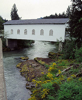
Stewart Bridge is a Howe truss covered bridge built in 1930 near Walden, Oregon, United States, in Lane County. It was listed on the National Register of Historic Places in 1979. It is 60 feet (18 m) long and crosses Mosby Creek, a tributary of the Row River.
Cottonwood River is a tributary of the Fraser River in the Central Interior of British Columbia, Canada. Rising at the confluence of the Swift River and Lightning Creek at Coldspring House in the Cariboo goldfields of the northern Cariboo Plateau, it flows northwest and then turns southwest to join the Fraser just north of the city of Quesnel, which is at the confluence of the Quesnel River with the Fraser.
Dog Creek is an unincorporated ranching settlement, located on the Fraser River, in the Cariboo region of British Columbia, Canada. Located on the northeast side of the Fraser's confluence with Dog Creek, it is opposite Gang Ranch on the west side of the river, which is connected by an old suspension bridge serving local ranch roads. Dog Creek's first post office opened in 1873. The Dog Creek reserves of the Canoe Creek/Dog Creek Indian Band are located east of the settlement. The ranches at Dog Creek, along with the Gang Ranch, mostly hire First Nations cowboys, most of them coming from the Canoe Creek/Dog Creek Band.
The Dorena Bridge is a covered bridge near Dorena in Lane County, Oregon in the United States. It is listed on the National Register of Historic Places. The 105-foot (32 m) structure crosses the Row River near the upper end of Dorena Reservoir.
Brownsville was a former community in what is now the City of Surrey, British Columbia, Canada. Also known as South Westminster, it was located where the city ran a small ferry across the Fraser River, today approximately where the east footing of the Skytrain bridge is, this was also the former site of qiqéyt, one of the main summer villages of the Musqueam people.
References
Coordinates: 53°54′36.1″N122°43′23.9″W / 53.910028°N 122.723306°W
| | This article about a specific bridge in Canada is a stub. You can help Wikipedia by expanding it. |
| | This article about transport in British Columbia is a stub. You can help Wikipedia by expanding it. |