
Thurston County is a county located in the U.S. state of Washington. As of the 2020 census, its population was 294,793. The county seat and largest city is Olympia, the state capital.

Rainier is a city in Thurston County, Washington, United States. Beginning as a train stop in the 1870s, Rainier was first settled in 1890 and would become known as a logging town. The city was officially incorporated in 1947.

Tenino is a city in Thurston County, Washington, United States. The population was 1,870 at the 2020 census.

Yelm is a city in Thurston County, Washington, United States. Its population was 10,617 at the 2020 census.

Union Bay is a body of water located in Seattle, Washington. Part of Lake Washington, it is bounded by the Laurelhurst neighborhood to the north and the Montlake and Madison Park neighborhoods to the south. The Evergreen Point Floating Bridge, which carries State Route 520, crosses over a portion of the bay.

The Nisqually River is a river in west central Washington in the United States, approximately 81 miles (130 km) long. It drains part of the Cascade Range southeast of Tacoma, including the southern slope of Mount Rainier, and empties into the southern end of Puget Sound. Its outlet was designated in 1971 as the Nisqually Delta National Natural Landmark.
The Washington State Department of Transportation is a governmental agency that constructs, maintains, and regulates the use of transportation infrastructure in the U.S. state of Washington. Established in 1905, it is led by a secretary and overseen by the governor. WSDOT is responsible for more than 20,000 lane-miles of roadway, nearly 3,000 vehicular bridges and 524 other structures. This infrastructure includes rail lines, state highways, state ferries and state airports.

Matthews Beach is a neighborhood in Seattle, Washington; it and Meadowbrook are the southern neighborhoods of the annexed township of Lake City (1954). Matthews Beach lies about 2 miles (3.2 km) northeast of the University of Washington, about 8 miles (13 km) northeast of Downtown.

Mineral is an unincorporated community and census-designated place (CDP) in Lewis County, Washington, on State Route 7 near the Pierce/Lewis county line. Mineral originally began as a logging camp and mining town. Prospectors searching the area for gold instead found coal and arsenic. By the early 1920s, the mines closed, and with a devastating fire to the town's largest sawmill, Mineral began to turn to tourism as its main industry, primarily through recreational fishing on Mineral Lake. The population was 193 at the 2020 census, down from 202 at the 2010 census.

The Chehalis Western Trail is a rail trail in Thurston County, Washington and is the longest shared-use path in the region. It occupies an abandoned railroad corridor that was once used by the historic Weyerhaeuser-owned Chehalis Western Railroad. The rail line was converted to a bicycle and walking trail and intersects with the 14.5-mile (23.3 km) Yelm-Rainier-Tenino Trail and the 4.7-mile (7.6 km) Karen Fraser Woodland Trail.
The Yelm–Rainier–Tenino Trail, formerly the Yelm–Tenino Trail, is a rail trail located in Thurston County, Washington, United States.

State Route 507 (SR 507) is a Washington state highway in Lewis, Thurston and Pierce counties that extends 43.52 miles (70.04 km) from Interstate 5 (I-5) and U.S. Route 12 (US 12) in Centralia to SR 7 in Spanaway. The highway also intersects SR 510 in Yelm and SR 702 in McKenna. The first appearance of the roadway on a map was in 1916 and since, two highways, Secondary State Highway 5H (SSH 5H) and SSH 1N, were established on the current route of SR 507 in 1937 and 1943. They both became SR 507 during the 1964 highway renumbering.

State Route 510 (SR 510) is a state highway in Thurston County, Washington. The 13 miles (20.9 km) long highway extends southeast from an interchange with Interstate 5 (I-5) in Lacey to SR 507 in Yelm. SR 510 roughly parallels the Nisqually River, the border between Thurston and Pierce counties, between the Fort Lewis and Nisqually Indian Community area to Yelm.

Timberland Regional Library (TRL) is a public library system serving the residents of western Washington state, United States including Grays Harbor, Lewis, Mason, Pacific, and Thurston counties. Timberland Regional Library has 27 community libraries, 2 cooperative library centers, and 3 library kiosks. It was founded in 1968, following a four-year demonstration project, and is funded through property taxes and timber taxes.
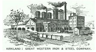
The Great Western Iron and Steel Company was a company founded in the 1890s in Kirkland, Washington Territory by the city's namesake Peter Kirk to build an integrated smelter and steel mill to refine local ore into steel for rails and other purposes. If the enterprise had proceeded as Kirk and other investors envisioned, it would have held a "practical monopoly of the entire Pacific Coast" steel production. But instead, the company went bankrupt in the Panic of 1893, and the mostly-completed mill never produced any steel. A scholar in 1962 called it "the last major effort of private capital to erect an integrated iron and steel mill on the West Coast".
Many glacial erratic boulders can be found in the Puget Sound region as far south as the Yelm area where the Puget Lobe of the glacier reached its maximum extent.

Southwest Washington is a geographical area of the U.S. state of Washington, encompassing roughly half of Western Washington. It generally includes the Olympia area southwards to the Oregon-Washington state line at Vancouver. Olympia, the state capital, has been a transshipment center for Southwest Washington since its settlement in the mid-19th century.

South Puget Sound is the southern reaches of Puget Sound in Southwest Washington, in the United States' Pacific Northwest. It is one of five major basins encompassing the entire Sound, and the shallowest basin, with a mean depth of 37 meters (121 ft). Exact definitions of the region vary: the state's Department of Fish and Wildlife counts all of Puget Sound south of the Tacoma Narrows for fishing regulatory purposes. The same agency counts Mason, Jefferson, Kitsap, Pierce and Thurston Counties for wildlife management. The state's Department of Ecology defines a similar area south of Colvos Passage.

The Point Defiance Bypass is a 14.5-mile-long (23.3 km) rail line between the cities of DuPont and Tacoma in Pierce County, Washington. It was originally built by the Northern Pacific Railway – the Tacoma–Lakewood segment in 1874 as part of the Prairie Line, and the Lakewood–DuPont section in 1891. Passenger service on the lines declined after the 1914 completion of a flatter route along Puget Sound, and ended entirely in 1956.
The Centralia Canal, also known as Centralia Power Canal, is a canal in Thurston and Pierce counties, Washington, United States. It is the only feature named a canal in Western Washington. The canal parallels the Nisqually River for 9 miles (14 km) in and around the city of Yelm. It was built in 1929 to supply water for the 12-megawatt Yelm hydroelectric project belonging to the city of Centralia's City Light Department.
