Africa is a continent comprising 63 political territories, representing the largest of the great southward projections from the main mass of Earth's surface. Within its regular outline, it comprises an area of 30,368,609 km2 (11,725,385 sq mi), excluding adjacent islands. Its highest mountain is Kilimanjaro; its largest lake is Lake Victoria.

The Great Victoria Desert is a sparsely populated desert ecoregion and interim Australian bioregion in Western Australia and South Australia.

The Sahara desert, as defined by the World Wide Fund for Nature (WWF), includes the hyper-arid center of the Sahara, between latitudes 18° N and 30° N. It is one of several desert and xeric shrubland ecoregions that cover the northern portion of the African continent.

The Sonoran Desert is a hot desert in North America and ecoregion that covers the northwestern Mexican states of Sonora, Baja California, and Baja California Sur, as well as part of the southwestern United States. It is the hottest desert in both Mexico and the United States. It has an area of 260,000 square kilometers (100,000 sq mi).

The Great Basin Desert is part of the Great Basin between the Sierra Nevada and the Wasatch Range. The desert is a geographical region that largely overlaps the Great Basin shrub steppe defined by the World Wildlife Fund, and the Central Basin and Range ecoregion defined by the U.S. Environmental Protection Agency and United States Geological Survey. It is a temperate desert with hot, dry summers and snowy winters. The desert spans large portions of Nevada and Utah, and extends into eastern California. The desert is one of the four biologically defined deserts in North America, in addition to the Mojave, Sonoran, and Chihuahuan Deserts.
The Lake Eyre basin is a drainage basin that covers just under one-sixth of all Australia. It is the largest endorheic basin in Australia and amongst the largest in the world, covering about 1,200,000 square kilometres (463,323 sq mi), including much of inland Queensland, large portions of South Australia and the Northern Territory, and a part of western New South Wales. The basin is also one of the largest, least-developed arid zone basins with a high degree of variability anywhere. It supports only about 60,000 people and has no major irrigation, diversions or flood-plain developments. Low density grazing that sustains a large amount of wildlife is the major land use, occupying 82% of the total land within the basin. The Lake Eyre basin of precipitation to a great extent geographically overlaps the Great Artesian Basin underneath.

A semi-arid climate, semi-desert climate, or steppe climate is a dry climate sub-type. It is located on regions that receive precipitation below potential evapotranspiration, but not as low as a desert climate. There are different kinds of semi-arid climates, depending on variables such as temperature, and they give rise to different biomes.

Anne Beadell Highway is an outback unsealed track linking Coober Pedy, South Australia, and Laverton, Western Australia, a total distance of 1,325 km (823 mi). The track was surveyed and built by Len Beadell, Australian surveyor, who named it after his wife.
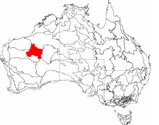
The Little Sandy Desert (LSD) is a desert region in the state of Western Australia, lying to the east of the Pilbara and north of the Gascoyne regions. It is part of the Western Desert cultural region, and was declared an interim Australian bioregion in the 1990s.

Newberry Springs is an unincorporated community in the western Mojave Desert of Southern California, located at the foot of the Newberry Mountains in San Bernardino County, California, United States. Newberry Spring is a spring that in the 19th century supplied water to the local Santa Fe Railway and originally was a camping place. The population at the 2000 census was 2,895.

Lake Carnegie is a large ephemeral lake in the Shire of Wiluna in the Goldfields-Esperance region of Western Australia. The lake is named after David Carnegie, who explored much of inland Western Australia in the 1890s. A similar lake lies to its south east - Lake Wells.
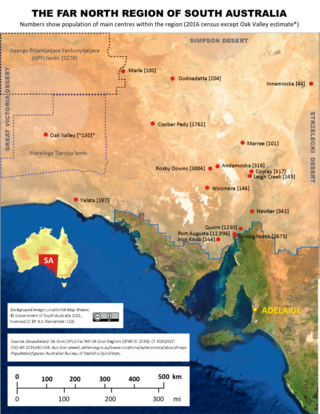
The Far North is a region that covers about 70 per cent of the Australian state of South Australia. It extends across the entire width of the state – about 1200 kilometres – for approximately the northernmost 750 kilometres. The state government defines the Far North region similarly, although it separately delineates the Maralinga Tjarutja Lands, the Yalata Aboriginal community and other unincorporated crown lands in the state's far west, which are officially considered part of the Eyre and Western region. Colloquially, South Australians regard anywhere north of Port Augusta as the Far North.
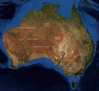
The deserts of Australia or the Australian deserts cover about 2,700,000 km2 (1,000,000 sq mi), or 18% of the Australian mainland, but about 35% of the Australian continent receives so little rain, it is practically desert. Collectively known as the Great Australian desert, they are primarily distributed throughout the Western Plateau and interior lowlands of the country, covering areas from South West Queensland, Far West region of New South Wales, Sunraysia in Victoria and Spencer Gulf in South Australia to the Barkly Tableland in Northern Territory and the Kimberley region in Western Australia.

The Great Central Road is a mostly unsealed Australian outback highway that runs 1,126 km (700 mi) from Laverton, Western Australia to Yulara, Northern Territory. It passes through a number of small communities on the way. It forms part of the Outback Way which goes all the way to Winton, Queensland.
The Date Creek Mountains is a short, arid range in southwest Yavapai County, Arizona. Congress is on its southeast foothills, and Wickenburg lies 15 mi (24 km) southeast.
Cosmo Newbery is a small Aboriginal community in Western Australia, 1,036 kilometres (644 mi) east of Perth between Laverton and Warburton in the Goldfields-Esperance region of Western Australia. In the 2011 census, Cosmo Newberry had a total population of 74, including 64 Aboriginal and Torres Strait Islander people.
The Desert Uplands is an interim Australian bioregion located in north and central western Queensland which straddles the Great Dividing Range between Blackall and Pentland.

Altun Shan National Nature Reserve is a large, arid area in the southeast of Xinjiang Autonomous Region, on the northern edge of the Tibetan plateau and the southern edge of the Tarim Basin in northwest China. It surrounds the Kumkol Basin, an endorheic basin in the western third of the Altyn-Tagh mountains. The reserve is sometimes referred to as the "Arjin Mountains Nature Reserve", or "Aerjinshan". The reserve covers the southern portions of Qiemo County and Ruoqiang County of Bayingolin Mongol Autonomous Prefecture in Xinjiang.

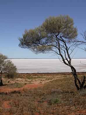
Lake Wells is an ephemeral salt lake in the centre of Western Australia, lying in close proximity to Lake Carnegie. It lies east of Wiluna and is at the southern edge of the Little Sandy Desert and south western border of the Gibson Desert. It also lies to the north west of the Great Central Road and the Great Victoria Desert. Its surface elevation is 436 metres above mean sea-level. Lake Wells has an area of 1895 square kilometres.
The Mandjindja, Mantjintjarra or Manytjilytjarra are an Aboriginal Australian people of Western Australia belonging to the Western Desert cultural bloc.