
North Korea is located in east Asia on the northern half of the Korean Peninsula.

Paektu Mountain or Baekdu Mountain is an active volcano on the China–North Korea border. At 2,744 m (9,003 ft), it is the highest mountain of the Changbai and Baekdudaegan ranges. Koreans assign a mythical quality to the volcano and its caldera lake, considering it to be their country's spiritual home. This mountain is called Changbai Mountain in China. It is the highest mountain on the Korean Peninsula and in Northeast China.

The Korean Peninsula is located in East Asia. It extends southwards for about 1,100 km (680 mi) from continental Asia into the Pacific Ocean and is surrounded by the Sea of Japan to the east and the Yellow Sea to the west, the Korea Strait connecting the two bodies of water.

Gyeonggi-do is the most populous province in South Korea. Its name, Gyeonggi means "the area surrounding the capital". Thus Gyeonggi-do can be translated as "province surrounding Seoul". The provincial capital is Suwon. Seoul—South Korea's largest city and national capital—is in the heart of the province but has been separately administered as a provincial-level special city since 1946. Incheon—South Korea's third-largest city—is on the coast of the province and has been similarly administered as a provincial-level metropolitan city since 1981. The three jurisdictions are collectively referred to as Sudogwon and cover 11,730 km2 (4,530 sq mi), with a combined population of 25.5 million—amounting to over half of the entire population of South Korea.

Buddhist temples are an important part of the Korean landscape. This article gives a brief overview of Korean Buddhism, then describes some of the more important temples in Korea. Most Korean temples have names ending in -sa, which means "temple" in Sino-Korean.

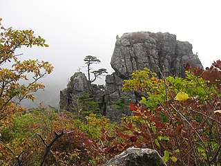
Chungju is a city in North Chungcheong province, South Korea. Namsan is a mountain located within the outskirts of the city.

Taebaek is a city in Gangwon province, South Korea. Its name is shared with that of the Taebaek Mountains. Situated at an altitude of 650 to 700 m, Taebaek is the highest city in South Korea.

Pyeongchang is a county in the province of Gangwon-do, South Korea, located in the Taebaek Mountains region. It is home to several Buddhist temples, including Woljeongsa. It is about 180 km (110 mi) east southeast of Seoul, the capital of South Korea, and connected by expressways and high-speed passenger railways. Pyeongchang's slogan, "Happy 700 Pyeongchang", is taken from its average elevation of approximately 700 metres (2,300 ft).
Jirisan is a mountain located in the southern region of South Korea. It is the second-tallest mountain in South Korea after Jeju Island's Hallasan, and the tallest mountain in mainland South Korea. After Jirisan, Seoraksan is the third tallest mountain in South Korea and the second-tallest mountain on the South Korean mainland.
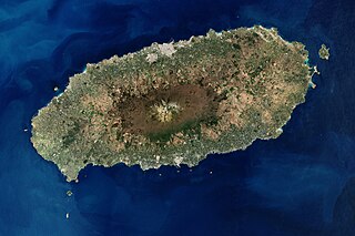
Jeju Island is an island in Jeju Province, South Korea. The island lies in the Korea Strait, south of South Jeolla Province. The island contains the natural World Heritage Site Jeju Volcanic Island and Lava Tubes. Jejudo has a moderate climate; even in winter, the temperature rarely falls below 0 °C (32 °F). Jeju is a popular holiday destination and a sizable portion of the economy relies on tourism and economic activity from its civil/naval base.
Cheonmasan is a mountain in Gyeonggi-do, South Korea. It can be found within the boundaries of the city of Namyangju. Cheonmasan has an elevation of 810.2 m (2,658 ft).
Cheonghwasan is a South Korean mountain between the county of Goesan, Chungcheongbuk-do and the city of Sangju, Gyeongsangbuk-do. It has an elevation of 984 m (3,228 ft).

Eunsusa is a small Korean Buddhist Temple that sits at the base of Sutmaibong (peak), or Elephant Rock, in the Maisan in Jinan County, North Jeolla Province, South Korea.

Taesŏngsan is a mountain in Taesong-guyok, Pyongyang, North Korea. It has an elevation of 270 metres (890 ft). One popular visitor attraction on Taesŏngsan is the outdoor ice rink. Others include the Revolutionary Martyrs' Cemetery and the Korea Central Zoo.
Jaeyaksan is a mountain of South Korea. It has an elevation of 1,108 metres. It is part of the Yeongnam Alps mountain range.
Amisan (아미산) is a mountain of Chungcheongnam-do, South Korea. It has an elevation of 630 metres (2,067 ft).

Maisan is a mountain of Jeollabuk-do, western South Korea. It has an elevation of 686 metres.
Muryongsan is a mountain of Jeollabuk-do, western South Korea. It has an elevation of 1,492 metres (4,895 ft).
Hwawangsan or Hwawang, is a mountain in Changnyeong County of South Gyeongsang Province, southeastern South Korea. It has an elevation of 757 metres.
Mangsan is a mountain of Gyeongsangnam-do, southeastern South Korea. It has an elevation of 406 metres.
