Related Research Articles

Holyhead is a historic port town, and is the largest town and a community in the county of Isle of Anglesey, Wales. Holyhead is on Holy Island, bounded by the Irish Sea to the north, and is separated from Anglesey island by the narrow Cymyran Strait, having originally been connected to Anglesey via the Four Mile Bridge.

Holy Island is an island on the western side of the larger Isle of Anglesey, Wales, from which it is separated by the Cymyran Strait. It is called "Holy" because of the high concentration of standing stones, burial chambers and other religious sites on the small island. The alternative English name of the island is Holyhead Island. According to the 2011 UK Census, the population was 13,659, of whom 11,431 (84%) lived in the largest town, Holyhead.

Rhosneigr is a village in the south-west of Anglesey, north Wales. It is situated on the A4080 road. It is south-east of Holyhead, and is on the Anglesey Coastal Path. From the clock at the centre of the village can be seen RAF Valley and Mynydd Twr. The towns of Holyhead and Llangefni and the city of Bangor are all within easy travelling distance.

Trearddur or Trearddur Bay is a village, seaside resort and community south of Holyhead on the west coast of Holy Island off the north-west coast of Anglesey in Wales. The community includes the small settlement of Penrhosfeilw and the Refail Farm estate.
The Anglesey Coastal Path is a 200-kilometre (124 mi) long-distance footpath around the island of Anglesey in North Wales. The route is part of the Wales Coast Path.

The Isle of Anglesey County Council is the local authority for the Isle of Anglesey, a principal area with county status in Wales. Since 2022 the council has 35 councillors who represent 11 multi-member electoral wards.

Gwynedd Council, which calls itself by its Welsh name Cyngor Gwynedd, is the governing body for the county of Gwynedd, one of the principal areas of Wales. The council administrates internally using the Welsh language.

Anglesey is an island off the north-west coast of Wales. It forms the bulk of the county known as the Isle of Anglesey, which also includes Holy Island and some islets and skerries. The county borders Gwynedd across the Menai Strait to the southeast, and is otherwise surrounded by the Irish Sea. Holyhead is the largest town, and the administrative centre is Llangefni. The county is part of the preserved county of Gwynedd. Anglesey is the northernmost county in Wales.

Llanbedrgoch is a hamlet and post town, a mile south of the town of Benllech and west of Red Wharf Bay, on the island of Anglesey, north Wales. The parish church is St Peter's Church, Llanbedrgoch, a Grade II* listed building that dates back to the 15th century.
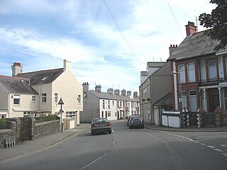
Kingsland is an area in the community of Holyhead, Anglesey, Wales.
Morawelon is an area and community electoral ward in the town of Holyhead, Anglesey, Wales.

Cymyran Strait is a strait that runs from Beddmanarch Bay in the north to Cymyran Bay in the south between the islands of Anglesey and Holy Island. At either end it opens up into the Irish Sea.

St Gwenfaen's Well is an early medieval holy well in the south west of Holy Island, Anglesey, named after St Gwenfaen, whose cloister was nearby. The site includes substantial remains of a building and is both a scheduled monument and a Grade II listed building. Traditionally, a gift of two white quartz pebbles thrown into the pool can cure mental health problems.
The Isle of Anglesey electoral boundary changes in 2012 reduced the numbers of electoral wards to the Isle of Anglesey County Council from 40 to 11. This led to the postponement of local government elections in the county by 12 months. The changes were confirmed by the Isle of Anglesey Order 2012 in October 2012.
The 2008 Isle of Anglesey County Council election took place on Thursday 1 May 2008 to elect members of the Isle of Anglesey County Council in Wales. This was the same day as other United Kingdom local elections. The previous full council election was on 10 June 2004 and the next full council election was held on 2 May 2013.

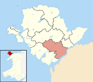
Caergybi is an electoral ward in Holyhead, Anglesey, Wales. It includes the northern half of the community including the town centre and port. Caergybi elects three county councillors to the Isle of Anglesey County Council. Caergybi includes the community wards of Town, London Road, Morawelon, Porthafelin and Parc a'r Mynydd, which elect representatives to Holyhead Town Council.

Holyhead Town Council is an elected community council serving the town of Holyhead in Anglesey, Wales.
Maeshyfryd is an area southwest of the port and town centre of Holyhead in Anglesey, Wales. It was formerly an electoral ward to the county council.
Bro Rhosyr is an electoral ward in the south of Anglesey, Wales, created in 2012.
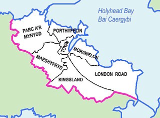
Parc a'r Mynydd is an area and community electoral ward in the town of Holyhead, Anglesey, Wales.
References
- 1 2 "Anglesey election candidate hits campaign trail in caravan as 'new ward is so big'". North Wales Live. 21 March 2013. Retrieved 30 March 2019.
- 1 2 3 "Isle of Anglesey (Electoral Arrangements) Order 2012" (PDF). legislation.gov.uk. The National Archives . Retrieved 30 March 2019.
- ↑ "Isle of Anglesey - Wards within Isle of Anglesey". UK Census Data. Retrieved 31 March 2019.
- ↑ "Anglesey County Council Elections - Latest". North Wales Chronicle. 3 May 2013. Retrieved 30 March 2019.
- ↑ Dale Spridgeon (5 May 2017). "No party wins overall control on Anglesey". North Wales Chronicle. Retrieved 30 March 2019.
- 1 2 "Election results for Ynys Gybi - Isle of Anglesey County Council Elections May 2017 - Thursday, 4th May, 2017". Isle of Anglesey County Council. Retrieved 30 March 2019.