Yoctangee Park

Last updated
Yoctangee Park
Yoctangee Park - Chillicothe, Ohio (2018).jpg
Yoctangee Park
Type Public
Location Chillicothe, Ohio
Coordinates 39°20′21.530″N82°59′4.700″W / 39.33931389°N 82.98463889°W / 39.33931389; -82.98463889 Coordinates: 39°20′21.530″N82°59′4.700″W / 39.33931389°N 82.98463889°W / 39.33931389; -82.98463889

Yoctangee Park is a public park in Chillicothe, Ohio, adjacent to the Historic First Capital District. City Park was the official name of the park from its establishment in 1875 until it was changed to Yoctangee Park sometime in the 1890s by William H. Hunter.

Contents

The name Yoctangee is a Native American word for "paint", a reference to the skin and clothing pigments of the culture native to the area.

History

The park was once known as the "Old Bed" of the River, or the "Island", because the old Marietta and Cincinnati Railroad (now the Baltimore and Ohio) built an embankment to redirect the Scioto River, leaving a marshy river bed with an island left in the center where the river once flowed through the park. For twenty years afterwards Chillicotheans attributed the chills and fever and the shaking ague to the overgrowth in the park, and every epidemic of malaria was attributed to the area, considered a plague spot.

The "Old Bed" is a part of the original Ebenezer Zane Section. This man of history is the one who blazed the trail from Wheeling to Maysville, at the beginning of the nineteenth century, under a contract with the Government, that for his services in laying out the large highway, he was to receive, at the crossing of every navigable stream, a full section of land at Wheeling one near Lancaster, and one down on the Ohio River across from Maysville, he was given a patent right by the United States of America to a plot of ground, on February 14, 1800, and surveyed the required area which ran Northwardly for the South bank of the old Scioto River, between what are now Bridge and Mill Streets, and Northwardly, almost up to Hopetown. Zanesville got its name from Ebenezer Zane, and Zane's Trace and Trail is to become a National Pike.

After the Civil War, Chillicothe's newspapers regularly had communications from citizens and physicians, demanding that the great nuisance of the "Old Bed" had to be abated. There came a demand for the acquirement of this spot by the city, for the purpose of draining and cleaning up this pestilential and poisonous cesspool.

To finance the purchase of the property, Honorable John H. Putnam member of the Ohio Legislature from this city, had a special Act passed, whereby the municipality had a right to levy a tax for the purchase.

It appears that out of the virulence of the miasma and much shaking for ague, grew the demand for a clean-up of the unhealthy zone, and contemporaneously there happened to be an abnormal amount of unemployment, so that when the proposition was put to the Council to eradicate the evil, there were willing hands.

Historical landmarks

The Pump House Center for the Arts occupies the building which was once Chillicothe's pump house and is now part of Yoctangee Park. The 1882 historical brick building offers tours rentals, and free admission.

The Pump House Center for the Arts is housed in the former Pump House of the Chillicothe Water and Sewer Co. The Pump House was constructed in 1883 as a municipal pumping station for distribution of water from the deep well field located in Yoctangee Park to a reservoir situated on Carlisle Hill. In March 1977, the Pump House was placed on the Ohio History Inventory. On November 15, 1979, it was listed in the National Register of Historic Places kept by the U.S. Department of Interior. The Pump House was used by the Jaycees group for its annual Haunted House fund-raiser until it was condemned in 1984 as unsafe. A group of artists, preservationists, and an attorney formed a coalition to restore and preserve the building. In 1986, City Council designated the Pump House as part of the city’s Preservation District. Coursework was replaced, bricks were repaired, floors were poured, electricity and water was installed, and the walls were rebuilt. The rooms were transformed into a beautiful art gallery where works could be displayed. The Pump House is an example of Victorian Gothic architecture, featuring a large central tower, Palladian windows, common-bond brick, and a low-pitched, hipped slate roof.

The city owns the former National Guard armory in what is now Yoctangee Park. The building was originally built in the early 20th century. Council has yet to decide what to do with the armory and has mothballed it. There have been a few ideas suggested for the building, such as a military museum or an orangerie, but due to lack of funding nothing has moved forward.

Two historic B&O Railroad caboose cars are on display in Yoctangee Park bordering Water Street. The cars were restored by volunteers who have collected railroad memorabilia and put items on display in the cars. Tours are given on weekdays starting in spring until early fall.

Geography and facilities

This stone arch bridge crossing Yoctangee Lake is a noteworthy landmark in Chillicothe. Yoctangee Park Lake Bridge.JPG
This stone arch bridge crossing Yoctangee Lake is a noteworthy landmark in Chillicothe.

Geography

Yoctangee Park Lake is a 12-acre (49,000 m2) lake contained within Yoctangee Park. Canoeing is sometimes available on the lake during festivals or by reservation.

Facilities

Swimming pool, six tennis courts, basketball and volleyball courts, baseball/softball diamonds, picnicking facilities, playground, shelter houses, grandstand, restrooms.

Park annex

An annex to the original Yoctangee Park area provides 40+ acres of soccer and baseball/softball fields to the north, and a boat access to the river on the south end. The Chillicothe Youth Soccer League (CYSL) and YMCA provide youth soccer leagues in this area.

Events

Hoverally

Hoverclub of America sponsors an annual hovercraft race is held in the Yoctangee Park Annex, spanning a section of park land and circling a small island area in the Scioto River. It is even claimed to be the largest hovercraft event in the world 1. It unfortunately was cancelled in 2009.

Feast of the Flowering Moon

This is a three-day event held in late May. The festival is held in Yoctangee Park, and most years also along Water St. between Mulberry and Walnut streets, and Paint St. from the Park to US-50. It typically features Native American Music, Dancing, Food, Arts & Crafts, Story Telling, Educational Demonstrations and much more. Special Guests have included: Douglas Blue Feather, 2002 & 2003 NAMMY Winner. Joseph FireCorw, 2003 NAMMY Winner. Native Violinist Arvel Bird of Singing Wolf Records.

Also see the Chillicothe, Ohio article on this topic.

Farmer's Fall Festival

The Farmer's Fall Festival, or Fall Harvest Festival is often held the first weekend in October. The festival has entertainment, crafts, flea market and more.

Concerts

The Columbus Symphony Orchestra performs a free concert annually in Yoctangee Park. Various passing bands perform concerts in the park from time to time as well.

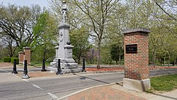
Bicentennial renovations

The entrance to Yoctangee Park was partially completed in 2003 and completed in 2004 at a total cost of $286,000.

A 2-acre (8,100 m2) part just north of the Water Shop on Yoctangee Blvd. is dedicated as a Veterans Memorial Park honoring all World War II veterans. [1]

Bibliography

Allen, Gertrude C. "History of the City Parks of Chillicothe, Ohio." The Chillicothe Parks and Recreation Office.

Related Research Articles

<span class="mw-page-title-main">Ohio River</span> Major river in the midwestern United States

The Ohio River is a 981-mile (1,579 km) long river in the United States. It is located at the boundary of the Midwestern and Southern United States, flowing southwesterly from western Pennsylvania to its mouth on the Mississippi River at the southern tip of Illinois. It is the third largest river by discharge volume in the United States and the largest tributary by volume of the north-south flowing Mississippi River that divides the eastern from western United States. It is also the 6th oldest river on the North American continent. The river flows through or along the border of six states, and its drainage basin includes parts of 14 states. Through its largest tributary, the Tennessee River, the basin includes several states of the southeastern U.S. It is the source of drinking water for five million people.

<span class="mw-page-title-main">Marshall County, West Virginia</span> County in West Virginia, United States

Marshall County is a county in the U.S. state of West Virginia. At the 2020 census, the population was 30,591. Its county seat is Moundsville. With its southern border at what would be a continuation of the Mason-Dixon line to the Ohio River, it forms the base of the Northern Panhandle of West Virginia.

<span class="mw-page-title-main">Maysville, Kentucky</span> City in Kentucky, United States

Maysville is a home rule-class city in Mason County, Kentucky, United States and is the seat of Mason County. The population was 8,782 as of 2019, making it the 51st-largest city in Kentucky by population. Maysville is on the Ohio River, 66 miles (106 km) northeast of Lexington. It is the principal city of the Maysville Micropolitan Statistical Area, which includes Mason and Lewis counties. Two bridges cross the Ohio from Maysville to Aberdeen, Ohio: the Simon Kenton Memorial Bridge built in 1931 and the William H. Harsha Bridge built in 2001.

<span class="mw-page-title-main">Martins Ferry, Ohio</span> City in Ohio, United States

Martins Ferry is a city in Belmont County, Ohio, United States, on the Ohio River across from Wheeling, West Virginia. It is the largest city in Belmont County. The population was 6,915 as of the 2010 census.

<span class="mw-page-title-main">Zanesville, Ohio</span> City in Ohio, United States

Zanesville is a city in and the county seat of Muskingum County, Ohio, United States. It is located 52 miles (84 km) east of Columbus and had a population of 24,765 as of the 2020 census, down from 25,487 as of the 2010 census. Historically the state capital of Ohio, Zanesville anchors the Zanesville micropolitan statistical area, and is part of the greater Columbus-Marion-Zanesville combined statistical area.

<span class="mw-page-title-main">Chillicothe, Ohio</span> City in Ohio, United States

Chillicothe is a city in and the county seat of Ross County, Ohio, United States. Located along the Scioto River 45 miles (72 km) south of Columbus, Chillicothe was the first and third capital of Ohio. It is the only city in Ross County and is the center of the Chillicothe, OH Micropolitan Statistical Area. The population was 22,059 at the 2020 census. Chillicothe is a designated Tree City USA by the National Arbor Day Foundation.

<span class="mw-page-title-main">Portsmouth, Ohio</span> City in Ohio, United States

Portsmouth is a city in and the county seat of Scioto County, Ohio, United States. Located in southern Ohio 41 miles (66 km) south of Chillicothe, it lies on the north bank of the Ohio River, across from Kentucky, just east of the mouth of the Scioto River. The population was 20,226 at the 2010 census. Portsmouth also stands as the state's 88th most populated city.

<span class="mw-page-title-main">Wheeling, West Virginia</span> City in West Virginia, United States

Wheeling is a city in the U.S. state of West Virginia. Located almost entirely in Ohio County, of which it is the county seat, it lies along the Ohio River in the foothills of the Appalachian Mountains and also contains a tiny portion extending into Marshall County. Wheeling is located about 60 miles (96 km) west of Pittsburgh and is the principal city of the Wheeling metropolitan area. As of the 2020 census, the metro area had a population of 145,205, and the city itself had a population of 27,062.

<span class="mw-page-title-main">Scioto River</span> Waterway in Ohio

The Scioto River is a river in central and southern Ohio more than 231 miles (372 km) in length. It rises in Hardin County just north of Roundhead, Ohio, flows through Columbus, Ohio, where it collects its largest tributary, the Olentangy River, and meets the Ohio River at Portsmouth. Early settlers and Native Americans used the river for shipping, but it is now too small for modern commercial craft. The primary economic importance for the river now is for recreation and drinking water. It is the longest river that is entirely within Ohio.

<span class="mw-page-title-main">Ebenezer Zane</span> American politician

Ebenezer Zane was an American pioneer, soldier, politician, road builder and land speculator. Born in the Colony of Virginia, Zane established a settlement near Fort Henry which became Wheeling, on the Ohio River. He also blazed an early road through the Ohio Country to Limestone known as Zane's Trace.

<span class="mw-page-title-main">Zane's Trace</span>

Zane's Trace is a frontier road constructed under the direction of Col. Ebenezer Zane through the Northwest Territory of the United States, in what is now the state of Ohio. Many portions were based on traditional Native American trails. Constructed during 1796 and 1797, the road ran from Wheeling, Virginia to Maysville, Kentucky, through the portion of the Northwest Territory that eventually became the southeastern quarter of the state of Ohio. It was more than 230 miles (370 km) long and was interrupted by several rivers.

The Southern Ohio Storytelling Festival is an annual storytelling festival held Thursday through Saturday after Labor Day in Chillicothe, Ohio. Local, regional and nationally known storytellers are invited to perform their favorite stories for thousands of school children and storytelling enthusiasts. A board of community volunteers and local/regional storytellers makes up the 503(c) non-profit organization that is responsible for organizing and overseeing the festival.

<span class="mw-page-title-main">Franklinton (Columbus, Ohio)</span> Neighborhood in Columbus, Ohio

Franklinton is a neighborhood in Columbus, Ohio, just west of its downtown. Settled in 1797, Franklinton is the first American settlement in Franklin County, and was the county seat until 1824. As the city of Columbus grew, the city annexed and incorporated the existing settlement in 1859. Franklinton is bordered by the Scioto River on the north and east, Harmon Avenue on the east, Stimmel Road and Greenlawn Avenue on the south, and Interstate 70 on the west. Its main thoroughfare is West Broad Street, one of the city's two main roads.

The Zane family was important to the early history and settlement of western Virginia and the U.S. state of Ohio. Brothers Ebenezer (1747–1811) and Isaac Zane both served in the Virginia House of Delegates before moving westward. They laid out sections of the Ohio Country, including the municipalities of Zanesville and Zanesfield. Their sister Betty Zane (1759–1823), was a heroine of the Revolutionary War.

<span class="mw-page-title-main">Unioto High School</span> High school in Ohio, United States

Unioto High School is a public high school near Chillicothe, Ohio. It is the only high school in the Union-Scioto Local School District. The school colors are purple and gold. The name Unioto is a portmanteau of the two townships that the school district primarily serves in Ross County: Union Township and Scioto Township.

<span class="mw-page-title-main">Zane Trace High School</span> Public school in Chillicothe, Ohio, United States

Zane Trace High School is a public high school near Chillicothe, Ohio, seated along the shores of Kinnikinnick Creek. It is the only high school in the Zane Trace Local School District. Their nickname is the Pioneers, and their colors are red, blue, and white. Their sports programs include: football, boys and girls cross country, boys and girls soccer, boys and girls basketball, volleyball, cheerleading, boys and girls track, boys and girls bowling, swimming, softball, baseball, wrestling, and e-sports.

<span class="mw-page-title-main">Zane's Tracts</span>

Zane's Tracts were three parcels of land in the Northwest Territory of the United States, later Ohio, that the federal government granted to Ebenezer Zane late in the 18th century, as compensation for establishing a road with ferry service over several rivers.

<span class="mw-page-title-main">Chillicothe Water and Power Company Pumping Station</span> United States historic place

The Chillicothe Water and Power Company Pumping Station is a historic building on the northern side of Chillicothe, Ohio, United States. A Gothic Revival structure built in 1881, it was constructed to house the city's waterworks and power plant. Its architecture and its location in Yoctangee Park was chosen specifically in order to beautify the park as well as to have a location near other elements of the city's first waterworks, which were built at the same time as the pumping station.

<span class="mw-page-title-main">Siege of Fort Henry (1782)</span>

The second siege of Fort Henry took place from September 11 to 13, 1782, during the American Revolutionary War. A force of about 300 Wyandot, Shawnee, Seneca and Lenape laid siege to Fort Henry, an American outpost at what is now Wheeling, West Virginia, accompanied by a force of 50 Loyalist soldiers from Butler's Rangers, a provincial military unit. The siege is commonly known as "The Last Battle of the Revolutionary War," despite subsequent skirmishes between Patriots and Loyalists involving the loss of life taking place in New Jersey later in 1782. However, these were unorganized outbreaks of fighting between patrons with opposing sentiments rather than engagements between belligerents.

<span class="mw-page-title-main">Rushville Historic District</span> Rushville Ohio Historic District

The Rushville Historic District is a historic district in Richland Township, Fairfield County Ohio which bounds the original village of Rushville. The district is considered both historically and architecturally significant due to the preservation of many houses and commercial buildings representing a period from the 1820s to the early 1900s. It features examples of log construction, Gothic Revival, Federal, Italianate, and Queen Anne style architecture.

References