
Tovdal is a former municipality in Aust-Agder county, Norway. The 377-square-kilometre (146 sq mi) municipality existed from 1908 until its dissolution in 1967. Tovdal municipality was made up of the valley surrounding the river Tovdalselva and since 1967 it has been a part of the present-day municipality of Åmli. The administrative centre of the municipality was the village of Hillestad where the Tovdal Church is located.
Vegår is a lake in the municipality of Vegårshei in Aust-Agder county, Norway. The 17.7-square-kilometre (6.8 sq mi) lake is located about 3 kilometres (1.9 mi) north of the municipal center of Myra and about 12 kilometres (7.5 mi) east of the village of Åmli in the neighboring municipality of Åmli.

Måvatn is a lake in the municipality of Åmli in Aust-Agder county, Norway. It is located about 2.5 kilometres (1.6 mi) northeast of the village of Askland in the Gjøvdal valley and about 1 kilometre (0.62 mi) south of the municipal border with Nissedal in Telemark county.
Nasvatn is a lake in the municipality of Åmli in Aust-Agder county, Norway. It is located about 3.5 kilometres (2.2 mi) north of the village of Hillestad in the mountains above the Tovdal river valley. The lake has a small dam on the southwestern end, and the water leaving the lake goes down a large waterfall and eventually drains in the river Tovdalselva.
Botsvatn or Bossvatn is a lake in the municipality of Bykle in Aust-Agder county, Norway. The 14.6-kilometre (9.1 mi) long, narrow reservoir is located just to the southeast of the large lake Blåsjø and northeast of the lake Ytre Storevatnet. The lake holds water for the Brokke Hydroelectric Power Station, located in nearby Valle municipality. The water from the lake can flow out into the nearby river Otra, but only when water is released from the dam.
Nelaug is a lake in the municipalities of Froland and Åmli in Aust-Agder county, Norway. The 10 kilometres (6.2 mi) lake is formed by a dam which regulates a hydroelectric power plant on the Nidelva river. The village of Nelaug is located near the dam in Froland municipality. The lake is located about 11 kilometres (6.8 mi) south of the village of Åmli, about 15 kilometres (9.3 mi) southeast of the village of Dølemo, and about 20 kilometres (12 mi) north of Blakstad.
Ytre Storevatnet is a lake in the municipality of Bykle in Aust-Agder county, Norway. The 2.8-square-kilometre (1.1 sq mi) lake makes up the northernmost part of the Svartevatnet reservoir that empties into the Sira River system. The lake is located just south of the lake Blåsjø and southwest of Botsvatn. The village of Bykle is about 25 kilometres (16 mi) northeast of the lake.
Flaten is a village in the municipality of Åmli in Aust-Agder county, Norway. It is located along the river Nidelva, about 4 kilometres (2.5 mi) southeast of the village of Nelaug. The population (2001) of Flaten was 32. The village has a railway station, Flaten Station, which is part of the Arendalsbanen railway line.

Dølemo is a village in the municipality of Åmli in Aust-Agder county, Norway. The village has a population of about 200. It is home to the municipal kindergarten, an elementary school, a shop, and many thriving clubs and organizations. Dølemo is often called "the voluntary village", the reason for this being the citizens' dedication when the annual Dølemo Market has to be arranged in the last week of August. The village sits at the intersection of the Norwegian National Road 41 and the Norwegian County Road 413. The village of Eppeland lies about 1.5 kilometres (0.93 mi) to the northeast, the village of Vehus lies about 5 kilometres (3.1 mi) to the south, and the village of Ytre Ramse lies about 10 kilometres (6.2 mi) to the northwest.

Askland is a village in Åmli municipality in Aust-Agder county, Norway. The village is located in the Gjøvdal valley, just north of the river Gjøv. The village of Homdrom lies about 9 kilometres (5.6 mi) to the southeast and the municipal centre of Åmli lies about 20 kilometres (12 mi) to the southeast. From 1908 until 1960, the Gjøvdal valley was the separate municipality of Gjøvdal which had Askland as its administrative centre. Gjøvdal Church is located in Askland.
Eppeland is a village in Åmli municipality in Aust-Agder county, Norway. The village is located along the Norwegian National Road 41, about 1.5 kilometres (0.93 mi) northeast of the village of Dølemo and about 10 kilometres (6.2 mi) southwest of the municipal centre of Åmli.
Homdrom is a village in Åmli municipality in Aust-Agder county, Norway. The village is located in the Gjøvdal valley about 13 kilometres (8.1 mi) northwest of the village of Åmli and about 8 kilometres (5.0 mi) southeast of the village of Askland.
Tveit is a village in Åmli municipality in Aust-Agder county, Norway. The village is located about 2.5 kilometres (1.6 mi) east of the municipal centre of Åmli on the other side of the mountain Tveitfjellet.
Vehus is a village in Åmli municipality in Aust-Agder county, Norway. The village is located just east of the river Nidelva, about 5.5 kilometres (3.4 mi) south of the village of Dølemo.
Øvre Ramse is a village in Åmli municipality in Aust-Agder county, Norway. The village is located along the river Tovdalsåna in the Tovdal valley. The village is about 3.5 kilometres (2.2 mi) north of the village of Ytre Ramse and about 14 kilometres (8.7 mi) northwest of the village of Dølemo. The village of Hillestad and the Tovdal Church lie about 4 kilometres (2.5 mi) to the northwest of Øvre Ramse.

Norwegian National Road 41 is a Norwegian national road that runs through Telemark, Aust-Agder, and Vest-Agder counties in Norway. The road runs between the village of Brunkeberg in Kviteseid municipality in Telemark county in the north and Timenes in Hånes in the city of Kristiansand in Vest-Agder county in the south. The 172.9-kilometre (107.4 mi) long road connects to the European route E134 highway in the north and to the European route E18 highway in the south. The road runs for 12.5 kilometres (7.8 mi) in Vest-Agder county, 89 kilometres (55 mi) in Aust-Agder county, and 71.4 kilometres (44.4 mi) in Telemark county. The southern half of the road runs along the river Tovdalselva and the lake Herefossfjorden, and it is located in a fault zone called the Kristiansand-Porsgrunn grabenen.

Østre Agder is a district or region in Aust-Agder county in southern Norway. The district covers the eastern, coastal areas of the county including the eight municipalities of Arendal, Tvedestrand, Risør, Grimstad, Gjerstad, Vegårshei, Åmli, and Froland. The city of Arendal is the largest city in the region. Other cities in the district include Tvedestrand, Grimstad, and Risør. This region is bounded by Telemark county to the north, by the Setesdal region to the northwest, and by the Kristiansand Region to the southwest.

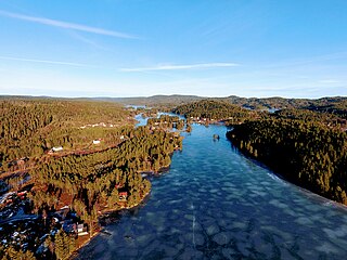
Åmli is the administrative centre of Åmli municipality in Aust-Agder county, Norway. The village is located along the Norwegian National Road 41 and the river Nidelva, about 30 kilometres (19 mi) northwest of the town of Tvedestrand via the Norwegian County Road 415. The village of Nelaug lies about 15 kilometres (9.3 mi) to the southeast and the village of Dølemo lies about 10 kilometres (6.2 mi) to the southwest. The 0.8-square-kilometre (200-acre) village has a population (2017) of 682 which gives the village a population density of 853 inhabitants per square kilometre (2,210/sq mi).
Hillestad is a village in Åmli municipality in Aust-Agder county, Norway. The village is located in the Tovdal valley along the river Tovdalselva. It sits about 4 kilometres (2.5 mi) northwest of the village of Øvre Ramse and about 15 kilometres (9.3 mi) northwest of the village of Dølemo. From 1908 until 1967, the valley was a separate municipality called Tovdal and during that time, Hillestad was its administrative centre. Tovdal Church is located in the village.


