
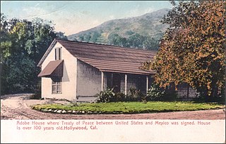
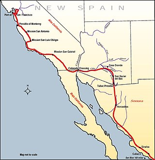
The Juan Bautista de Anza National Historic Trail is a 1,210-mile (1,950 km) trail extending from Nogales on the U.S.-Mexico border in Arizona, through the California desert and coastal areas in Southern California and the Central Coast region to San Francisco. The trail commemorates the 1775–1776 land route that Spanish commander Juan Bautista de Anza took from the Sonora y Sinaloa Province of New Spain in Colonial Mexico through to Las Californias Province. The goal of the trip was to establish a mission and presidio on the San Francisco Bay. The trail was an attempt to ease the course of Spanish colonization of California by establishing a major land route north for many to follow. It was used for about five years before being closed by the Quechan (Yuma) Indians in 1781 and kept closed for the next 40 years. It is a National Historic Trail administered by the National Park Service and was also designated a National Millennium Trail.

Fort Yuma was a fort in California located in Imperial County, across the Colorado River from Yuma, Arizona. It was Established in 1848. It served as a stop on the Butterfield Overland Mail route from 1858 until 1861. The fort was retired from active military service on May 16, 1883, and transferred to the Department of the Interior. The Fort Yuma Indian School and the Saint Thomas Yuma Indian Mission now occupy the site. It is one of the "associated sites" listed as Yuma Crossing and Associated Sites on the National Register of Historic Places in the Yuma Crossing National Heritage Area. In addition, it is registered as California Historical Landmark #806.

Yuma Quartermaster Depot State Historic Park, formerly Yuma Crossing State Historic Park, and now one of the Yuma Crossing and Associated Sites on the National Register of Historic Places in the Yuma Crossing National Heritage Area. It is an Arizona state park in the city of Yuma, Arizona, US.
Sackett's Wells is a former settlement in Imperial County, California. It was located 3 miles (4.8 km) west northwest of Plaster City, in or near Coyote Wash.
In the history of the American frontier, pioneers built overland trails throughout the 19th century, especially between 1829 and 1870, as an alternative to sea and railroad transport. These immigrants began to settle much of North America west of the Great Plains as part of the mass overland migrations of the mid-19th century. Settlers emigrating from the eastern United States did so with various motives, among them religious persecution and economic incentives, to move from their homes to destinations further west via routes such as the Oregon, California, and Mormon Trails. After the end of the Mexican–American War in 1849, vast new American conquests again encouraged mass immigration. Legislation like the Donation Land Claim Act and significant events like the California Gold Rush further encouraged settlers to travel overland to the west.

The Yuma War was the name given to a series of United States military operations conducted in southern California and what is today southwestern Arizona from 1850 to 1853. The Quechan were the primary opponent of the United States Army, though engagements were fought between the Americans and other native groups in the region.

The Mohave War was an armed conflict between the Mohave people and the United States from 1858 to 1859. With the California Gold Rush of 1849, thousands of American settlers headed west through Mohave country and into California. The influx of migrants passing through, combined with simple misunderstandings, led to conflict. Fort Mohave on the Arizona side of the Colorado River was built for operations against the Mohave and was the second American military post established on the river after Fort Yuma. Eventually advantages in weaponry and tactics brought the Mohave and their allies to surrender. After the signing of a peace treaty in 1859, the Mohave no longer opposed the United States through warfare. The peace also ended a long guerrilla war between the Mohave and the Maricopa of south central Arizona.
The Butterfield Overland Mail in California was created by the United States Congress on March 3, 1857, and operated until June 30, 1861. Subsequently, other stage lines operated along the Butterfield Overland Mail in route in Alta California until the Southern Pacific Railroad arrived in Yuma, Arizona in 1877.

Southern Emigrant Trail, also known as the Gila Trail, the Kearny Trail, Southern Trail and the Butterfield Stage Trail, was a major land route for immigration into California from the eastern United States that followed the Santa Fe Trail to New Mexico during the California Gold Rush. Unlike the more northern routes, pioneer wagons could travel year round, mountain passes not being blocked by snows; however, it had the disadvantage of summer heat and lack of water in the desert regions through which it passed in New Mexico Territory and the Colorado Desert of California. Subsequently, it was a route of travel and commerce between the eastern United States and California. Many herds of cattle and sheep were driven along this route and it was followed by the San Antonio-San Diego Mail Line in 1857–1858 and then the Butterfield Overland Mail from 1858 to 1861.
The San Antonio–San Diego Mail Line, also known as the Jackass Mail, was the earliest overland stagecoach and mail operation from the Eastern United States to California in operation between 1857 and 1861. It was created, organized and financed by James E. Birch the head of the California Stage Company. Birch was awarded the first contract for overland service on the "Southern Route", designated Route 8076. This contract required a semi-monthly service in four-horse coaches, scheduled to leave San Antonio and San Diego on the ninth and the 24th of each month, with 30 days allowed for each trip.
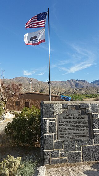
Vallecito, in San Diego County, California, is an oasis of cienegas and salt grass along Vallecito Creek and a former Kumeyaay settlement on the edge of the Colorado Desert in the Vallecito Valley. Its Spanish name is translated as "little valley". Vallecito was located at the apex of the gap in the Carrizo Badlands created by Carrizo Creek and its wash in its lower reach, to which Vallecito Creek is a tributary. The springs of Vallecito, like many in the vicinity, are a product of the faults that run along the base of the Peninsular Ranges to the west.
Steamboats on the Colorado River operated from the river mouth at the Colorado River Delta on the Gulf of California in Mexico, up to the Virgin River on the Lower Colorado River Valley in the Southwestern United States from 1852 until 1909, when the construction of the Laguna Dam was completed. The shallow draft paddle steamers were found to be the most economical way to ship goods between the Pacific Ocean ports and settlements and mines along the lower river, putting in at landings in Sonora state, Baja California Territory, California state, Arizona Territory, New Mexico Territory, and Nevada state. They remained the primary means of transportation of freight until the advent of the more economical railroads began cutting away at their business from 1878 when the first line entered Arizona Territory.
Jaeger's Ferry was a major river ferry at the Yuma Crossing of the Colorado River in the 1850s until 1862, 1 mile below Fort Yuma.
Invincible was a 120-ton topsail schooner, used as a transport for the U. S. Army Department of the Pacific in California from 1849 to 1851.
Alfred Henry Wilcox (1823-1883), sea captain, later Colorado River pioneer and steamboat and steamship entrepreneur, partner in the George A. Johnson & Company and of the Colorado Steam Navigation Company, banker and director of the California & Mexican Steam Ship Line.
George A. Johnson & Company was a partnership between three men who pioneered navigation on the Colorado River. Benjamin M. Hartshorne, George Alonzo Johnson and Alfred H. Wilcox. The George A. Johnson & Company was formed in the fall of 1852, and was reorganized as the Colorado Steam Navigation Company in 1869.
Cooke's Wagon Road or Cooke's Road was the first wagon road between the Rio Grande and the Colorado River to San Diego, through the Mexican provinces of Nuevo México, Chihuahua, Sonora and Alta California, established by Philip St. George Cooke and the Mormon Battalion, from October 19, 1846 to January 29, 1847 during the Mexican–American War. It became the first of the wagon routes between New Mexico and California that with subsequent modifications before and during the California Gold Rush eventually became known as the Southern Trail or Southern Emigrant Trail.
Sierra Nevada was a schooner, used as a transport for the U. S. Army Department of the Pacific in California to carry supplies for Fort Yuma to the mouth of the Colorado River in 1853–1854.
Fort Romualdo Pacheco also called Fuerte de Laguna Chapala was a Mexican fort built in 1825 and was abandoned a year later in 1826. The fort was 100 feet square with thick stone and adobe walls. The fort was built by Lieutenant Alfrez Jose Antonio Romualdo Pacheco Sr. in response to the attacked on travelers on the route made by Juan Bautista de Anza's expedition in 1774 from Sonora to Alta California. The fort was built after Fernando Rivera y Moncada, many of his soldiers, Francisco Garcés and his local missionaries, were killed at Mission San Pedro y San Pablo de Bicuñer in that is called the Yuma Revolt or Yuma Massacre on July 18, 1781. The attack was by the Apache Quechan Indians. The Yuma Massacre closed the overland transportation between northern Mexico and Alta California for 50 years. This halted the immigration of Mexicans to Alta California. Lieutenant Pacheco with soldiers and cavalry from the Presidio de San Diego built the fort in later 1825 and early 1826. The fort was built just north of the New River and south of the Bull Head Slough in what is now Imperial, California. The Fort was only used for a few months in 1826. Pacheco returned to San Diego and put Ignacio Delgado in charge of the Fort. On April 26, 1826, the San Sebastian Kumeyaay Indians attacked the fort. Pacheco had heard about rumors of the attack and arrived during the attack with reinforcements from San Diego. Pacheco and his 25 lancers fought off the attack. In the battle, three soldiers were killed and three injured. In the battle, 28 Indians were killed. But, now the fort was surrounded by many Kumeyaay and Quechan warriors. Vastly outnumbered the Fort was abandoned and all returned to San Diego. Archeologists did digs at the site in 1958 before Imperial Valley College Museum removed the remains.
Camp Salvation was a refugee camp set up on September 23, 1849, to help those traveling to the California Gold Rush. Emigrants were crossing the harsh Sonoran Desert to get to California through the Southern Emigrant Trail. The camp was located in the current town of Calexico, California. Lieutenant Cave Johnson Couts, an Escort Commander with the International Boundary Commission set up the camp. From September 23 till December 1, 1849, the camp helped travelers on the trail. In June 1849 the United States Boundary Commission arrived in San Diego to survey the international border between United States and Mexico.