Related Research Articles
The Cocopah are Native Americans who live in Baja California, Mexico, and Arizona, United States.
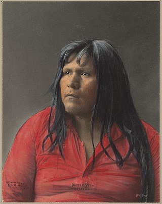
The Quechan, or Yuma, are a Native American tribe who live on the Fort Yuma Indian Reservation on the lower Colorado River in Arizona and California just north of the Mexican border. Despite their name, they are not related to the Quechua people of the Andes. Members are enrolled into the Quechan Tribe of the Fort Yuma Indian Reservation. The federally recognized Quechan tribe's main office is located in Winterhaven, California. Its operations and the majority of its reservation land are located in California, United States.
John Joel Glanton was an early settler of Arkansas Territory. He was also a Texas Ranger and a soldier in the Mexican–American War and the leader of a notorious gang of scalp-hunters in Northern Mexico and the Southwestern United States during the mid-19th century. Contemporary sources also describe him as a murderous outlaw and prominent participant in the Texas Revolution. He appears as a violent figure in the works of the prominent Western writers Larry McMurtry and Cormac McCarthy.

Blood Meridian; or, The Evening Redness in the West is a 1985 epic historical novel by American author Cormac McCarthy, classified under the Western, or sometimes the anti-Western, genre. McCarthy's fifth book, it was published by Random House.

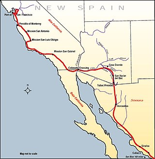
The Juan Bautista de Anza National Historic Trail is a 1,210-mile (1,950 km) trail extending from Nogales on the U.S.-Mexico border in Arizona, through the California desert and coastal areas in Southern California and the Central Coast region to San Francisco. The trail commemorates the 1775–1776 land route that Spanish commander Juan Bautista de Anza took from the Sonora y Sinaloa Province of New Spain in Colonial Mexico through to Las Californias Province. The goal of the trip was to establish a mission and presidio on the San Francisco Bay. The trail was an attempt to ease the course of Spanish colonization of California by establishing a major land route north for many to follow. It was used for about five years before being closed by the Quechan (Yuma) Indians in 1781 and kept closed for the next 40 years. It is a National Historic Trail administered by the National Park Service and was also designated a National Millennium Trail.
The Yuma Expedition was a U.S. Army military operation from 8 February 1852 to October 1852 in the Yuma War.

Fort Yuma was a fort in California located in Imperial County, across the Colorado River from Yuma, Arizona. It was Established in 1848. It served as a stop on the Butterfield Overland Mail route from 1858 until 1861. The fort was retired from active military service on May 16, 1883, and transferred to the Department of the Interior. The Fort Yuma Indian School and the Saint Thomas Yuma Indian Mission now occupy the site. It is one of the "associated sites" listed as Yuma Crossing and Associated Sites on the National Register of Historic Places in the Yuma Crossing National Heritage Area. In addition, it is registered as California Historical Landmark #806.
The history of California can be divided into the Native American period, the European exploration period (1542–1769), the Spanish colonial period (1769–1821), the Mexican period (1821–1848), and United States statehood. California was one of the most culturally and linguistically diverse areas in pre-Columbian North America. After contact with Spanish explorers, many of the Native Americans died from foreign diseases. Finally, in the 19th century there was a genocide by United States government and private citizens, which is known as the California genocide.

The Yavapai are a Native American tribe in Arizona. Their Yavapai language belongs to the Upland Yuman branch of the proposed Hokan language family.

Yuma Crossing is a site in Arizona and California that is significant for its association with transportation and communication across the Colorado River. It connected New Spain and Las Californias in the Spanish Colonial period in and also during the Western expansion of the United States. Features of the Arizona side include the Yuma Quartermaster Depot and Yuma Territorial Prison. Features on the California Side include Fort Yuma, which protected the area from 1850 to 1885.

The Yuma War was the name given to a series of United States military operations conducted in southern California and what is today southwestern Arizona from 1850 to 1853. The Quechan were the primary opponent of the United States Army, though engagements were fought between the Americans and other native groups in the region.
George Alonzo Johnson (1824–1903) was an American entrepreneur and politician.
Pima Villages, sometimes mistakenly called the Pimos Villages in the 19th century, were the Akimel O’odham (Pima) and Pee-Posh (Maricopa) villages in what is now the Gila River Indian Community in Pinal County, Arizona. First, recorded by Spanish explorers in the late 17th century as living on the south side of the Gila River, they were included in the Viceroyalty of New Spain, then in Provincias of Sonora, Ostimuri y Sinaloa or New Navarre to 1823. Then from 1824 to 1830, they were part of the Estado de Occidente of Mexico and from September 1830 they were part of the state of Sonora. These were the Pima villages encountered by American fur trappers, traders, soldiers and travelers along the middle Gila River from 1830s into the later 19th century. The Mexican Cession following the Mexican American War left them part of Mexico. The 1853 Gadsden Purchase made their lands part of the United States, Territory of New Mexico. During the American Civil War, they became part of the Territory of Arizona.
The California Indian Wars were a series of wars, battles, and massacres between the United States Army, and the Indigenous peoples of California. The wars lasted from 1850, immediately after Alta California, acquired during the Mexican–American War, became the state of California, to 1880 when the last minor military operation on the Colorado River ended the Calloway Affair of 1880.
Steamboats on the Colorado River operated from the river mouth at the Colorado River Delta on the Gulf of California in Mexico, up to the Virgin River on the Lower Colorado River Valley in the Southwestern United States from 1852 until 1909, when the construction of the Laguna Dam was completed. The shallow draft paddle steamers were found to be the most economical way to ship goods between the Pacific Ocean ports and settlements and mines along the lower river, putting in at landings in Sonora state, Baja California Territory, California state, Arizona Territory, New Mexico Territory, and Nevada state. They remained the primary means of transportation of freight until the advent of the more economical railroads began cutting away at their business from 1878 when the first line entered Arizona Territory.
Jaeger's Ferry was a major river ferry at the Yuma Crossing of the Colorado River in the 1850s until 1862, 1 mile below Fort Yuma.
George A. Johnson & Company was a partnership between three men who pioneered navigation on the Colorado River. Benjamin M. Hartshorne, George Alonzo Johnson and Alfred H. Wilcox. The George A. Johnson & Company was formed in the fall of 1852, and was reorganized as the Colorado Steam Navigation Company in 1869.

The Pochea Indian village site was the home of the Pochea Indians in what is now Hemet, California in Riverside County, California. The Pochea Indian village site was designated a California Historic Landmark (No.104) on March 29, 1933. The site of the Pochea Indian village is currently at the Ramona Bowl at 27400 Ramona Bowl, Hemet, California. The Pochea Indians lived in a small groups. These groups made up the indigenous peoples of California group called Pahsitnah.
Fort Romualdo Pacheco also called Fuerte de Laguna Chapala was a Mexican fort built in 1825 and was abandoned a year later in 1826. The fort was 100 feet square with thick stone and adobe walls. The fort was built by Lieutenant Alfrez Jose Antonio Romualdo Pacheco Sr. in response to the attacked on travelers on the route made by Juan Bautista de Anza's expedition in 1774 from Sonora to Alta California. The fort was built after Fernando Rivera y Moncada, many of his soldiers, Francisco Garcés and his local missionaries, were killed at Mission San Pedro y San Pablo de Bicuñer in that is called the Yuma Revolt or Yuma Massacre on July 18, 1781. The attack was by the Apache Quechan Indians. The Yuma Massacre closed the overland transportation between northern Mexico and Alta California for 50 years. This halted the immigration of Mexicans to Alta California. Lieutenant Pacheco with soldiers and cavalry from the Presidio de San Diego built the fort in later 1825 and early 1826. The fort was built just north of the New River and south of the Bull Head Slough in what is now Imperial, California. The Fort was only used for a few months in 1826. Pacheco returned to San Diego and put Ignacio Delgado in charge of the Fort. On April 26, 1826, the San Sebastian Kumeyaay Indians attacked the fort. Pacheco had heard about rumors of the attack and arrived during the attack with reinforcements from San Diego. Pacheco and his 25 lancers fought off the attack. In the battle, three soldiers were killed and three injured. In the battle, 28 Indians were killed. But, now the fort was surrounded by many Kumeyaay and Quechan warriors. Vastly outnumbered the Fort was abandoned and all returned to San Diego. Archeologists did digs at the site in 1958 before Imperial Valley College Museum removed the remains.
The Halyikwamai were a Native American tribe who lived along the Colorado River in the Lower Colorado River Valley between the 16th and 19th centuries in what is modern day region around San Luis Río Colorado, Sonora and San Luis, Arizona. The tribe spoke an extinct variation of the Cocopah language. The tribe was incorporated into the Maricopa in the middle of the 19th century.
References
- 1 2 Secrest, William B. (2003). When the great spirit died: the destruction of the California Indians, 1850–1860. Sanger, California: Quill Driver Books. p. 52. ISBN 9781884995408.
- ↑ "John Joel Glanton", Texas Handbook of History Online, accessed 2 December 2009